
The Swiss rail network is noteworthy for its density, its coordination between services, its integration with other modes of transport, timeliness and a thriving domestic and trans-Alp freight system. It is made necessary by strong regulations on truck transport, and is enabled by properly coordinated intermodal logistics.

The Reichenbach Falls are a waterfall cascade of seven steps on the stream called Rychenbach in the Bernese Oberland region of Switzerland. They drop over a total height of about 250 metres (820 ft). At 110 metres (360 ft), the upper falls, known as the Grand Reichenbach Fall, is by far the tallest segment and one of the highest waterfalls in the Alps, and among the forty highest in Switzerland. The Reichenbach loses 290 metres (950 ft) of height from the top of the falls to the valley floor of the Haslital. Today, a hydroelectric power company harnesses the flow of the Reichenbach Falls during certain times of year, reducing its flow.
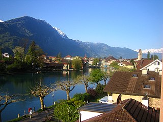
Interlaken is a Swiss town and municipality in the Interlaken-Oberhasli administrative district in the canton of Bern. It is an important and well-known tourist destination in the Bernese Oberland region of the Swiss Alps, and the main transport gateway to the mountains and lakes of that region.

Lake Brienz is a lake just north of the Alps, in the canton of Bern in Switzerland. It has a length of about 14 kilometres (8.7 mi), a width of 2.8 kilometres (1.7 mi) and a maximum depth of 260 metres (850 ft). Its area is 29.8 square kilometres (11.5 sq mi); the surface is 564 metres (1,850 ft) above the sea-level. It is fed, among others, by the upper reaches of the Aare at its eastern end, the Giessbach at its southern shore from steep, forested and rocky hills of the high Faulhorn and Schwarzhoren more than 2,000 metres (6,600 ft) above the lake, as well as by both headwaters of the Lütschine, the Schwarze Lütschine flowing from Grindelwald, and the Weisse Lütschine from the Lauterbrunnen Valley, at its southwestern corner. Not far north from Lütschine's inflow, the lake drains into a further stretch of the Aare at its western end. The culminating point of the lake's drainage basin is the Finsteraarhorn at 4,274 metres above sea level.

The Harderbahn (HB) is one of two funiculars that operate from the town of Interlaken. The Harderbahn leads to the western end of the Harder in the north of Interlaken across the river Aare, in Switzerland.
Kulm is a German language toponym derived from the Latin culmen, meaning hill, and may refer to:

The Jungfraujoch is a saddle connecting two major 4000ers of the Bernese Alps: the Jungfrau and the Mönch. It lies at an elevation of 3,463 metres (11,362 ft) above sea level and is directly overlooked by the rocky prominence of the Sphinx. The Jungfraujoch is a glacier saddle, on the upper snows of the Aletsch Glacier, and part of the Jungfrau-Aletsch area, situated on the boundary between the cantons of Bern and Valais, halfway between Interlaken and Fiesch.

The Grimsel Pass is a mountain pass in Switzerland, crossing the Bernese Alps at an elevation of 2,164 metres (7,100 ft). The pass connects the Haslital, the upper valley of the river Aare, with the upper valley of the Rhône. In so doing, and as the Aare is a tributary of the Rhine, the pass crosses the continental divide between the North Sea and the Mediterranean Sea.

The Bernese Oberland, sometimes also known as the Bernese Highlands, is the highest and southernmost part of the canton of Bern. It is one of the canton's five administrative regions. It constitutes the Alpine region of the canton and the northern side of the Bernese Alps, including many of its highest peaks, among which the Finsteraarhorn, the highest in both range and canton.

The Uetliberg is a mountain in the Swiss plateau, part of the Albis chain, rising to 870 m (2,850 ft). The mountain offers a panoramic view of the entire city of Zürich and the Lake of Zurich, and lies on the boundary between the city of Zürich and the municipalities of Stallikon and Uitikon. The summit, known as Uto Kulm, is in Stallikon.
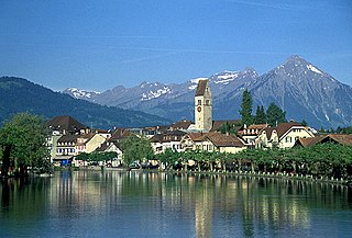
Unterseen is a historic town and a municipality in the Interlaken-Oberhasli administrative district in the canton of Bern in Switzerland.

Wilderswil railway station is a railway station in the village and municipality of Wilderswil in the Swiss canton of Bern. The station is on the Berner Oberland Bahn, whose trains operate services to Interlaken Ost, Grindelwald and Lauterbrunnen. It is also the valley terminus of the Schynige Platte Railway, whose trains operate to the Schynige Platte and are stabled at a depot bordering the station.
The Swiss 1. Liga is the fourth-highest ice hockey league in Switzerland, behind the National League, the Swiss League and the MySports League. The teams compete in three divisions – Eastern Switzerland, Central Switzerland and Western Switzerland.

The Schynige Platte is a small mountain ridge and a viewpoint in the Bernese Highlands and belongs to the Schwarzhorn group. The mountain range consists of three peaks: Gumihorn, Tuba, and the closest summit next to the viewpoint, Geiss. The viewpoint lies at an altitude of about 2,000 metres (7,000 ft), at the western end of a prominent ridge of the Schwarzhorn group, which separates the valley of the Schwarze Lütschine from Lake Brienz.

Lauterbrunnen is a railway station in the village and municipality of Lauterbrunnen in the Swiss canton of Bern. The station is on the Berner Oberland Bahn (BOB), whose trains operate services to Interlaken Ost. It is also the valley terminus of the Wengernalpbahn (WAB), whose trains operate to Kleine Scheidegg via Wengen, and of the Bergbahn Lauterbrunnen-Mürren (BLM), whose hybrid cable car and rail link runs to Mürren. Before 2006, this was a funicular.
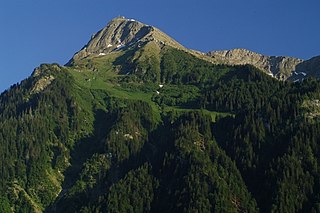
The Niesen is a mountain peak of the Bernese Alps in the Canton of Bern, Switzerland. The summit of the mountain is 2,362 metres (7,749 ft) in elevation.

Eigerwand is a currently disused underground railway station on the Jungfrau railway, which runs to the Jungfraujoch from Kleine Scheidegg. The station is situated just behind the north wall of the Eiger, and its principal purpose was to allow passengers to observe the view through a series of windows carved into the rock face. Trains to Jungfraujoch used to stop at the station for five minutes.

Jungfraujoch is an underground railway station situated near the Jungfraujoch, in the canton of Valais, a few metres from the border with the canton of Bern. At 3,454 metres (11,332 ft) above sea level, it is the terminus of the Jungfrau Railway and the highest railway station in Switzerland and Europe. The Jungfrau Railway runs from Kleine Scheidegg in the Bernese Oberland, through the Jungfrau Tunnel and crosses the border between the two cantons shortly before the terminus.

The Niesenbahn is a funicular railway above Lake Thun in the canton of Bern, Switzerland. It links a lower terminus, in the village of Mülenen at 693 m and adjacent to Mülenen station on the Lötschberg railway line, with an upper terminus at 2336 m near the summit of Niesen, a viewpoint above the lake and Bernese Oberland.The funicular is divided into two portions with a total length of 3.5 kilometers, an elevation difference of 1643 meters, and a maximum slope of 68%.


