
India is situated north of the equator between 8°4' north to 37°6' north latitude and 68°7' east to 97°25' east longitude. It is the seventh-largest country in the world, with a total area of 3,287,263 square kilometres (1,269,219 sq mi). India measures 3,214 km (1,997 mi) from north to south and 2,933 km (1,822 mi) from east to west. It has a land frontier of 15,200 km (9,445 mi) and a coastline of 7,516.6 km (4,671 mi).

The Godavari is India's second longest river after the Ganga River and drains the third largest basin in India, covering about 10% of India's total geographical area. Its source is in Trimbakeshwar, Nashik, Maharashtra. It flows east for 1,465 kilometres (910 mi), draining the states of Maharashtra (48.6%), Telangana (18.8%), Andhra Pradesh (4.5%), Chhattisgarh (10.9%) and Odisha (5.7%). The river ultimately empties into the Bay of Bengal through an extensive network of distributaries. Measuring up to 312,812 km2 (120,777 sq mi), it forms one of the largest river basins in the Indian subcontinent, with only the Ganga and Indus rivers having a larger drainage basin. In terms of length, catchment area and discharge, the Godavari is the largest in peninsular India, and had been dubbed as the Dakshina Ganga.

The large Deccan Plateau in southern India is located between the Western Ghats and the Eastern Ghats, and is loosely defined as the peninsular region between these ranges that is south of the Narmada River. To the north, it is bounded by the Satpura and Vindhya Ranges.

The Nilgiris district is one of the 38 districts in the southern Indian state of Tamil Nadu. Nilgiri is the name given to a range of mountains spread across the borders among the states of Tamil Nadu, Karnataka and Kerala. The Nilgiri Hills are part of a larger mountain chain known as the Western Ghats. Their highest point is the mountain of Doddabetta, height 2,637 m. The district is contained mainly within the Nilgiri Mountains range. The administrative headquarters is located at Ooty. The district is bounded by Coimbatore to the south, Erode to the east, and Chamarajnagar district of Karnataka and Wayanad district of Kerala to the north. As it is located at the junction of three states, namely, Tamil Nadu, Kerala, and Karnataka, significant Malayali and Kannadiga populations reside in the district. Nilgiris district is known for natural mines of Gold, which is also seen in the other parts of Nilgiri Biosphere Reserve extended in the neighbouring states of Karnataka and Kerala too.

Nanded is a city in Maharashtra state, India. It is the tenth largest city in the state and the seventy-ninth most populous city in India. It is the second largest city in Marathwada region. It is the district headquarters of Nanded district.

The Garo Hills are part of the Garo-Khasi range in Meghalaya state of India. They are inhabited by the Garo people. It is one of the wettest places in the world. The range is part of the Meghalaya subtropical forests ecoregion.
Aurangabad is a city in Aurangabad District, Bihar, India. It is the district's centre of governance and has a population of 102,244 as of 2011. The people of this region speak Magahi and Hindi.

The Pir Panjal Range is a range of mountains in the Lower Himalayan region located in the Western Himalayas of northern Indian subcontinent. It runs southeast to northwest between the Beas and Neelam/Kishanganga rivers, in the Indian state of Himachal Pradesh and Indian-administered union territory of Jammu and Kashmir, with its northwestern end extending into territory administered by Pakistan. The Himalayas show a gradual elevation towards the Dhauladhar and Pir Panjal ranges. Pir Panjal is the largest and westernmost range of the Lesser Himalayas. Near the bank of the Sutlej River, it dissociates itself from the main Himalayan range and forms a divide between the Beas and Ravi rivers on one side and the Chenab on the other. Further west, the Pir Panjal range forms the southwestern boundary of the Kashmir Valley, separating it from the hills of Jammu region, forming a divide between the Jhelum and Chenab rivers.

Nashik district, formerly known as Nasik district, is a district in Maharashtra, India. The city of Nashik is the administrative headquarters of the district. Nashik is well known for the production of wine. Nashik is also known as Mini Maharashtra, because the climate and soil conditions of Surgana, Peth, Igatpuri resembles with Konkan. Niphad, Sinnar, Dindori, Baglan blocks are like Western Maharashtra and Yeola, Nandgaon, Chandwad blocks are like Vidarbha Region. Nashik is the biggest city in the district while Malegaon is the second biggest city. Manmad, Igatpuri, and Sinnar are some of the big cities situated in the Nashik District. Manmad is one of the biggest railway junctions in India while the city of Malegaon is famous for its powerloom.
The Great Himalayas or Greater Himalayas or Himadri is the highest mountain range of the Himalayan Range. The world's highest peak, Mount Everest, as well as other "near−highest" peaks, such as Kangchenjunga, Lhotse, and Nanga Parbat, are part of the Greater Himalayas range. The total west to east extension of the Great Himalayas is 2400 km and their average elevation is 6000 m (20000 ft.).

The word Maharashtra, the land of the mainly Marathi-speaking people, appears to be derived from Maharashtri, an old form of Prakrit. Some believe that the word indicates that it was the land of the Mahars and the Rattas, while others consider it to be a corruption of the term 'Maha Kantara', a synonym for 'Dandakaranya'. Maharashtra is the third largest state in India after Rajasthan and Madhya Pradesh. It covers an area of 307,713 km2 and is bordered by the states of Madhya Pradesh to the north, Chhattisgarh to the east, Telangana to the southeast, Karnataka to the south and Goa to the southwest. The state of Gujarat lies to the northwest, with the Union territory of Dadra and Nagar Haveli sandwiched between the borders. Maharashtra has coastline of 720 km.The Arabian Sea makes up Maharashtra's west coast. Maharashtra consists of two major relief divisions. The plateau is a part of the Deccan tableland and the Konkan coastal strip abutting on the Arabian Sea.

Kunchikal Falls is a waterfall in India located in the Nidagodu village near Masthikatte in the Shimoga district of Karnataka state. Kunchikal Falls cascades down rocky boulders and the total height of the falls is 455 meters, according to the World Waterfall Database. Kunchikal Falls is formed by the Varahi river.

The state of Maharashtra in India has several major river systems including those of the Narmada, Tapti, Godavari and Krishna rivers. The ecology of these rivers and associated wetlands is covered in this article.

The Geography of South India comprises the diverse topological and climatic patterns of South India. South India is a peninsula in the shape of a vast inverted triangle, bounded on the west by the Arabian Sea, on the east by the Bay of Bengal and on the north by the Vindhya and Satpura ranges.

Odisha is one of the 28 states in the Republic of India. Odisha is located in the eastern part of the Indian peninsula and the Bay of Bengal lies to its East while Chhattisgarh shares its border in the west and north-west. The state also shares geographic boundaries with West Bengal in the north-east, Jharkhand in the north and Andhra Pradesh in the south. The state is spread over an area of 1,55,707 km2 and extends for 700 km from north to south and 500 kilometres from east to west. Its coastline is 450 km long. The state is divided into 30 districts which are further subdivided into 317 blocks called tahasil.

Uttarakhand has a total geographic area of 53,483 km2, of which 86% is mountainous and 65% is covered by forest. Most of the northern parts of the state are part of Greater Himalaya ranges, covered by the high Himalayan peaks and glaciers, while the lower foothills were densely forested till denuded by the British log merchants and later, after independence, by forest contractors. Recent efforts in reforestation, however, have been successful in restoring the situation to some extent. The unique Himalayan ecosystem plays host to many animals, plants and rare herbs. Two of India's great rivers, the Ganges and the Yamuna take birth in the glaciers of Uttarakhand, and are fed by myriad lakes, glacial melts and streams.

The Malabar Coast is the southwestern region of the Indian subcontinent. It generally refers to the western coastline of India stretching from Konkan to Kanyakumari. Geographically, it comprises one of the wettest regions of the subcontinent, which includes the Kanara region of Karnataka and all of Kerala.

The Garhjat Hills is a mountain range formed by a series low-lying hills, plateaux, ridges and meadows that stretch into Odisha from the Utkal Plains in the Chotanagpur region of Jharkhand and the Chhattisgarh Plains. The range, also known as the Odisha Highlands, runs in a north east to south west direction for about 382 km along the Odisha coast, covering 76,800 km2 (29,700 sq mi).
Palkonda Hills are a range of hills that form a part of the Eastern Ghats in the southern Indian state of Andhra Pradesh. Meaning "milk hills", they run along a northwest to southeast direction, culminating at the pilgrimage centre of Tirupati.
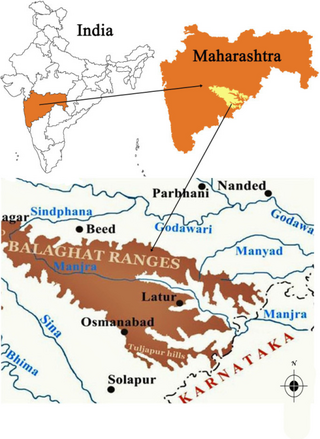
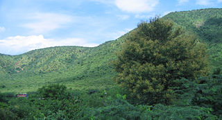
Balaghat range is a mountain range of low elevation in the Maharashtra state of India. Balaghat Range runs south-eastwards from Western Ghats at the Harishchandra Range to the border of Maharashtra and Karnataka states. It extends about 320 kilometers. The range traverses the districts of Ahmednagar, Beed, Latur, Osmanabad and Solapur in Maharashtra.
