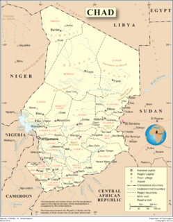
Chad is one of the 48 land-locked countries in the world and is located in North Central Africa, measuring 1,284,000 square kilometers (495,755 sq mi), nearly twice the size of France and slightly more than three times the size of California. Most of its ethnically and linguistically diverse population lives in the south, with densities ranging from 54 persons per square kilometer in the Logone River basin to 0.1 persons in the northern B.E.T. (Borkou-Ennedi-Tibesti) desert region, which itself is larger than France. The capital city of N'Djaména, situated at the confluence of the Chari and Logone Rivers, is cosmopolitan in nature, with a current population in excess of 700,000 people.

The Philippines is an archipelago that comprises 7,641 islands with a total land area of 300,000 square kilometers (115,831 sq mi). It is the world's 5th largest island country. The eleven largest islands contain 95% of the total land area. The largest of these islands is Luzon at about 105,000 square kilometers (40,541 sq mi). The next largest island is Mindanao at about 95,000 square kilometers (36,680 sq mi). The archipelago is around 800 kilometers (500 mi) from the Asian mainland and is located between Taiwan and Borneo.

Rønde is a town on the southern part of the peninsula, Djursland in Denmark, Northern Europe, 23 kilometers north-east of the north end of Denmark's second largest city, Aarhus. It is in part a commuter town to Aarhus, with a motorway entering Aarhus from the north. Rønde is located between Aarhus, and Aarhus Airport with a 12 kilometer drive from Rønde to the airport.

The Dziwna is a channel of the Oder River in northwestern Poland, one of three straits connecting the Oder Lagoon with the Bay of Pomerania of the Baltic Sea. It separates the island of Wolin from the rest of the Polish mainland. The other two channels are the Świna and the Peene.
Tosontsengel is a sum of Khövsgöl aimag. The area is 2,050 km², of which 1,800 km² are pasture and 11 km² are farmland. In 2000, Tosontsengel had a population of 4,161 people, including some Khotgoid. The sum center, officially named Tsengel, is located 64 km east-southeast of Mörön and 607 km from Ulaanbaatar.
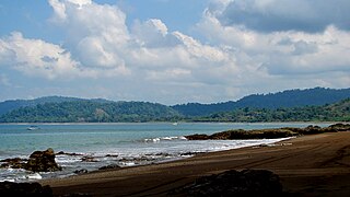
Bahía Drake is a small bay on the north side of the Osa Peninsula on the coast of southwestern Costa Rica.
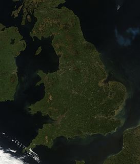
England comprises most of the central and southern two-thirds of the island of Great Britain, in addition to a number of small islands of which the largest is the Isle of Wight. England is bordered to the north by Scotland and to the west by Wales. It is closer to continental Europe than any other part of mainland Britain, divided from France only by a 33 km (21 mi) sea gap, the English Channel. The 50 km (31 mi) Channel Tunnel, near Folkestone, directly links England to mainland Europe. The English/French border is halfway along the tunnel.

Lake Paiku is a lake at 4,591 meters (15,062 ft) elevation on the Tibetan Plateau at 28°55′N85°35′E, 18 kilometers (11 mi) south of the Yarlung Tsangpo (Brahmaputra) River. The lake is 27 kilometers (17 mi) long and 6 kilometers (3.7 mi) wide at its narrowest. It is surrounded by mountains reaching 5,700 to 6,000 meters. Streams fed by glaciers cascade to the valley floor, but most sink into alluvial deposits before reaching the lake.
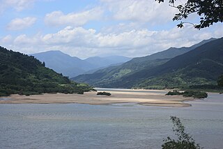
The Seomjin River is a river in South Korea. It drains southeastern Jeollabuk-do as well as eastern Jeollanam-do and western Gyeongsangnam-do provinces, and flows into the Korea Strait. The Seomjin rises from Palgongsan and flows for 212.3 kilometers before reaching its final destination in Gwangyang, where it enters Gwangyang Bay.

Veenhuizen is a village with around 800 inhabitants in the province of Drenthe in the Netherlands. In the early 19th century, a reform housing colony for the poor and homeless was established in Veenhuizen. In the late 19th century, the complex was turned into a penal colony. The village became freely accessible in 1984 and has been part of the municipality of Noordenveld since 1998. The National Prison Museum is located here.

Ashūradeh, or Ashur Ada, is the only island of the Iranian coast of the Caspian Sea. Ashuradeh's surface is 800 hectares . It is located on the eastern end of the Miankaleh peninsula in the county of Behshahr of Māzandarān Province of Iran, 3 kilometers (1.9 mi) from Bandar Torkaman and 23 kilometers (14 mi) from Gorgan.
Ikh-Uul is a sum of Khövsgöl aimag. The area is about 2,020 km², of which 1,350 km² are pasture and about 11 km² are farmland. In 2000, the sum had 3959 inhabitants, mainly Khalkha and Khotgoid. The center, officially named Selenge, is situated close to the Selenge river, 112 km east of Mörön and 589 kilometers from Ulaanbaatar.
Agricultural land is typically land devoted to agriculture, the systematic and controlled use of other forms of life—particularly the rearing of livestock and production of crops—to produce food for humans. It is thus generally synonymous with both farmland or cropland, as well as pasture or rangeland.

Frednowy is a village in the administrative district of Gmina Iława, within Iława County, Warmian-Masurian Voivodeship, in northern Poland. It lies approximately 12 kilometres (7 mi) north-east of Iława and 55 km (34 mi) west of the regional capital Olsztyn.

Harlesiel is a resort town on the East Frisian coast of Germany, at the mouth of the Harle River. It lies in the Wittmund district, about 1 kilometre (0.62 mi) north of Carolinensiel. It is a small town, with a population of 809 in 2009, swelled by some 4800 tourists in season.
German submarine U-828 was a Type VIIC/41 U-boat of Nazi Germany's Kriegsmarine during the Second World War. She saw no combat and was scuttled at the end of the war.
German submarine U-763 was a Type VIIC U-boat built for Nazi Germany's Kriegsmarine for service during World War II. She was laid down on 21 January 1941 by Kriegsmarinewerft Wilhelmshaven as yard number 146, launched on 16 January 1943 and commissioned on 13 March 1943 under Kapitänleutnant Ernst Cordes. On 1 November 1944, Oberleutnant zur See Karl-Heinz Schröter took over command as part of her transfer to 24th Flotilla..
Division No. 1, Subdivision H is an unorganized subdivision on the Avalon Peninsula in Newfoundland and Labrador, Canada. It is in Division 1 and contains the unincorporated communities of Clowns Cove, Flatrock, Freshwater, Halfway House, Perry's Cove and Spout Cove.

