Jade Bight

Last updated
Map showing Jade Bay (Jadebusen) at lower center Jade-weser-muendung map de.png
Map showing Jade Bay (Jadebusen) at lower center
Development of the Jade Bight and the interim Weser delta:
* blue areas = advancement of waterbodies
* green areas = growth of land
* grayish pale blue areas = sometimes flooded
* grayish lilac areas = newly gained land lost again
* grayish pink areas = regained land lost again
* brown to red lines = dikes
* bold intensive light blue line = today's coastline
* light blue lines = today's limit of mudflats
* bold pale blue lines = limit of mudflats c. 1810
* dirty lilac lines = limit of mudflats c. 1645
* light pink to light lilac, ocre and light green lines = geological soil borders.
Greenish coloured areas (except the few bluish green ones) represent new won land. Regaining of losses mostly is marked only by the dikes.
- This map for reading: * 33 % (216 dpi), * 50 % (144 dpi) JadeWeser.png
Development of the Jade Bight and the interim Weser delta:
• blue areas = advancement of waterbodies
• green areas = growth of land
• grayish pale blue areas = sometimes flooded
• grayish lilac areas = newly gained land lost again
• grayish pink areas = regained land lost again
• brown to red lines = dikes
• bold intensive light blue line = today's coastline
• light blue lines = today's limit of mudflats
• bold pale blue lines = limit of mudflats c. 1810
• dirty lilac lines = limit of mudflats c. 1645
• light pink to light lilac, ocre and light green lines = geological soil borders.
Greenish coloured areas (except the few bluish green ones) represent new won land. Regaining of losses mostly is marked only by the dikes.
→ This map for reading: • 33 % (216 dpi), • 50 % (144 dpi)

The Jade Bight [1] [2] (or Jade Bay; [3] German : Jadebusen) is a bight or bay on the North Sea coast of Germany. It was formerly known simply as Jade or Jahde. Because of the very low input of freshwater, it is classified as a bay rather than an estuary. [4]

Contents

Aerial view of Jade Bight Meeresbucht Jadebusen (Nordsee).jpg
Aerial view of Jade Bight

Intrusion of the sea

About 180 km² (70 mi²) in area, the Jade was largely created by storm floods during the 13th and 16th centuries. [5] Since the early 14th century, it has joined eastward to the estuary of the river Weser. For some time, there were three permanent connecting branches and one flood bed between the river and the bight, forming an estuarine delta. The first of these junctions was closed in 1450 by dikes and the last one in 1515. However, about a century passed before most of the area flooded by these connections was regained for pasture and arable land.

In the west, the Jade extended far into the Frisian peninsula. From the early 16th century, a number of dikes were built against the storm floods and to gain arable land. The main dike, Ellenser Damm, was built between 1596 and 1615 by the County of Oldenburg before the agreement with the objecting County of East Frisia was finished successfully.

Decay of the Frisian community

The extension of Jade Bight and its branches fragmented the free Frisian territory of Rüstringen in Bant in the northwest, most of which has disappeared in the waves, Bovenjadingen ('above the Jade') with the low moraine hills of Friesische Wehde in the southwest, Butjadingen ('outside the Jade') in the northeast, which was an island for almost two centuries, and Stadland ('bank-land'), which became a narrow island along the left bank of the Weser in 1384. The devastation by floods and the losses of land weakened the Frisian community. In the years about 1400, the Free City of Bremen tried to rule Stadland and Butjadingen. At the beginning of 16th century, all countries around Jade Bight were conquered by the Counts of Oldenburg.

Organized construction of dikes

Together with the conquest of the island of Stadland, the Lockfleth, the largest branch of the Weser delta, was interrupted by a dike at Ovelgönne in 1515. In the next years the water course was cut off at more sites. The most important projects prior to 1650 were the Ellenser Damm across the Schwarzes Brack in the west of the bay in 1596 to 1615 and the New Hoben-Dike in the east in 1643. South of this dike, the coast became a mossy bog. The bog was affected by high floods, and dikes built on the bog proved to be very fragile.

Harbour

Tidal flows make the neck of Jade Bight the deepest natural channel near Germany's North Sea coast. In 1853, the Kingdom of Prussia bought a part of the western shore of the bay from Oldenburg, in order to use the harbour as a Prussian naval base, later called Wilhelmshaven. During World War I, the German High Seas Fleet (Hochseeflotte), the main battle fleet of the Imperial German Navy ( Kaiserliche Marine ), was based at Wilhelmshaven in the Jade Bight. After World War II, Wilhelmshaven became the main German port for the import of petroleum.

Nature

The foreshore areas of Jade Bight form a part of the German Wadden Sea National Parks.

Jadebusen and river Weser estuary SatJadebusen-Wesermuendung.jpg
Jadebusen and river Weser estuary

Related Research Articles

<span class="mw-page-title-main">Frisia</span> Cross-border cultural region in Northern Europe

Frisia is a cross-border cultural region in Northwestern Europe. Stretching along the Wadden Sea, it encompasses the north of the Netherlands and parts of northwestern Germany. The region is traditionally inhabited by the Frisians, a West Germanic ethnic group.

Friesland is a district (Landkreis) in Lower Saxony, Germany. It is bounded by the districts of Wesermarsch, Ammerland, Leer and Wittmund, and by the North Sea. The city of Wilhelmshaven is enclosed by—but not part of—the district.

<span class="mw-page-title-main">Wilhelmshaven</span> Town in Lower Saxony, Germany

Wilhelmshaven is a coastal town in Lower Saxony, Germany. It is situated on the western side of the Jade Bight, a bay of the North Sea, and has a population of 76,089. Wilhelmshaven is the centre of the "Jade Bay" business region and is Germany's main military port.

Wesermarsch is a Kreis (district) in the northwestern part of Lower Saxony, Germany. Neighboring are the districts of Cuxhaven and Osterholz, the city of Bremen in the state Free Hanseatic City of Bremen, the urban district of Delmenhorst, the district of Oldenburg and the urban district of Oldenburg, and the districts of Ammerland and Friesland.

<span class="mw-page-title-main">Frisian Islands</span> Archipelago in the Wadden Sea

The Frisian Islands, also known as the Wadden Islands or the Wadden Sea Islands, form an archipelago at the eastern edge of the North Sea in northwestern Europe, stretching from the northwest of the Netherlands through Germany to the west of Denmark. The islands shield the mudflat region of the Wadden Sea from the North Sea.

<span class="mw-page-title-main">Nordenham</span> Town in Lower Saxony, Germany

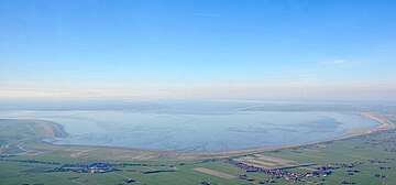
Nordenham is a town in the Wesermarsch district, in Lower Saxony, Germany. It is located at the mouth of the Weser river on the Butjadingen peninsula on the coast of the North Sea. The seaport city of Bremerhaven is located on the other side of the river. The Midgard-seaport in Nordenham is the largest private-owned harbor in Germany.

<span class="mw-page-title-main">Butjadingen</span> Municipality in Lower Saxony, Germany

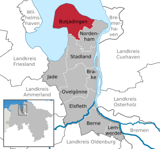
Butjadingen is a peninsula and municipality in the Wesermarsch district, in Lower Saxony, Germany.

<span class="mw-page-title-main">German Bight</span> Geographic feature along the coasts of Denmark, Germany, and the Netherlands

The German Bight is the southeastern bight of the North Sea bounded by the Netherlands and Germany to the south, and Denmark and Germany to the east. To the north and west it is limited by the Dogger Bank. The Bight contains the Frisian and Danish Islands. The Wadden Sea is approximately ten to twelve kilometres wide at the location of the German Bight. The Frisian islands and the nearby coastal areas are collectively known as Frisia. The southern portion of the bight is also known as the Heligoland Bight. Between 1949 and 1956 the BBC Sea Area Forecast used "Heligoland" as the designation for the area now referred to as German Bight.

<span class="mw-page-title-main">JadeWeserPort</span> Container terminal in Wilhelmshaven, Germany.

JadeWeserPort is Germany's largest harbour project. It is supported by the states of Lower Saxony and Bremen. This new container port is located at Wilhelmshaven at the Jade Bight, a bay on the North Sea coast. It has a natural water depth in excess of 18 m. Container ships with a length of 430 m and 16,5 m draught will be able to call the JadeWeserPort at any tide. Construction work was begun in March 2008. The port was opened on 21 September 2012. However, due to the Great Recession, the port wasn't given the warmest of welcomes, and very little TEU traffic flowed through the brand new harbour. But the container handling could be raised from 60,000 in 2014 to 426,700 twenty-foot equivalent unit in 2015. The yearly capacity of the port is 2,700,000 TEU.

<span class="mw-page-title-main">Heligoland Bight</span> Bay in the North Sea

The Heligoland Bight, also known as Helgoland Bight, is a bay which forms the southern part of the German Bight, itself a bay of the North Sea, located at the mouth of the Elbe river. The Heligoland Bight extends from the mouth of the Elbe to the islands of Heligoland and lies between the East Frisian island of Wangerooge and the North Frisian peninsula of Eiderstedt.

<span class="mw-page-title-main">Sande, Lower Saxony</span> Municipality in Lower Saxony, Germany

Sande is a municipality in the district of Friesland, Lower Saxony, Germany. It is situated near the Jade Bight, approximately 7 kilometres (4.3 mi) west of Wilhelmshaven, and 12 kilometres (7.5 mi) southeast of Jever.

<span class="mw-page-title-main">Stadland</span> Municipality in Lower Saxony, Germany

Stadland is a municipality in the district of Wesermarsch, in Lower Saxony, Germany. It is situated on the left bank of the Weser, approx. 32 km northeast of Oldenburg, and 42 km northwest of Bremen. On the west side Stadland bordered to the Jade Bight. Its seat is in the village Rodenkirchen, which is also part of this municipality as the villages Schwei, Seefeld and Kleinensiel. There are also many little Bauernschaften (hamlets) in Stadland.

<span class="mw-page-title-main">Jade Treaty</span> 1853 treaty between Prussia and Oldenburg

The Jade Treaty of 20 July 1853 between the Kingdom of Prussia and the Grand Duchy of Oldenburg provided for the handover of 340 hectares of Oldenburg territory at what is now Wilhelmshaven, Germany, on the western shore of the Jade Bight, a bay of the North Sea west of Bremerhaven. It was considered the best natural deep-water port in the German North Sea coast, and a good place for the naval base Prussia wished to build. The navy base built there became the nucleus of today's Wilhelmshaven.

<span class="mw-page-title-main">Weser Depression</span>

The Weser Depression or Weser Lowlands is the region north of Porta Westfalica in Germany, where the River Weser no longer flows through a valley, but a broad plain consisting of meadows and river terraces.

<span class="mw-page-title-main">Land Hadeln</span>

Land Hadeln is a historic landscape and former administrative district in Northern Germany with its seat in Otterndorf on the Lower Elbe, the lower reaches of the River Elbe, in the Elbe-Weser Triangle between the estuaries of the Elbe and Weser.

<span class="mw-page-title-main">East Frisia (peninsula)</span> All Frisian areas in Lower Saxony, Germany

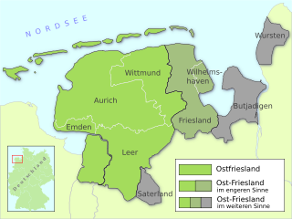
East Frisia is a collective term for all traditionally Frisian areas in Lower Saxony, Germany, which are primarily located on a peninsula between the Dollart and the Jade Bight. Along with West Frisia and North Frisia, it is one of the most commonly used subdivisions of Frisia.

<span class="mw-page-title-main">Minsener Oog</span> East Frisian island

Minsener Oog, also Minser Oog or Minsener Oldeoog, is an uninhabited East Frisian island that belongs to the parish of Wangerooge in the north German district of Friesland in the state of Lower Saxony. It has been artificially enlarged through the construction of groynes.

<span class="mw-page-title-main">John V, Count of Oldenburg</span>

John V, Count of Oldenburg and Delmenhorst was a member of the House of Oldenburg. He was the ruling Count of Oldenburg from 1500 to 1526. His parents were Gerhard VI, Count of Oldenburg and Adelheid of Tecklenburg.

<span class="mw-page-title-main">John VII, Count of Oldenburg</span>

Count John VII of Oldenburg and Delmenhorst was a member of the House of Oldenburg and was the ruling Count of County of Oldenburg from 1573 until his death. His parents were Count Anthony I of Oldenburg and Sophie of Saxe-Lauenburg.

Peasant republic is a term used to describe rural societies in the Middle Ages, especially in the Holy Roman Empire, in which royal, aristocratic and ecclesiastical power was unusually weak or non-existent, allowing the local farmers to enjoy a high degree of autonomy. In this context the term 'republic' does not necessarily imply the existence of the apparatus of a formal state, though this did exist in some such communities, but rather simply the absence of effective royal/princely power. Typically peasant republics were located in remote and inaccessible areas which were difficult for outside authorities to interfere in, and generally too poor to attract a lot of attention.

References

  1. Elkins, T H (1972). Germany (3rd ed.). London: Chatto & Windus, 1972, p. 281. ASIN   B0011Z9KJA.
  2. Holden, Joseph (ed.) (2008), An Introduction to Physical Geography and the Environment, 2nd ed., Pearson, Harlow, 2008, p. 483. ISBN   978-0-13-175304-4.
  3. Britannica Online Encyclopedia: Jade Bay
  4. Günther Lang, Bundesanstalt für Wasserbau (Federal Bureau for Water-Bound Constructions): Ein Beitrag zur Tidedynamik der Innenjade und des Jadebusens (A contribution on the tidal dynamics of Innenjade and Jadebusen) (in German)
  5. Chisholm, Hugh, ed. (1911). "Jade"  . Encyclopædia Britannica . Vol. 15 (11th ed.). Cambridge University Press. p. 122.

Sources

53°27′N8°12′E / 53.450°N 8.200°E / 53.450; 8.200