U.S. Route 113 (US 113) is a U.S. Highway that is a spur of US 13 in the U.S. states of Maryland and Delaware. The route runs 74.75 miles (120.30 km) from US 13 in Pocomoke City, Maryland, north to Delaware Route 1 (DE 1) in Milford, Delaware. In conjunction with DE 1, US 113 is one of two major north–south highways on the Delmarva Peninsula that connect Dover with Pocomoke City and the Eastern Shore of Virginia. The U.S. Highway is the primary north–south highway in Worcester County, Maryland, where it connects Pocomoke City with Snow Hill and Berlin. US 113 is one of three major north–south highways in Sussex County, Delaware, where it connects Selbyville, Millsboro, and Georgetown with Milford. While US 113 does not pass through Ocean City or the Delaware Beaches, the U.S. Highway intersects several highways that serve the Atlantic seaboard resorts, including US 50, Maryland Route 90 (MD 90), US 9, DE 404, DE 16, and DE 1. US 113 is a four-lane divided highway for its whole length.
Maryland Route 18 (MD 18) is a state highway in the U.S. state of Maryland. The state highway runs 20.37 miles (32.78 km) from the beginning of state maintenance at Love Point east to MD 213 in Centreville. MD 18 is the main east–west local highway on Kent Island and east to Centreville, serving the centers of Stevensville, Chester, Kent Narrows, Grasonville, and Queenstown that are bypassed by U.S. Route 50 (US 50)/US 301. What is signed as MD 18 is actually a set of four suffixed highways: MD 18A, MD 18B, MD 18S, and MD 18C. There are also several unsigned segments of MD 18 scattered along the length of the signed portions.
Maryland Route 213 (MD 213) is a 68.25-mile (109.84 km) state highway located on the Eastern Shore of Maryland in the United States. The route runs from MD 662 in Wye Mills, Queen Anne's County, north to the Pennsylvania border near Fair Hill in Cecil County, where the road continues into that state as Pennsylvania Route 841 (PA 841). The route, which is a two-lane undivided highway most of its length, passes through mainly rural areas as well as the towns of Centreville, Chestertown, Galena, Cecilton, Chesapeake City, and Elkton. MD 213 intersects many routes including U.S. Route 50 (US 50) near Wye Mills, US 301 near Centreville, and US 40 in Elkton. It crosses over the Chesapeake & Delaware Canal in Chesapeake City on the Chesapeake City Bridge. MD 213 is designated by the state as the Chesapeake Country Scenic Byway between the southern terminus and Chesapeake City with the portion north of MD 18 in Centreville a National Scenic Byway. In addition, the route is also considered part of the Atlantic to Appalachians Scenic Byway between Chesapeake City and MD 273 in Fair Hill.

Maryland Route 528 is a state highway in the U.S. state of Maryland. Known for most of its length as Coastal Highway, the state highway runs 9.04 miles (14.55 km) from the southern terminus of its companion route, unsigned Maryland Route 378, in downtown Ocean City north to the Delaware state line at the northern edge of the resort town, where the highway continues as Delaware Route 1. MD 528 and MD 378 are the primary north–south streets of Ocean City, where they provide access to countless hotels, condos, restaurants, shops, and other businesses catering to tourists. These highways experience heavy seasonal traffic and provide access to hurricane evacuation routes, which include U.S. Route 50, MD 90, and DE 54. Both Baltimore Avenue and Philadelphia Avenue date back to the founding of Ocean City in the late 19th century. MD 378 was assigned to Baltimore Avenue in 1927 and MD 528 was assigned to Philadelphia Avenue in 1933. MD 528 was extended north of 15th Street to the Delaware state line in 1939. Both highways were rebuilt and widened in the 1950s. MD 528 was expanded to a six-lane divided highway north of the one-way pair in the late 1980s.

Maryland Route 90 is a state highway in the U.S. state of Maryland. Known as the Ocean City Expressway, the state highway runs 11.83 miles (19.04 km) from U.S. Route 50 near Whaleyville east to MD 528 in Ocean City in Worcester County. MD 90 is a two-lane expressway that provides one of the main access routes to Ocean City, especially the northern part of the resort town, and thus sees heavy seasonal traffic. The highway was constructed from Ocean City starting in 1970. The state highway was opened west to MD 589 in 1972 and to US 113 in 1975. MD 90 was completed west to US 50 in 1976.
Maryland Route 16 (MD 16) is a state highway in the U.S. state of Maryland. The state highway runs 51.06 miles (82.17 km) from Taylors Island east to the Delaware state line in Hickman, where the highway continues as Delaware Route 16 (DE 16). MD 16 connects Cambridge with several communities in northern Dorchester County and southwestern Caroline County, including East New Market and Preston. The state highway runs concurrently with U.S. Route 50 (US 50) near Cambridge, MD 331 between East New Market and Preston, and both MD 404 and MD 313 near Andersontown. MD 16 was constructed between Church Creek and Preston as one of the original state roads in the early and mid-1910s. The highway was extended in both directions in the late 1910s: north to what was to be designated MD 313 near Denton and west to Taylors Island. MD 16 was extended through Andersontown to the Delaware state line in the early 1930s. MD 16's bypass of Cambridge was constructed in the mid-1960s.

U.S. Route 50 is a major east–west route of the U.S. Highway system, stretching just over 3,000 miles (4,800 km) from West Sacramento, California, east to Ocean City, Maryland, on the Atlantic Ocean. In the U.S. state of Maryland, US 50 exists in two sections. The longer of these serves as a major route connecting Washington, D.C., with Ocean City; the latter is the eastern terminus of the highway. The other section passes through the southern end of Garrett County for less than 10 miles (16 km) as part of the Northwestern Turnpike, entering West Virginia at both ends. One notable section of US 50 is the dual-span Chesapeake Bay Bridge across the Chesapeake Bay, which links the Baltimore–Washington metropolitan area with the Eastern Shore region, allowing motorists to reach Ocean City and the Delaware Beaches.
Maryland Route 313 (MD 313) is a state highway located on the Eastern Shore of Maryland in the United States. The 75.72-mile (121.86 km) route runs from U.S. Route 50 (US 50) in Mardela Springs, Wicomico County, north to MD 213 and MD 290 in Galena, Kent County. It is predominantly a rural two-lane undivided road that runs through agricultural areas a short distance west of the Delaware state line, with the exception of a four-lane divided bypass of Denton that is concurrent with MD 404. MD 313 serves many communities, including Sharptown, Eldorado, Federalsburg, Denton, Greensboro, Goldsboro, Barclay, Sudlersville, Millington, and Massey. The route intersects many major roads, including MD 54 in Mardela Springs, MD 404 in the Denton area, MD 302 in Barclay, MD 300 in Sudlersville, and US 301 near Massey.

Maryland Route 285 is a state highway in the U.S. state of Maryland. The highway runs 2.43 miles (3.91 km) from MD 213 east through Chesapeake City to the Delaware state line in southern Cecil County. MD 285 consists of two sections. The first section parallels the north side of the Chesapeake & Delaware Canal; this portion was constructed around 1930. The other segment included sections of the main north–south highway through Chesapeake City, U.S. Route 213. Sections of the main highway were constructed in the mid-1910s and then in the mid-1920s concurrent with the second bridge across the canal. After US 213 was moved to MD 213's present course using the Chesapeake City Bridge in 1949, the old highway became part of MD 537. That portion of MD 537 was replaced by an extension of MD 285 to MD 213 in 1983.

Maryland Route 331 (MD 331) is a 28.74-mile (46.25 km) state highway on the Eastern Shore of Maryland in the United States. Signed north-south, the route runs from Vienna in Dorchester County northwest to Easton in Talbot County, intersecting U.S. Route 50 (US 50) at both ends. MD 331 is a two-lane undivided road most of its length that passes mostly through agricultural areas. The road also passes through the communities of Hurlock and Preston along the way. It encounters several routes during its journey, including MD 14 near Rhodesdale and MD 16 in the Preston area, both of which the route forms concurrencies with. In addition, the route also intersects with MD 392 and MD 307 in Hurlock and with MD 318 near Preston.

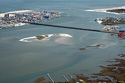
Sinepuxent Bay is an inland waterway which connects Chincoteague Bay to Isle of Wight Bay, and is connected to the Atlantic Ocean via the Ocean City Inlet. It separates Sinepuxent Neck, in Worcester County, Maryland from Assateague Island, and West Ocean City, Maryland from downtown Ocean City. Islands in the Sinepuxent Bay include Horn Island and Skimmer Island. It is crossed by the Harry W. Kelley Memorial Bridge on U.S. Route 50 and the Verrazano Bridge on Maryland Route 611. The bay is the location of the islands that compose the Sinepuxent Bay Wildlife Management Area. Historically the area was referred to by various names including Sinepuxent, Sene Puxon, Synepuxent, Cinnepuxon, et al.

Maryland Route 611 is a state highway in the U.S. state of Maryland. Known as Stephen Decatur Highway, the state highway runs 8.51 miles (13.70 km) from Assateague Island north to U.S. Route 50 in West Ocean City. MD 611 is named for Stephen Decatur, the U.S. naval officer of the early 19th century who was born in nearby Berlin. The state highway provides access to Assateague State Park and Assateague Island National Seashore via the Verrazano Bridge named for Giovanni da Verrazzano. MD 611 was first paved in West Ocean City in the mid-1930s. The highway was extended south to MD 376 at Lewis Corner in the 1940s. A ferry crossed Sinepuxent Bay to Assateague Island from the southern end of the county highway that continued south from Lewis Corner until MD 611 was extended across the Verrazano Bridge in the mid-1960s.

U.S. Route 13 (US 13) is a United States Numbered Highway running from Fayetteville, North Carolina, north to Morrisville, Pennsylvania. In the U.S. state of Maryland, the route runs 42.48 miles (68.36 km) from the Virginia border south of Pocomoke City in Worcester County north to the Delaware border in Delmar, Wicomico County, where the route intersects Maryland Route 54 (MD 54)/Delaware Route 54 (DE 54), which runs along the state line. The majority of the route within Maryland is a four-lane divided highway that passes through rural areas of woodland and farmland. The route also runs through a few municipalities including Pocomoke City and Princess Anne and it bypasses Fruitland and Salisbury to the east on the Salisbury Bypass, which is a freeway. US 13 intersects many major roads including the southern terminus of US 113 in Pocomoke City, MD 413 in Westover, and MD 12 and US 50 where the route is on the Salisbury Bypass. The route shares a concurrency with US 50 along a portion of the Salisbury Bypass.
Maryland Route 343 is a state highway in the U.S. state of Maryland. Known for most of its length as Hudson Road, the state highway runs 11.29 miles (18.17 km) from Hudson in northwestern Dorchester County east to U.S. Route 50 in Cambridge. MD 343 was paved in the late 1920s and early 1930s. The state highway originally passed through downtown Cambridge, ending just west of its present terminus. After the original Choptank River Bridge was completed in the mid-1930s, MD 343 was truncated to Sunburst Highway. In the mid-1950s, the state highway was rerouted along Washington Street to Race Street, where it ended at MD 16. Finally, MD 343 was extended to its present terminus when MD 16 bypassed Cambridge in the late 1960s.
Maryland Route 346 (MD 346) is a state highway in the U.S. state of Maryland. The state highway runs 23.72 miles (38.17 km) from U.S. Route 50 Business (US 50 Business) in Salisbury east to US 50 in Berlin. MD 346 is the old alignment of US 50 between Salisbury and Berlin, connecting those cities with Parsonsburg, Pittsville, and Willards in eastern Wicomico County and Whaleyville in northern Worcester County. Much of what is now MD 346 was built as the original state road between Salisbury and Ocean City in the mid-1910s. The highway was designated US 213 in 1927 and changed to US 50 in 1949. MD 346 was first applied to Church Street in Salisbury in the 1940s; this designation was removed in 1954. MD 346 was reassigned in the mid-1960s to the old alignments of US 50 left behind after US 50's bypass of Berlin opened in the late 1950s and the US 50 divided highway was completed between Salisbury and Berlin in the mid-1960s.
Maryland Route 12 is a state highway on the Eastern Shore in the U.S. state of Maryland. The route runs 30.57 mi (49.20 km) from the Virginia border south of Stockton, Worcester County, where it continues into Virginia as State Route 679, north to Main Street in the city of Salisbury in Wicomico County. The route is known as Snow Hill Road for most of its length and passes mostly through areas of woods and farms as well as the communities of Stockton, Girdletree, and Snow Hill. MD 12 intersects several roads including MD 366 in Stockton, U.S. Route 113 and US 113 Business in Snow Hill, MD 354 in Indiantown, and US 13 near Salisbury. Portions of MD 12 near Snow Hill and Stockton existed as unnumbered state roads by 1910. When the first state highways in Maryland were designated by 1927, MD 12 was assigned to run from Stockton north to Salisbury. By 1940, the route was extended south to the Virginia border and a small incomplete portion between Snow Hill and Salisbury was finished. A dumbbell interchange is planned at the US 113 intersection; however, this project is currently on hold.

U.S. Route 50 Business is a business route of U.S. Route 50 in the U.S. state of Maryland. The highway runs 6.88 miles (11.07 km) from US 50 on the northwest side of Salisbury to US 13 and US 50 on the east side of Salisbury in central Wicomico County. US 50 Business is a four- to six-lane divided highway within and on either side of the central business district of Salisbury, where the highway intersects MD 349, US 13 Business, and MD 346. US 50 Business west of MD 349 is a mid-1950s upgrade of the original highway entering Salisbury from the northwest. The business route between MD 349 and MD 346 was a relocation of US 50 from Main Street built in the early 1960s. East of MD 346, US 50 Business is part of the relocation of US 50 between Salisbury and Berlin completed in the mid-1960s. US 50 Business was designated when the US 50 portion of the Salisbury Bypass was completed in 2002.

Maryland Route 707 is a collection of state highways in the U.S. state of Maryland. These four highways are sections of the old alignment of U.S. Route 213 in northeastern Worcester County. These stretches of highway were bypassed and designated part of MD 707 in the early 1940s in West Ocean City and in the late 1940s in Grays Corner.

Maryland Route 818 is a state highway in the U.S. state of Maryland. Known as Main Street, the state highway runs 2.62 miles (4.22 km) between two intersections with U.S. Route 113 on the north and south sides of Berlin in Worcester County. MD 818 is the original 1927 alignment of US 113 through Berlin. The state highway was designated shortly after US 113's bypass of Berlin was completed in the late 1950s.