Worcester County is the easternmost county of the U.S. state of Maryland. As of the 2020 census, the population was 52,460. Its county seat is Snow Hill. The county is part of the Lower Eastern Shore region of the state.

Fenwick Island is a coastal resort town in Sussex County, Delaware, United States. According to 2020 census figures, the population of the town is 355, a 2.6% decrease over the last decade. It is part of the Salisbury, Maryland–Delaware Metropolitan Statistical Area. The town is located on Fenwick Island, a barrier spit.

Millville is a town in Sussex County, Delaware, United States. The population in 2020 was 1,825, It is part of the Salisbury, Maryland-Delaware Metropolitan Statistical Area and lies within Baltimore Hundred.

Ocean City, [oʊʃɪn sɪtiː] officially the Town of Ocean City, is an Atlantic resort town in Worcester County, Maryland, along the East Coast of the United States. The population was 6,844 at the 2020 U.S. census, although during summer weekends the city hosts between 320,000 and 345,000 vacationers and up to eight million visitors annually. During the summer, Ocean City becomes the second most populated municipality in Maryland, after Baltimore. It is part of the Salisbury metropolitan area as defined by the United States Census Bureau.

U.S. Route 50 or U.S. Highway 50 (US 50) is a major east–west route of the U.S. Highway system, stretching 3,019 miles (4,859 km) from Interstate 80 (I-80) in West Sacramento, California, to Maryland Route 528 in Ocean City, Maryland, on the Atlantic Ocean. Until 1972, when it was replaced by Interstate Highways west of the Sacramento area, it extended to San Francisco, near the Pacific Ocean. The Interstates were constructed later and are mostly separate from this route. It generally serves a corridor south of I-70 and I-80 and north of I-64 and I-40.
The Indian River is a river and estuary, approximately 15 mi (24 km) long, in Sussex County in southern Delaware in the United States. The river is named after a Native American reservation that was located on its upper reaches.

The Gov. William Preston Lane Jr. Memorial Bridge is a major dual-span bridge in the U.S. state of Maryland. Spanning the Chesapeake Bay, it connects the state's rural Eastern Shore region with its urban and suburban Western Shore, running between Stevensville and Sandy Point State Park near the capital city of Annapolis. The original span, opened in 1952 and with a length of 4 miles (6.4 km), was the world's longest continuous over-water steel structure. The parallel span was added in 1973. The bridge is named for William Preston Lane Jr., who as the 52nd Governor of Maryland launched its construction in the late 1940s after decades of political indecision and public controversy.

Maryland Route 213 (MD 213) is a 68.25-mile (109.84 km) state highway located on the Eastern Shore of Maryland in the United States. The route runs from MD 662 in Wye Mills, Queen Anne's County, north to the Pennsylvania border near Fair Hill in Cecil County, where the road continues into that state as Pennsylvania Route 841 (PA 841). The route, which is a two-lane undivided highway most of its length, passes through mainly rural areas as well as the towns of Centreville, Chestertown, Galena, Cecilton, Chesapeake City, and Elkton. MD 213 intersects many routes including U.S. Route 50 (US 50) near Wye Mills, US 301 near Centreville, and US 40 in Elkton. It crosses over the Chesapeake & Delaware Canal in Chesapeake City on the Chesapeake City Bridge. MD 213 is designated by the state as the Chesapeake Country Scenic Byway between the southern terminus and Chesapeake City with the portion north of MD 18 in Centreville a National Scenic Byway. In addition, the route is also considered part of the Atlantic to Appalachians Scenic Byway between Chesapeake City and MD 273 in Fair Hill.

Maryland Route 90 is a state highway in the U.S. state of Maryland. Known as the Ocean City Expressway, the state highway runs 11.83 miles (19.04 km) from U.S. Route 50 near Whaleyville east to MD 528 in Ocean City in Worcester County. MD 90 is a two-lane expressway that provides one of the main access routes to Ocean City, especially the northern part of the resort town, and thus sees heavy seasonal traffic. The highway was constructed from Ocean City starting in 1970. The state highway was opened west to MD 589 in 1972 and to US 113 in 1975. MD 90 was completed west to US 50 in 1976.
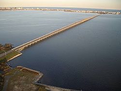
U.S. Route 50 is a major east–west route of the U.S. Highway system, stretching just over 3,000 miles (4,800 km) from West Sacramento, California, east to Ocean City, Maryland, on the Atlantic Ocean. In the U.S. state of Maryland, US 50 exists in two sections. The longer of these serves as a major route connecting Washington, D.C., with Ocean City; the latter is the eastern terminus of the highway. The other section passes through the southern end of Garrett County for less than 10 miles (16 km) as part of the Northwestern Turnpike, entering West Virginia at both ends. One notable section of US 50 is the dual-span Chesapeake Bay Bridge across the Chesapeake Bay, which links the Baltimore–Washington metropolitan area with the Eastern Shore region, allowing motorists to reach Ocean City and the Delaware Beaches.
Ocean Highway was a designation established early in the 20th century for a combination of roadways and water-crossings for motor vehicles which would generally traverse as close as possible to the Atlantic Ocean along the East Coast of the United States from Jacksonville, Florida to North Brunswick, New Jersey. The Ocean Highway concept predated the creation of the Interstate Highway System beginning in the 1950s, and in many states the highways and byways of coastal routes from Florida to North Brunswick still carry the name.

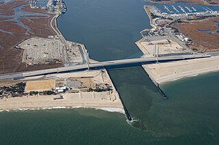
Sinepuxent Bay is an inland waterway which connects Chincoteague Bay to Isle of Wight Bay, and is connected to the Atlantic Ocean via the Ocean City Inlet. It separates Sinepuxent Neck, in Worcester County, Maryland from Assateague Island, and West Ocean City, Maryland from downtown Ocean City. Islands in the Sinepuxent Bay include Horn Island and Skimmer Island. It is crossed by the Harry W. Kelley Memorial Bridge on U.S. Route 50 and the Verrazano Bridge on Maryland Route 611. The bay is the location of the islands that compose the Sinepuxent Bay Wildlife Management Area. Historically the area was referred to by various names including Sinepuxent, Sene Puxon, Synepuxent, Cinnepuxon, et al.
Maryland Route 54 (MD 54) and Delaware Route 54 (DE 54) are adjoining state highways in the U.S. states of Maryland and Delaware. Route 54 runs 41.84 mi (67.33 km) from MD 313 in Mardela Springs, Maryland, east to DE 1 in Fenwick Island, Delaware. In addition to two segments in which the highway is completely in Delaware and two segments in which the highway is completely in Maryland, Route 54 follows the Delaware/Maryland state line between the twin towns of Delmar, Maryland, and Delmar, Delaware, and the highway's intersection with MD 353 and DE 26. One section of the state line portion of Route 54 is maintained by the Delaware Department of Transportation (DelDOT) while three sections of the highway that follow the state line are maintained by the Maryland State Highway Administration (MDSHA).

Assawoman Bay, once called Assawoman Sound, is a lagoon that is located between Ocean City, Maryland and mainland Delmarva. The bay is located on the northern end of the city, and the bay on the southern end is called the Isle of Wight Bay. The name "Assawoman Bay" comes from the Algonquian meaning "midway fishing stream".

Maryland Route 611 is a state highway in the U.S. state of Maryland. Known as Stephen Decatur Highway, the state highway runs 8.51 miles (13.70 km) from Assateague Island north to U.S. Route 50 in West Ocean City. MD 611 is named for Stephen Decatur, the U.S. naval officer of the early 19th century who was born in nearby Berlin. The state highway provides access to Assateague State Park and Assateague Island National Seashore via the Verrazano Bridge named for Giovanni da Verrazzano. MD 611 was first paved in West Ocean City in the mid-1930s. The highway was extended south to MD 376 at Lewis Corner in the 1940s. A ferry crossed Sinepuxent Bay to Assateague Island from the southern end of the county highway that continued south from Lewis Corner until MD 611 was extended across the Verrazano Bridge in the mid-1960s.

Delaware Route 26 (DE 26) is a state highway in Sussex County, Delaware. The route's western terminus is at an intersection with Maryland Route 353 (MD 353) and DE/MD 54 at the Maryland border south of Gumboro and its eastern terminus is at a dead end on the Atlantic Ocean in Bethany Beach, even though signage ends at the DE 1 intersection. The route passes through rural areas of southeastern Sussex County along with the communities of Dagsboro, Millville, Ocean View and Bethany Beach. DE 26 intersects DE 54 in the Gumboro area, U.S. Route 113 (US 113) and DE 20 in Dagsboro, and DE 17 west of Millville. The road was built as a state highway in various stages during the 1920s and 1930s. By 1936, DE 26 was assigned onto its current alignment.

Fenwick Island State Park is a 344-acre (139 ha) Delaware state park between Ocean City, Maryland and South Bethany, Delaware in Sussex County, Delaware, US. Fenwick Island State Park is open for year-round recreation from 8:00 am until sunset. Originally part of Delaware Seashore State Park, it was established in 1966 and renamed in 1981. The park is located on Fenwick Island, a narrow strip of land between the Atlantic Ocean and Little Assawoman Bay. It is largely undeveloped in comparison to the beach communities that surround it.
Isle of Wight Bay is a lagoon that separates part of mainland Worcester County, Maryland from the midtown part of Ocean City, also in Worcester County. To the north, it connects to the Assawoman Bay just south of the Assawoman Bay Bridge, and to the south it connects to the Sinepuxent Bay at the north end of West Ocean City where the bay narrows between the Thoroughfare channel and Mallard Island. The major tributary of Isle of Wight Bay is the St. Martin's River; other tributaries include Turville Creek, Manklin Creek, and Herring Creek.

Maryland Route 908 is a collection of unsigned state highways in Anne Arundel County in the U.S. state of Maryland. These five highways are service roads that parallel and provide access to U.S. Route 50 and US 301 along their western approach to the Chesapeake Bay Bridge; the highways also provide access to Sandy Point State Park. The first modern highway from Cape St. Claire to Skidmore was constructed in the late 1920s and replaced by the modern alignment of US 50 in the late 1940s. The frontage roads on either side of the U.S. Highway were constructed in the early 1950s. The mainline segments of MD 908 assumed their present form when US 50 and US 301 were upgraded to a freeway in the early 1990s.