Hart, North Dakota | |
|---|---|
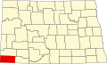
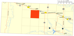 Location of Hart | |
| Coordinates: 46°09′44″N103°33′23″W / 46.16222°N 103.55639°W | |
| Country | United States |
| State | North Dakota |
| County | Bowman |
| Elevation | 3,133 ft (955 m) |
| Population (2010) | |
• Total | 25 |
| Time zone | UTC-7 (Mountain (MST)) |
| • Summer (DST) | UTC-6 (MDT) |
| Area code | 701 |
| GNIS feature ID | 1036082 [1] |
Hart is an unorganized territory in Bowman County in the U.S. state of North Dakota. As of the 2010 census, its population was 25. [2]