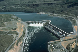
The Chief Joseph Dam is a concrete gravity dam on the Columbia River, 2.4 km (1.5 mi) upriver from Bridgeport, Washington. The dam is 877 km (545 mi) upriver from the mouth of the Columbia at Astoria, Oregon. It is operated by the USACE Chief Joseph Dam Project Office and the electricity is marketed by the Bonneville Power Administration.

Lake Oroville is a reservoir formed by the Oroville Dam impounding the Feather River, located in Butte County, northern California. The lake is situated 5 miles (8 km) northeast of the city of Oroville, within the Lake Oroville State Recreation Area, in the western foothills of the Sierra Nevada. Known as the second-largest reservoir in California, Lake Oroville is treated as a keystone facility within the California State Water Project by storing water, providing flood control, recreation, freshwater releases to assist in controlling the salinity intrusion into the Sacramento-San Joaquin Delta and protecting fish and wildlife.

Pine Flat Dam is a concrete gravity dam on the Kings River in the Central Valley of Fresno County, California United States. Situated about 28 miles (45 km) east of Fresno, the dam is 440 feet (130 m) high and impounds Pine Flat Lake, in the foothills of the Sierra Nevada just outside the boundary of Kings Canyon National Park. The dam's primary purpose is flood control, with irrigation, hydroelectric power generation and recreation secondary in importance.

Dworshak Dam is a concrete gravity dam in the western United States, on the North Fork of the Clearwater River in north central Idaho. In Clearwater County, the dam is located approximately four miles (6 km) northwest of Orofino and impounds the Dworshak Reservoir for flood control and hydroelectricity generation. By capacity, the reservoir is the largest in Idaho and fourth-largest in the Pacific Northwest.

Lake Qaraoun is an artificial lake or reservoir located in the southern region of the Beqaa Valley, Lebanon. It was created near Qaraoun village in 1959 by building a 61 m-high (200 ft) concrete-faced rockfill dam in the middle reaches of the Litani River. The reservoir has been used for hydropower generation, domestic water supply, and for irrigation of 27,500 ha.

Folsom Dam is a concrete gravity dam on the American River of Northern California in the United States, about 25 mi (40 km) northeast of Sacramento. The dam is 340 ft (100 m) high and 1,400 ft (430 m) long, flanked by earthen wing dams. It was completed in 1955, and officially opened the following year.

Terminus Dam is a dam on the Kaweah River in Tulare County, California in the United States, located near Three Rivers about 15 mi (24 km) from the western boundary of Sequoia National Park and 20 mi (32 km) east of Visalia. The dam forms Lake Kaweah for flood control and irrigation water supply. Completed by the U.S. Army Corps of Engineers (USACE) in 1962, Terminus is an earthfill dam 255 ft (78 m) high and 2,375 ft (724 m) long. The reservoir has a maximum capacity of 185,600 acre⋅ft (0.2289 km3) of water, although it usually sits at much lower levels.

Ujjani Dam, also known as Bhima Dam or Bhima Irrigation Project, on the Bhima River, a tributary of the Krishna River, is an earthfill cum Masonry gravity dam located near Ujjani village of Madha Taluk in Solapur district of the state of Maharashtra in India.

Canyon Ferry Dam is a concrete gravity dam in a narrow valley of the Missouri River, United States, where the Big Belt Mountains and the Spokane Hills merge, approximately 68 miles (109 km) downstream from the confluence of the Gallatin, Madison, and Jefferson rivers, and about 20 miles (32 km) east of the city of Helena, Montana. The dam is for flood control, irrigation, recreation and hydroelectric power. The building of the dam created a reservoir known as Canyon Ferry Lake.

J. Strom Thurmond Dam, also known in Georgia as Clarks Hill Dam, is a concrete-gravity and embankment dam located 22 miles (35 km) north of Augusta, Georgia on the Savannah River at the border of South Carolina and Georgia, creating Lake Strom Thurmond. U.S. Route 221 cross it. The dam was built by the U.S. Army Corps of Engineers between 1946 and 1954 for the purposes of flood control, hydroelectricity and downstream navigation. The concrete structure of the dam spans 1,096 feet (334 m) and rises 204 feet (62 m) above the riverbed, housing a power plant with an installed 380 MW capacity. The Dam has prevented over $3.1 million in estimated flood damage annually and also provides recreation, water quality, water supply, along with fish and wildlife management.

Richard B. Russell Dam is a concrete-gravity and embankment dam located on the Savannah River at the border of South Carolina and Georgia, creating Richard B. Russell Lake. The dam was built by the U.S. Army Corps of Engineers between 1974 and 1985 for the purposes of flood control, hydroelectricity, recreation, additional stream flow regulation, water supply, and fish and wildlife management. The concrete structure of the dam spans 1,904 feet (580 m) and rises 210 feet (64 m) above the riverbed, housing a hydro-power plant with an installed 600 megawatts (800,000 hp) capacity. The Richard B. Russell Dam is the final large dam completed by the U.S. Army Corps in the Savannah River Basin and lies 30 miles downstream from the Hartwell Dam (1962) and 37 miles (60 km) upstream from the J. Strom Thurmond Dam (1954).

Santa Fe Dam is a flood-control dam on the San Gabriel River located in Irwindale in Los Angeles County, California, United States. For most of the year, the 92-foot (28 m)-high dam and its reservoir lie empty, but can hold more than 45,000 acre-feet (56,000,000 m3) of water during major storms. During the dry season, the basin behind the dam is used for groundwater recharge, as well as various recreational activities.

The Fengman Dam is a concrete gravity dam 20 km (12 mi) from Jilin City on the Second Songhua River in Jilin Province, China. The main purposes of the dam are hydroelectric power generation and flood control. Construction of the dam began in 1937 and was complete in 1953. The dam is owned and operated by Northeast China Grid Company Limited.
The Jinanqiao Dam or Jin'anqiao Dam is a concrete gravity dam on the Jinsha River 25 km (16 mi) southeast of Lijiang City in Yunnan Province, China. The purpose of the dam is hydroelectric power production and flood control.
The Wanjiazhai Dam is a gravity dam on the Yellow River on the border of Pianguan County, Shaanxi Province and Inner Mongolia Autonomous Region, China. The main purpose of the dam is water supply for the Wanjiazhai Water Control Project along with peak hydroelectric power generation. Construction on the dam began in 1994, the first generator went online in 1998 and the last in 2000.

The Pensacola Dam, also known as the Grand River Dam, is a multiple-arch buttress dam located between the towns of Disney and Langley on the Grand River in Mayes County, Oklahoma. The dam is operated by the Grand River Dam Authority and creates Grand Lake o' the Cherokees. After decades of vision and planning, it was constructed between 1938 and 1940 for the purposes of hydroelectric power generation, flood control and recreation. It is Oklahoma's first hydroelectric power plant and is referred to as the longest multiple-arch dam in the world.
The Guxian Dam is a concrete gravity dam on the Luo River, a tributary of the Yellow River, in Luoning County, Henan Province, China. The primary purpose of the dam is flood control but it also generates hydroelectricity and provides water for irrigation. The 125 m (410 ft) tall dam withholds a reservoir of 1,175,000,000 m3 (952,588 acre⋅ft) and provides 848,000,000 m3 (687,485 acre⋅ft) in flood storage. The dam's power station contains three 20 MW Francis turbine-generators for a total installed capacity of 60 MW. Construction on the dam began in 1958 but was suspended several times afterwards. It recommenced in 1978 and the reservoir began to fill in 1991. The dam's generators were commissioned in 1992 and the project complete in 1993. The dam's spillway is controlled by five tainter gates and has a maximum discharge capacity of 11,436 m3/s (403,859 cu ft/s). Flip buckets are used at the spillway base to dissipate water. On the right side of the spillway there are two intermediate orifice openings controlled by hydraulic press-operated radial gates. Two bottom outlets are set on the spillway's left side, also controlled by hydraulic press-operated radial gates. To the left of the bottom outlets is the power station.
The Huanglongtan Dam is a concrete gravity dam located on the Du River, a tributary of the Han River. It is located 25 km (16 mi) west of Shiyan in Hubei Province, China. The main purpose of the dam is hydroelectric power generation but it also provides for flood control. It was constructed between 1969 and 1976 and support a 510 MW power station.
The Panjiakou Dam is a concrete gravity dam on the Luan River in Qianxi County, Hebei Province, China. The primary purpose of the dam is to provide water for the cities of Tianjin and Tangshan, located to the south. The dam also provides flood control and its power plant has an installed capacity of 420 MW which includes a 270 MW pumped storage power station.

Abiquiu Dam is a dam on the Rio Chama, located about 60 miles (97 km) northwest of Santa Fe in Rio Arriba County, New Mexico, USA. Built and operated by the U.S. Army Corps of Engineers (USACE), the dam is an earth embankment structure 354 feet (108 m) high and 1,800 feet (550 m) long, containing 11.8 million cubic yards of fill. The dam forms Abiquiu Lake, one of the largest lakes in New Mexico, with a full storage capacity of 1,369,000 acre-feet (1,689,000 dam3) and 5,200 acres (2,100 ha) of water. To date, the reservoir has never filled to capacity, with a record high of 402,258 acre-feet (496,178 dam3), 29.4% of full pool, on June 22, 1987. The dam's primary purpose is flood control, in addition to irrigation and municipal water storage, and hydroelectric generation.