
Killerby is a village in the borough of Darlington and the ceremonial county of County Durham, England. It is situated a few miles to the west of Darlington. Details are maintained in the parish of Staindrop.

Bolam is a small village located in County Durham, England. The village population at the 2011 census was 209. It is situated a few miles to the north-west of Darlington.

Hutton Magna is a village and civil parish in County Durham, England. Situated 7.6 miles (12.2 km) southeast of Barnard Castle. Lying within the historic boundaries of the North Riding of Yorkshire, the village along with the rest of the former Startforth Rural District has been administered by County Durham since 1 April 1974, under the provisions of the Local Government Act 1972. The civil parish also includes the hamlet of Lane Head.

Brignall is a village and civil parish in the south-west of County Durham, England. It is located in an elevated position adjacent to the River Greta, 1.2 miles (2 km) upstream from Greta Bridge. The nearest town is the market town of Barnard Castle.

Ovington is a village and civil parish in County Durham, England. Situated 8 miles (13 km) east of Barnard Castle. Lying within the historic boundaries of the North Riding of Yorkshire, the village along with the rest of the former Startforth Rural District has been administered with County Durham since 1 April 1974, under the provisions of the Local Government Act 1972.

Mickleton is a village and civil parish in Teesdale, County Durham, England, situated 8.5 miles (13.7 km) north west of Barnard Castle. Lying within the historic boundaries of the North Riding of Yorkshire, the village along with the rest of the former Startforth Rural District has been administered with County Durham since 1 April 1974, under the provisions of the Local Government Act 1972

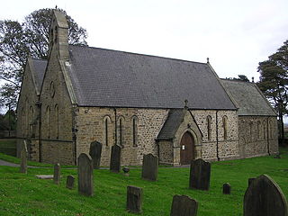
Ingleton is a village and civil parish in County Durham, England. The population of the parish as taken at the 2011 census was 420. It is situated about eight miles to the west of Darlington, and a short distance from the villages of Langton, Hilton and Killerby. The Church of St John the Evangelist in Ingleton was built in 1843 by Ignatius Bonomi and J.A. Cory., and is a Grade II listed building.
Cockfield is a village on the edge of Teesdale, County Durham, England. It is situated 8 miles to the south-west of Bishop Auckland, 15 miles (24 km) north-west of Darlington and 40 miles (64 km) south-west of Newcastle upon Tyne. Remains found on Cockfield Fell suggest there was a settlement in the area during the Iron Age. The parish church, dedicated to St Mary the Virgin, probably dates from the late 12th century.

Merrybent is a linear village in the civil parish of Low Coniscliffe and Merrybent in County Durham, in England. It is situated on the A67 road to the west of Darlington, a short distance to the north of the River Tees and the Teesdale Way. At the beginning of the 20th century there were hardly any buildings here, and its main feature at that time was Merrybent Nurseries with its many glasshouses. The nursery was cut through by the A1 road in the 1960s; at this point it runs on the trackbed of the old Merrybent railway. The village is now a settlement of modern housing.

Headlam is a village in the borough of Darlington and the ceremonial county of County Durham, England. It lies to the west of Darlington. The population taken at the 2011 Census was less than 100. Details are included in the parish of Ingleton. The hamlet has 14 stone houses plus 17th-century Headlam Hall, now a country house hotel. The village is set around a village green with a medieval cattle-pound and an old stone packhorse bridge across the beck. Headlam is classed as Lower Teesdale and has views to the south as far as Richmond and to the Cleveland Hills in the east.
Ettersgill is a village in County Durham, England. It is situated at the top of Teesdale, on the north side of the Tees between Newbiggin and Forest-in-Teesdale, and is in the civil parish of Forest and Frith. The village consists of scattered farms and farmhouses, centred on the fertile valley created by Etters Gill Beck, which flows from the mooorland into the Tees south of High Force.
Forest-in-Teesdale is a village in County Durham, England. It is situated in upper Teesdale, on the north side of the Tees between Newbiggin and Langdon Beck, and is in the civil parish of Forest and Frith.
Langdon Beck is a village in County Durham, England. It is situated in upper Teesdale, between Forest-in-Teesdale and Harwood, halfway between Penrith and Durham. It is in the civil parish of Forest and Frith. It is a stronghold for the black grouse, one of the few sites for them in the North of England.
Rookhope is a village in the civil parish of Stanhope, in County Durham, England. A former lead and fluorspar mining community, it first existed as a group of cattle farms in the 13th Century. It is situated in the Pennines to the north of Weardale. W. H. Auden once called Rookhope "the most wonderfully desolate of all the dales".

Wearhead is a village in the civil parish of Stanhope, in County Durham, England. It is situated at the top of Weardale between Cowshill and Ireshopeburn. It is named after the nearby source of the River Wear which runs eastwards for approx 40 miles (64 km) to Sunderland. In the 2001 census Wearhead had a population of 210.

Kentmere is a valley, village and civil parish in the Lake District National Park, a few miles from Kendal in the Westmorland and Furness district of Cumbria, England. Historically in Westmorland, at the 2011 census Kentmere had a population of 159. The current lord of the manor is American philanthropist Terry A. Perkins.

The Teesdale Way is a long-distance walk between the Cumbrian Pennines and the North Sea coast of North Yorkshire in England. The walk is 100 miles (160 km) in length; it links in with other long-distance walks such as the Pennine Way and the E2 European Walk between Harwich and Stranraer.
Lunedale is the dale, or valley, of the River Lune, on the east side of the Pennines in England, west of Middleton-in-Teesdale. Its principal settlements are Grassholme, Thringarth and Bowbank.

Deepdale, sometimes spelt Deep Dale, is a side valley of Teesdale in County Durham, England. In its lower reaches, just west of the town of Barnard Castle, the valley is well wooded, and is a nature reserve, known for its bird life and a population of otters. Deepdale Beck, a tributary of the River Tees, runs through the valley. By the beck is the Great Stone, a glacial erratic from Shap in Cumbria, one of the largest erratics in Teesdale.

Forest and Frith is a civil parish in the County Durham unitary authority, in the ceremonial county of Durham, England. In the 2011 census it had a population of 163.
