Hatten

Last updated • 2 min readFrom Wikipedia, The Free Encyclopedia
Hatten
Hatten.png
Location of Hatten within Oldenburg district
Hatten in OL.svgOldenburgHude
Germany adm location map.svg
Red pog.svg
Hatten
Lower Saxony location map.svg
Red pog.svg
Hatten
Coordinates: 53°00′30″N08°19′00″E / 53.00833°N 8.31667°E / 53.00833; 8.31667 Coordinates: 53°00′30″N08°19′00″E / 53.00833°N 8.31667°E / 53.00833; 8.31667
Country Germany
State Lower Saxony
District Oldenburg
Subdivisions17 districts
Government
   Mayor (202126) Guido Heinisch [1]
Area
  Total103.44 km2 (39.94 sq mi)
Elevation
34 m (112 ft)
Population
 (2021-12-31) [2]
  Total14,440
  Density140/km2 (360/sq mi)
Time zone UTC+01:00 (CET)
  Summer (DST) UTC+02:00 (CEST)
Postal codes
26209
Dialling codes 0 44 81,
0 44 82 (Hatten/Kirchhatten)
Vehicle registration OL
Website www.hatten.de

Hatten is a municipality in Oldenburg, in Lower Saxony, Germany. It is situated 16 km (9.94 mi) southeast of Oldenburg, on the North-West edge of the Wildeshausen Geest Nature Park.

Contents

Activities

Tourism endeavours emphasise the recreational and sporting opportunities available in the area. This includes, adjoining Kirchhatten, a large recreational centre, with swimming pool, exhibition and other facilities. Many visitors enjoy canoeing on the region's major river, the Hunte. The Hatten Airfield, Flugplatz Oldenburg-Hatten, is suitable for small aircraft. It also comprises a flight training school, and sightseeing flights can be booked there as well.

The region is serviced through an extensive public transport system, connecting with regional centres, with regular bus and train (NordWestBahn) schedules. These provide access to prominent tourist attractions, which in Sandkrug includes Blacksmith and Printing Museums. Moreover, Sandhatten features the workshop of well-known European artist Martin McWilliam, as well as ca. 6000-year-old stone graves.

Hatter Sprudel (Spring Water)

The name given to water attained from around the Osenberge, know to be one of the purest sources of spring water in all of Germany. It is entirely free of substantial bacteriological impurities, thus requiring the addition of no chlorine. Water from this source is sufficient to supply the needs of approximately 60 per cent of the greater Oldenburg area.

Stone Placement in Hatten Stone Placement in Hatten.jpg
Stone Placement in Hatten
Die Hunte in Hatten Die Hunte in Hatten.jpg
Die Hunte in Hatten
Forest Track in Hatten Forest Track in Hatten.JPG
Forest Track in Hatten
Agriculture in Hatten Agriculture in Hatten.JPG
Agriculture in Hatten

Municipal divisions

Hatten consists of the following divisions:

Neighbouring municipalities

Geography

History and heritage

Hatten, or its internal division of Kirchhatten, was first attributed the name of "Hatho" in 860 AD. Derived from the Germanic dialects of Hathus or Hadu, the word may be loosely interpreted to relate to "War", "God of War" or "Fortunate Warrior".

Country Road and Field in Hatten Country Road and Field in Hatten.jpg
Country Road and Field in Hatten
Further Agriculture in Hatten Further Agriculture in Hatten.JPG
Further Agriculture in Hatten

Tacks from hunters exist from the Stone Age, as well as those of later Germanic tribes and saxons. Settlements are known to have developed in the region partially as a result of abundance of fruitful agricultural lands.

Coat of arms

a) The dual fir trees may be regarded as an entrance; also, as a representation of the abundantly forested land
b) The centrally located shield is used to represent the historically-connected ownership of the area to the Oldenburger count
c) The stylised rose located in the upper portion is indicative of attributes of the land itself. Moreover, it may be traced to the oldest coat of arms of Oldenburg-Wildeshausen.

Sons and daughters

Related Research Articles

<span class="mw-page-title-main">Lower Saxony</span> State in Germany

Lower Saxony is a German state in northwestern Germany. It is the second-largest state by land area, with 47,614 km2 (18,384 sq mi), and fourth-largest in population among the 16 Länder federated as the Federal Republic of Germany. In rural areas, Northern Low Saxon and Saterland Frisian are still spoken, albeit in declining numbers.

<span class="mw-page-title-main">Oldenburg (city)</span> City in Lower Saxony, Germany

Oldenburg is an independent city in the state of Lower Saxony, Germany. The city is officially named Oldenburg (Oldb) to distinguish from Oldenburg in Holstein.

<span class="mw-page-title-main">Cloppenburg (district)</span> District in Lower Saxony, Germany

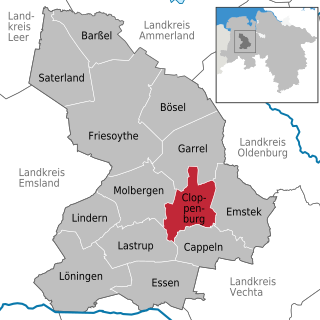
Cloppenburg is a district in Lower Saxony, Germany. It is bounded by the districts of Ammerland, Oldenburg, Vechta, Osnabrück, Emsland and Leer.

The district of Oldenburg is a district in the state of Lower Saxony, Germany. It is bounded by the districts of Diepholz, Vechta, Cloppenburg and Ammerland, the city of Oldenburg, the district of Wesermarsch and the city of Delmenhorst.

Vechta is a district (Landkreis) in Lower Saxony, Germany. It is bounded by the districts of Oldenburg, Diepholz, Osnabrück and Cloppenburg.

<span class="mw-page-title-main">Wildeshausen</span> Town in Lower Saxony, Germany

Wildeshausen is a town and the capital of the Oldenburg district in Lower Saxony, Germany. It is situated by the river Hunte.

<span class="mw-page-title-main">Saterland</span> Municipality in Lower Saxony, Germany

Saterland is a municipality in the district of Cloppenburg, in Lower Saxony, Germany. It is situated between the cities of Leer, Cloppenburg, and Oldenburg. It is home to Saterland Frisians, who speak Frisian in addition to German.

<span class="mw-page-title-main">Großenkneten</span> Municipality in Lower Saxony, Germany

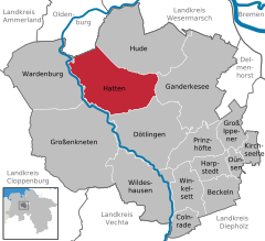
Großenkneten is a municipality in the district of Oldenburg, in Lower Saxony, Germany.

<span class="mw-page-title-main">Cloppenburg</span> Town in Lower Saxony, Germany

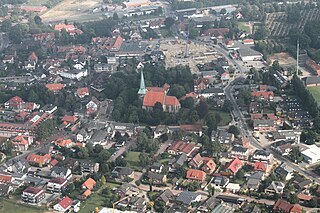
Cloppenburg is a town in Lower Saxony, Germany, capital of Cloppenburg District and part of Oldenburg Münsterland. It lies 38 km south-south-west of Oldenburg in the Weser-Ems region between Bremen and the Dutch border. Cloppenburg is not far from the A1, the major motorway connecting the Ruhr area to Bremen and Hamburg. Another major road is the federal highway B213 being the shortest link from the Netherlands to the A1 and thus to Bremen and Hamburg.

<span class="mw-page-title-main">Ganderkesee</span> Municipality in Lower Saxony, Germany

Ganderkesee is a municipality in Oldenburg district, in Lower Saxony, Germany.

<span class="mw-page-title-main">Hude, Lower Saxony</span> Municipality in Lower Saxony, Germany

Hude is a municipality in the district of Oldenburg, in Lower Saxony, Germany. It is situated 15 km east of Oldenburg, and 25 km west of Bremen (centre). The population is approximately 15,000 and approximately one third of these people are retired.

<span class="mw-page-title-main">Elsfleth</span> Town in Lower Saxony, Germany

Elsfleth is a town in the district of Wesermarsch, Lower Saxony, Germany. It is situated at the confluence of the Hunte with the Weser, on the left bank of the Weser. It has a school of navigation, a harbour and docks.

<span class="mw-page-title-main">Westerstede</span> Town in Lower Saxony, Germany

Westerstede is the capital of the Ammerland district, in Lower Saxony, Germany. It is situated approximately 25 km northwest of Oldenburg.

<span class="mw-page-title-main">Rastede</span> Municipality in Lower Saxony, Germany

Rastede is a municipality in the Ammerland district, in Lower Saxony, Germany. It is situated approximately 12 km north of Oldenburg. It is the site of the Schloss Rastede.

<span class="mw-page-title-main">Dötlingen</span> Municipality in Lower Saxony, Germany

Dötlingen is a municipality in the district of Oldenburg, in Lower Saxony, Germany. It is situated approximately 6 km northeast of Wildeshausen, and 25 km southeast of Oldenburg at the Hunte river. It's one of Germany's richest villages. The Nazis gave Dötlingen the title "Musterdorf von Deutschland", which means "Best village in Germany". In Dötlingen are many stone graves, and some plants and animals only exist there. Dötlingen was two times "Schönstes Dorf Deutschlands", the most beautiful village of Germany. Even if it is a beautiful place, Dötlingen is not known very much and has even in German language a very strange name. The oak tree in the middle of Dötlingen, next to the old church made of cobble stone, is over 1000 years old. The oak tree was struck by lightning and burst, but it survived.

<span class="mw-page-title-main">Neuenkirchen-Vörden</span> Municipality in Lower Saxony, Germany

Neuenkirchen-Vörden is a municipality in the district of Vechta, in Lower Saxony, Germany. It is situated approximately 30 km southwest of Vechta, and 30 km north of Osnabrück.

<span class="mw-page-title-main">Visbek</span> Municipality in Lower Saxony, Germany

Visbek is a municipality in the district of Vechta, in the Oldenburg Münsterland region of the state of Lower Saxony, Germany.

<span class="mw-page-title-main">Jade, Germany</span> Municipality in Lower Saxony, Germany

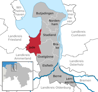
Jade is a municipality in the district of Wesermarsch, in Lower Saxony, Germany. It is situated on the river Jade, approx. 23 km (14 mi) north of Oldenburg, and 50 km (31 mi) northwest of Bremen.

<span class="mw-page-title-main">Ovelgönne</span> Municipality in Lower Saxony, Germany

Ovelgönne is a municipality in the district of Wesermarsch, in Lower Saxony, Germany. It is situated approximately 27 km northeast of Oldenburg, and 40 km northwest of Bremen. The municipality of Ovelgönne has its administration in the village of Oldenbrok and not in the homonymous village of Ovelgönne.

<span class="mw-page-title-main">Osenberge</span>

The Osenberge is a dune region up to 23 m above sea level (NN) high in the district of Oldenburg, Lower Saxony (Germany).

References

  1. "Stichwahlen zu Direktwahlen in Niedersachsen vom 26. September 2021" (PDF). Landesamt für Statistik Niedersachsen. 13 October 2021.
  2. "LSN-Online Regionaldatenbank, Tabelle A100001G: Fortschreibung des Bevölkerungsstandes, Stand 31. Dezember 2021" (in German). Landesamt für Statistik Niedersachsen.