
A megalith is a large stone that has been used to construct a prehistoric structure or monument, either alone or together with other stones. There are over 35,000 in Europe alone, located widely from Sweden to the Mediterranean sea.

A tumulus is a mound of earth and stones raised over a grave or graves. Tumuli are also known as barrows, burial mounds or kurgans, and may be found throughout much of the world. A cairn, which is a mound of stones built for various purposes, may also originally have been a tumulus.

Arbor Low is a well-preserved Neolithic henge in the Derbyshire Peak District, England. It lies on a Carboniferous Limestone plateau known as the White Peak area. The monument consists of a stone circle surrounded by earthworks and a ditch.

A stone circle is a circular alignment of standing stones. They are commonly found across Northern Europe and Great Britain, and typically date from the Late Neolithic and Early Bronze Age eras, with most concentrations appearing from 3000 BC. The best known examples include those at the henge monument at Avebury, the Rollright Stones, and elements within the ring of standing stones at Stonehenge. Ancient stone circles appear throughout Europe, with many existing in the Pyrenees, on the Causse de Blandas in southern France in the Cevennes, in the Alps, and Bulgaria.

Kokino is a Bronze Age archaeological site in the Republic of North Macedonia, approximately 30 km from the town of Kumanovo, and about 6 km from the Serbian border, in the Staro Nagoričane Municipality. It is situated between about 1010 and 1030 m above sea level on the Tatićev Kamen summit and covers an area of about 90 by 50 meters, overlooking the eponymous hamlet of Kokino.
This article describes several characteristic architectural elements typical of European megalithic structures.

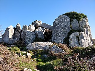
Boskednan stone circle is a partially restored prehistoric stone circle near Boskednan, around 4 miles northwest of the town of Penzance in Cornwall, United Kingdom. The megalithic monument is traditionally known as the Nine Maidens or Nine Stones of Boskednan, although the original structure may have contained as many as 22 upright stones around its 69-metre perimeter.

Concentrations of megaliths, dolmens and stone labyrinths dating between the end of the 4th millennium and the beginning of the 2nd millennium B.C. have been found throughout the Caucasus Mountains, including Abkhazia. Most of them are represented by rectangular structures made of stone slabs or cut in rocks with holes in their facade. These dolmens cover the Western Caucasus on both sides of the mountain ridge, in an area of approximately 12,000 square kilometres of Russia and Abkhazia.
The Lancken-Granitz dolmens are a group of seven megalith tombs in the Lancken-Granitz municipality on Rügen, northern Germany. Erected during the middle Neolithic, when they were used by the Funnelbeaker culture, at least some were in use until the early Bronze Age. Three of them are encircled by solitary rocks forming either rectangles or a stone circle, one has a solitary "guardian stone" on its eastern side.

In the area of present-day Mecklenburg-Vorpommern, Germany, up to 5,000 megalith tombs were erected as burial sites by people of the Neolithic Funnelbeaker (TRB) culture. More than 1,000 of them are preserved today and protected by law. Though varying in style and age, megalith structures are common in Western Europe, with those in Mecklenburg-Vorpommern belonging to the youngest and easternmost—further east, in the modern West Pomeranian Voivodeship of Poland, monuments erected by the TRB people did not include lithic structures, while they do in the south (Brandenburg), west and north (Denmark).

The Cromlech of the Almendres is a megalithic complex, located 4.5 road km WSW of the village of Nossa Senhora de Guadalupe, in the civil parish of Nossa Senhora da Tourega e Nossa Senhora de Guadalupe, municipality of Évora, in the Portuguese Alentejo. The largest existing group of structured menhirs in the Iberian Peninsula, this archaeological site consists of several megalithic structures: cromlechs and menhir stones, that belong to the so-called "megalithic universe of Évora", with clear parallels to other cromlechs in Évora District, such as Portela Mogos and the Vale Maria do Meio Cromlech.
The Bramgau is the historic name for the region of settlement around the independent municipality of Bramsche in the north of the district of Osnabrück in the German federal state of Lower Saxony. with megalithic tombs and tumuli from the New Stone Age and Bronze Age. It lies within the TERRA.vita Nature and Geopark.

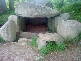
Nordic megalith architecture is an ancient architectural style found in Northern Europe, especially Scandinavia and North Germany, that involves large slabs of stone arranged to form a structure. It emerged in northern Europe, predominantly between 3500 and 2800 BC. It was primarily a product of the Funnelbeaker culture. Between 1964 and 1974, Ewald Schuldt in Mecklenburg-Western Pomerania excavated over 100 sites of different types: simple dolmens, extended dolmens, passage graves, great dolmens, unchambered long barrows, and stone cists. In addition, there are polygonal dolmens and types that emerged later, for example, the Grabkiste and Röse. This nomenclature, which specifically derives from the German, is not used in Scandinavia where these sites are categorised by other, more general, terms, as dolmens, passage graves and stone cists . Neolithic monuments are a feature of the culture and ideology of Neolithic communities. Their appearance and function serves as an indicator of their social development.

The simple dolmen or primeval dolmen is an early form of dolmen or megalithic tomb that occurs especially in Northern Europe. The term was defined by archaeologist, Ernst Sprockhoff, and utilised by Ewald Schuldt in publicising his excavation of 106 megalithic sites in the north German state of Mecklenburg-Vorpommern. The simple dolmen emerged in the early days of the development of megalithic monuments of the Funnelbeaker culture (TBK) and around 3,500 BC they appeared across almost the entire region covered by the stone cult structures of Nordic megalith architecture, but not in the Netherlands, in Lower Saxony west of the River Weser nor east of the River Oder and only once in Sweden.

The unchambered long barrowearthen long barrow, non-megalithic long barrow or non-megalithic mound, is a type of long barrow found across the British Isles, in a belt of land in Brittany, and in northern Europe as far east as the River Vistula. The term "unchambered" means that there is no stone chamber within the stone enclosure. In Great Britain they are often known as non-megalithic long barrows or unchambered long cairns.

The Route of Megalithic Culture was first created as a tourist route that meanders from Osnabrück to Oldenburg in North-West Germany. Signposted with brown road signs it links many places of archaeological interest from the Megalithic era.
Darum/Gretesch/Lüstringen is a district of the city of Osnabrück, Lower Saxony, Germany. It is situated in the east of the city and is made up of these three localities, as well as land from within the former boundaries of Schinkel. It is home to a Protestant and a Catholic church – respectively the Petruskirche and the Marienkirche. There also used to be a railway station in this district – Osnabrück-Lüstringen, which was located on the Osnabrück–Hannover line and operated until 1978. The district is situated on the Route of Megalithic Culture.
The Anta de Adrenunes, located on top of a hill at 426 metres above sea level, in the municipality of Sintra, within Sintra-Cascais Natural Park, Lisbon District, Portugal, is believed to be a Stone Age burial chamber or megalithic monument. It is a structure consisting of a cluster of granite stones, between which there is a gallery about 5 metres high that is surmounted by monoliths that rest horizontally on vertical stones. The passage is thought to have served as a collective necropolis or dolmen during the megalithic period although no artifacts or burial chambers have been found to prove this. The site contains a geodesic landmark that has been inserted into one of the upper stones.

The Anta da Vidigueira is a megalithic dolmen or burial chamber located southwest of the village of Freixo, in Redondo municipality in the Évora district of the Alentejo region of Portugal. The dolmen was probably constructed between the Neolithic and the Chalcolithic. It has been classified as a National Monument since 1910.


