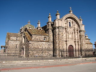
Lampa province is a province of the Puno region in Peru. Its population is about 40,856. The capital is Lampa.

Quispicanchi Province is one of thirteen provinces in the Cusco Region in the southern highlands of Peru.

Melgar Province is a province of the Puno Region in Peru. The capital of the province is the city of Ayaviri.
Palca District is one of ten districts of the province Lampa in Peru.
Paratia District is one of ten districts of the province Lampa in Peru.
Nuñoa District is one of nine districts of the Melgar Province in Peru.

Kunka is a mountain in the La Raya mountain range in the Andes of Peru. It is situated at the La Raya Pass and the road and rail which connect Cusco with Lake Titicaca. It is located in the Cusco Region, Canas Province, Layo District, and in the Puno Region, Melgar Province, Santa Rosa District, and about 5,200 metres (17,060 ft) high. Kunka lies southwest of the mountains Yana Khuchilla and Chimpulla. Other neighboring mountains are Huch'uy K'uchu north of it and Hatun Ichhuna Kunka in the south. Between the road and the mountain there is a little lake named Q'umirqucha.
Hatun Tipiqucha is a lake in Peru located in the Ayacucho Region, Paucar del Sara Sara Province, Oyolo District. It lies south of the lakes Tipiqucha and Huch'uy Tipiqucha, and northeast of the lakes Yanaqucha and Kunturqucha.
Huch'uy Tipiqucha is a lake in Peru located in the Ayacucho Region, Paucar del Sara Sara Province, Oyolo District. It lies between the lakes Tipiqucha in the north and Hatun Tipiqucha in the south, northeast of the lakes Yanaqucha, Kunturqucha and Chawpi Tipiqucha.

Yanawara or Mina Punta is a mountain in the Andes of Peru, about 5,465 metres (17,930 ft) high. It is located in the Puno Region, Lampa Province, on the border of the districts Palca and Paratía. Yanawara lies northwest of the lake Sayt'uqucha.

Qillqa is a mountain in the Andes of Peru, about 5,350 metres (17,552 ft) high. It is located in the Puno Region, Lampa Province, on the border of the districts Palca and Paratía. Qillqa lies northwest of the mountains Yanawara, Waykira and Hatun Pastu.

Jatuncucho is a mountain in the Vilcanota mountain range in the Andes of Peru, about 5,400 metres (17,717 ft) high. It is situated in the Cusco Region, Canchis Province, San Pablo District, in the Puno Region, Carabaya Province, Corani District, and in the Melgar Province, Nuñoa District. Jatuncucho lies between Pomanota in the north-west and Jonorana in the east and north-east of the mountain Cochacucho.

Jatun Sallica is a mountain in the Vilcanota mountain range Andes of Peru, about 5,200 metres (17,060 ft) high. It is located in the Cusco Region, Canchis Province, San Pablo District, and in the Puno Region, Melgar Province, Nuñoa District. Jatun Sallica is situated south-west of the mountains Pomanota and Jatuncucho, south of the mountain Cochacucho and north-east of the mountain Hueco.

Waykira is a mountain in the Andes of Peru, about 5,200 metres (17,060 ft) high. It is located in the Puno Region, Lampa Province, on the border of the districts Palca and Paratía. Waykira lies southeast of the mountain Qillqa and south of Hatun Pastu.

Chuqi Pirwa is a mountain in the Andes of Peru, about 5,200 m (17,100 ft) high. It is situated in the Cusco Region, Espinar Province, Condoroma District, and in the Puno Region, Lampa Province, Ocuviri District. Chuqi Pirwa lies southwest of Sawanani Lake (Saguanani) and northwest of Qullqi Q'awa.

Wilaquta is a mountain in the Peruvian Andes, about 5,100 metres (16,732 ft) high. It is situated in the Moquegua Region, Mariscal Nieto Province, Carumas District, and in the Puno Region, Puno Province, Acora District. Wilaquta lies north of the lake Aqhuyach'alla and southeast of the mountain Qurini.

Hatun Qurini is a mountain in the Peruvian Andes, about 5,000 metres (16,404 ft) high. It is situated in the Puno Region, Azángaro Province, San José District. Hatun Qurini lies northwest of the mountain Surupana.

Jatun Quenamari is a mountain in the Vilcanota mountain range in the Andes of Peru, about 5,400 metres (17,717 ft) high. It is situated in the Puno Region, Carabaya Province, Corani District. Jatun Quenamari lies east of the large glaciated area of Quelccaya, southwest of Cuncunani.

Hatun Ichhuna Kunka is a mountain in the La Raya mountain range in the Andes of Peru, about 5,000 metres (16,404 ft) high. It is located in the Cusco Region, Canas Province, Layo District, and in the Puno Region, Melgar Province, Santa Rosa District. Hatun Ichhuna Kunka lies near the La Raya pass southwest of Kunka. Huch'uy Ichhuna Kunka and Pichaqani are the lower elevations of the ridge to the northwest.

Yana Ranra is a mountain in the La Raya mountain range in the Andes of Peru, about 5,000 metres (16,404 ft) high. It is located in the Cusco Region, Canas Province, Layo District, and in the Canchis Province, Marangani District. Yana Ranra lies near the La Raya pass northwest of Chimpulla and Kunka and southwest of Huch'uy K'uchu. It is situated at the Hatun K'uchu valley whose stream flows to the Willkanuta River.


