
Vinje is a municipality in Telemark county, Norway. It is located in the traditional district of Vest-Telemark which is part of Øvre Telemark. The administrative centre of the municipality is the village of Åmot. Other villages in the municipality include Arabygdi, Edland, Grunge, Haukeli, Krossen, Møsstrond, Nesland, Øyfjell, Raulandsgrend, and Vinje.

The Pilgrim's Route, (Pilegrimsleden) also known as St. Olav's Way or the Old Kings' Road, was a pilgrimage route to the Nidaros Cathedral in Trondheim, Norway, the site of the medieval tomb of St. Olav. The main route is approximately 640 kilometres (400 mi) long. It starts in the ancient part of Oslo and heads north along the lake Mjøsa, up the Gudbrandsdal valley, over the Dovrefjell mountains, and down the Oppdal and Gauldalen valleys to end at the Nidaros Cathedral.

Oberalp Pass is a high mountain pass in the Swiss Alps connecting the cantons of Graubünden and Uri between Disentis/Mustér and Andermatt.

European route E134 is a European highway that crosses Norway starting at Haugesund Airport, Karmøy near the city of Haugesund on the west coast, heading over Haukeli, passing the city of Drammen, and ending in Vassum on the east side of the Oslofjord Tunnel.

The Folgefonna Tunnel is a 11,150-meter (36,580 ft) long road tunnel in Vestland county, Norway. The tunnel connects the village of Eitrheim and the town of Odda at the head of Sørfjorden in Ullensvang Municipality to the village of Austrepollen at the head of Maurangsfjorden in Kvinnherad municipality. The tunnel runs under the large Folgefonna glacier and Folgefonna National Park. The tunnel opened in 2001 and is Norway's fourth longest road tunnel. It reduced travel time between these two places from four hours all the way down to ten minutes. It is part of County Road 49.

Snoqualmie Pass is a mountain pass that carries Interstate 90 (I-90) through the Cascade Range in the U.S. state of Washington. The pass summit is at an elevation of 3,015 feet (919 m), on the county line between Kittitas County and King County.
National Road 13 is a national road which runs from the town of Stavanger in Rogaland county to the village of Sogndalsfjøra in Vestland county. The route is 449.9 kilometers (279.6 mi) long and runs south–north through Rogaland and Vestland counties, following a more inland path than the European route E39 highway.

Norwegian National Road 9 is often called the Setesdal Road and it is the main thoroughfare through the Setesdalen valley. It runs from the city of Kristiansand in the southern coast of Norway, through the Torridal and Setesdal valleys in Agder county to Haukeligrend in Telemark county in the north where it meets the European route E134 highway. The highway goes through the villages of Mosby, Homstean, Skarpengland, Hægeland, Hornesund, Hornnes, Evje, Byglandsfjord, Bygland, Ose, Rysstad, Valle, Flatland, Rygnestad, Bykle, Hovden, Bjåen, and Haukeli.

Haukeli is a village in Vinje Municipality in Telemark county, Norway. The village is located up in the Haukelifjell mountains, just south of the Hardangervidda National Park and immediately west of the village of Edland. Haukeli is where Norwegian National Road 9 and European route E134 meet. It is the last larger village heading west before going over the mountain pass and entering Western Norway. Prior to 1999, the area was called Haukeligrend.

Old Dyrskartunnel is a road tunnel in Odda municipality in Hordaland county, Norway. The tunnel was built in 1900 and is one of the oldest road tunnels in Norway. Earlier, the main road over the mountains between Haugesund in Vestlandet and Østlandet went through the tunnel. The current European route E134 pass through the newer Haukeli tunnel in a parallel corridor. The Old Dyreskartunnel is located on the slope above the current tunnel.

The Austmannali Tunnel is a road tunnel in Ullensvang Municipality in Vestland county, Norway. The 903-metre (2,963 ft) long tunnel is part of the European route E134 highway as it goes up the Austmannlia mountain. The tunnel is located just south of the lake Valldalsvatnet, about 5 kilometres (3.1 mi) northeast of the village of Røldal. The tunnel was built in 1982 to replace a steep section of the highway that was built in 1880 which had a road grade of 8.3% and included five sharp hairpin turns. The new tunnel is wider than the old road and it is one large horseshoe curve with a steady increase in elevation through the whole tunnel.

The Røldal Tunnel is a road tunnel in Ullensvang Municipality in Vestland county, Norway. The 4,657-metre (15,279 ft) tunnel is part of the European route E134 highway and it connects the village of Horda in the Røldal area with the Seljestad area on the other side of the mountains to the west. The tunnel was opened on 21 February 1964 and for four years after its opening, it was the longest road tunnel in Norway. The Seljestad Tunnel is located 275 metres (902 ft) west of the entrance to the Røldal Tunnel.

The Haukeli Tunnel is a road tunnel in Ullensvang Municipality in Vestland county, Norway. The 5,682-metre (3.531 mi) tunnel is located about 10 kilometres (6.2 mi) northeast of the village of Røldal. This tunnel was the longest tunnel in Norway from 1968 until the Høyanger Tunnel was opened in 1982. In 2007, the tunnel was renovated and the interior height was increased to 4.2 metres (14 ft) throughout the tunnel.
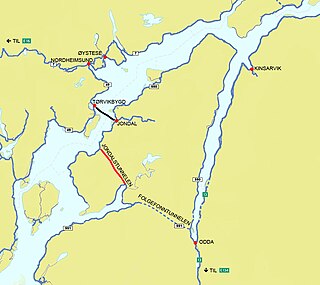
The Jondal Tunnel is a road tunnel in the Hardanger region of Vestland county, Norway. The tunnel is part of Norwegian County Road 49 and it lies in Kvinnherad and Ullensvang municipalities. The 10.4-kilometre (6.5 mi) long tunnel was built to offer a better route between the cities of Bergen and Oslo. Cars can drive from Bergen to Tørvikbygda, then take a ferry to Jondal, then go through this tunnel, then a short drive to the Folgefonna Tunnel before getting to the town of Odda. From there it is a short drive on the narrow route 13 to the European route E134 highway which leads to Oslo.

The Rullestad Tunnel is a road tunnel in Etne municipality in Vestland county, Norway. The 2,920-metre (9,580 ft) long tunnel is located on the European route E134 highway, about 4 kilometres (2.5 mi) east of the village of Fjæra and about 9 kilometres (5.6 mi) southwest of the village of Skare in neighboring Ullensvang municipality. The tunnel opened on 30 June 2006 to replace a narrow, winding mountain road that included some hairpin turns. The new tunnel has a maximum grade of 6.6%.

The Fjæra Tunnel is a road tunnel in Etne municipality in Vestland county, Norway. The 1,518-metre (4,980 ft) long tunnel is located on the European route E134 highway, just southwest of the village of Fjæra. The tunnel was built in 1992 to replace the narrow, winding road that ran between the shore of the Åkrafjorden and the base of the steep mountains.

The Åkrafjord Tunnel is a road tunnel in Etne municipality in Vestland county, Norway. The 7,404-metre (4.6 mi) long tunnel is located on the European route E134 highway, on the southeastern side of the Åkrafjorden, about 15 kilometres (9.3 mi) northeast of the village of Etnesjøen. The tunnel was opened on 15 July 2000 to replace a narrow and winding road on the narrow shoreline between the fjord and the steep mountainsides.

The Markhus Tunnel is a road tunnel in Etne municipality in Vestland county, Norway. The 2,405-metre (7,890 ft) long tunnel is located on the European route E134 highway on the southern shore of the Åkrafjorden, about 10 kilometres (6.2 mi) southwest of the village of Fjæra. The tunnel was opened in 1995 to replace a narrow, winding road that goes through a small residential area. The tunnel gave a wider, straighter road that meets official standards for highways.
Kvænangsfjellet is a line of mountains along the border of Kvænangen Municipality and Nordreisa Municipality in Troms county, Norway. The European route E6 highway traverses the mountains through a mountain pass between the Oksfjorden in the west to the Kvænangen fjord in the east. In the winter, route E6 is closed for 10 to 15 days due to snow storms. A short stretch of the route is exposed to the weather, a gap near the route's highest point, at 402 meters (1,319 ft). During the Second World War, the German occupation authorities built a wooden superstructure approximately 6 kilometers (3.7 mi) long using labor from the Veidal Prison Camp to protect the route. The structure was destroyed in scorched earth tactics when the Germans withdrew to the south in 1944.

The Mælefjell Tunnel is a 9.35-kilometre-long (5.81 mi) road tunnel along the European route E134 highway in Telemark county, Norway. The southern end of the tunnel is located at Århus on the north side of the village of Seljord in Seljord Municipality. The northern end of the tunnel is at Gvammen, just east of the village of Hjartdal in Hjartdal Municipality. The tunnel was opened on 19 December 2019, as Norway's seventh longest road tunnel. It is part of the European route E134 highway, and upon its completion, it made the highway about 10 kilometres (6.2 mi) shorter, saving trucks about 18 minutes of driving time between those two places. Construction started in 2013 and the breakthrough occurred on 3 May 2017.


