Haulerwijk Haulerwyk | |
|---|---|
Village | |
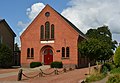
 Haulerwijk Church | |
 Coat of arms | |
 Location in Ooststellingwerf municipality | |
 Haulerwijk Location in the Netherlands  Haulerwijk Haulerwijk (Netherlands) | |
| Coordinates: 53°3′55″N6°19′53″E / 53.06528°N 6.33139°E | |
| Country | |
| Province | |
| Municipality | |
| Area | |
• Total | 10.38 km2 (4.01 sq mi) |
| Elevation | 7 m (23 ft) |
| Population (2021) [1] | |
• Total | 3,220 |
| • Density | 310/km2 (800/sq mi) |
| Postal code | 8433 [1] |
| Dialing code | 0516 |
Haulerwijk (West Frisian : Haulerwyk) is a village in the municipality of Ooststellingwerf in the east of Friesland, the Netherlands. In 2017, it had a population of around 3,300. [3]
The village was first mentioned in 1844 as Haulerwijk, and means "canal of Haule". [4] Haulerwijk started as a peat colony of the Drachtster Company along the Haulerwijkstervaart which was dug 1756. The Dutch Reformed church dates from 1852. [5] In 1840, Haulerwijk was home to 69 people. [6]