Demographics
Based on the 2007 Census conducted by the CSA, this woreda has a total population of 124,472, of whom 62,774 are men and 61,698 women; none of its population are urban dwellers. The majority of the inhabitants were Protestants, with 85.82% of the population reporting that belief, 6.67% were Muslim, and 5.61% were Catholic. [2]
In the 1994 Census this woreda had a population of 345,526, of whom 176,406 were men and 169,120 women; 72,366 or 20.94% of its population were urban dwellers. The five largest ethnic groups reported in Hawassa were the Sidama (67.47%), the Oromo (10.17%), the Amhara (8.86%), the Welayta (6.91%), and the Kambaata (2.03%); all other ethnic groups made up 4.56% of the population. Sidaamu Afoo is spoken as a first language by 69.74% of the inhabitants, 15.67% speak Amharic, 6.48% Oromiffa, 4.56% Welayta, and the Kambaata (1.41%); the remaining 2.14% spoke all other primary languages reported. 59.22% of the population said they were Protestants, 18.01% were Ethiopian Orthodox, 9.7% were Muslim, 5.66% observed traditional religions, and 5.16% embraced Catholicism. [3] Concerning education, 34.96% of the population were considered literate; statistics on school attendance in this woreda are missing. Concerning sanitary conditions, about 96.16% of the urban houses and 42.33% of all houses had access to safe drinking water at the time of the census, while about 88.12% of the urban and 24.16% of the total had toilet facilities. [4]

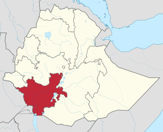
The Southern Nations, Nationalities, and Peoples' Region was a regional state in southwestern Ethiopia. It was formed from the merger of five kililoch, called Regions 7 to 11, following the regional council elections on 21 June 1992. Its government was based in Hawassa.

Hawassa known historically as Adare is a city in Ethiopia, on the shores of Lake Hawassa in the Great Rift Valley. It is 273 km (170 mi) south of Addis Ababa via Bishoftu, 130 km (81 mi) east of Sodo, and 75 km (47 mi) north of Dilla. The town serves as the capital of the Sidama Region. It lies on the Trans-African Highway 4 Cairo-Cape Town and has a latitude and longitude of 7°3′N38°28′E and an elevation of 1,708 meters (5,604 ft) above sea level. Its name comes from a Sidamic word meaning "wide body of water".

The Sidama Region is a regional state in southern Ethiopia. It was formed on 18 June 2020 from the Southern Nations, Nationalities, and Peoples' Region (SNNPR) and transformation of the Sidama Zone after a 98.52% vote in favour of increased autonomy in the 2019 Sidama referendum. It is the second smallest regional state in the country, after Harari. Sidama is the name of both the Sidama people and Sidama territory. Sidama is bordered to the south by the Oromia Region (except for a short stretch in the middle where it shares a border with Gedeo zone, in South Ethiopia Regional State, on the west by the Bilate River, which separates it from Wolayita Zone, and on the north and east by the Oromia Region. Towns in Sidama include Hawassa, the capital of Sidama and of SNNPR when it existed, Yirgalem, Wondogenet, Chuko, Hula, Bona, Bursa, Bensa, and Aleta Wendo. Sidama has a population of around 3.2 million in 2017 who speak the Cushitic language Sidama.

North Omo Zone was a zone in the Southern Nations, Nationalities, and Peoples' Region of Ethiopia. It was named after the Omo River, which flows in the western area of the former zone. In 2000 it was split into three zones: Dawro, Gamo Gofa, and Wolayita; and Basketo and Konta became special woredas.

Damot Weyde is a woreda in South Ethiopia Regional State of Ethiopia. It is a Part of the Wolayita Zone located in the Great Rift Valley, Damot Weyde is bordered on the south by Hobicha, on the west by Sodo Zuria, on the northwest by Damot Gale, on the north and northeast by Diguna Fango wordas. The administrative center of the woreda is Bedessa.
Kedida Gamela is a woreda in the Southern Nations, Nationalities, and Peoples' Region of Ethiopia. Part of the Kembata Tembaro Zone (KT), Kedida Gamela is bordered on the east and south by an exclave of the Hadiya Zone, on the west by Kacha Bira, on the northwest by Angacha, on the north by Damboya, and on the northeast by the Bilate River which separates it from Alaba. The northern part of Kedida Gamela was separated to create Damboya woreda.
Kacha Bira is a woreda in the Southern Nations, Nationalities, and Peoples' Region of Ethiopia. Part of the Kembata Tembaro Zone, Kacha Bira is bordered on the south by an exclave of the Hadiya Zone, on the southwest by the Wolayita Zone, on the west by Hadero Tunto, on the northwest by the Hadiya Zone, on the north by Doyogena and Angacha, and on the east by Kedida Gamela. Towns in Kacha Bira include Shinshicho and Hadero.
Shebedino is a woreda in Southern Nations, Nationalities, and Peoples' Region, Ethiopia. Part of the Sidama Zone located in the Great Rift Valley, Shebedino is bordered on the south by Dale, on the west by Boricha, on the north by Awasa Zuria, on the east by Gorche, and on the southeast by Wensho. Towns in Shebedino include Leku. Boricha and Gorche woredas were separated from Shebedino woreda.
Dale' is a woreda in Sidama Region, Ethiopia. Located in the Great Rift Valley, Dale is bordered on the south by Aleta Wendo and Chuko, on the west by Loko Abaya, on the northwest by Boricha, on the north by Shebedino, and on the east by Wensho. The major town in Dale is Irgalem, Irgalem. Parts of Dale woreda were separated to create Loko Abaya and Wensho woredas.
Hula is one of the woredas in the Southern Nations, Nationalities, and Peoples' Region of Ethiopia. Part of the Sidama Zone, Hula is bordered on the south by the Oromia Region, on the west by Dara, on the northwest by Aleta Wendo, on the north by Bursa, and on the east by Bona Zuria. The major town in Hula is Hagere Selam. Woredas of Bursa and Bona Zuria were separated from Hula.
Bensa is one of the woredas in a Sidama Region of Ethiopia.Daye is the capital city on soojjaata zoone that known as bensa zone occasionally. Bensa is one of popular woreda's in sidaama region.it extends into the Oromia Region like a peninsula, Bensa is bordered on the south and north by the Oromia Region, with Bona Zuria on the west, Arbegona on the northwest, Chere on the east, and Aroresa on the southeast. The major town in Bensa is Daye.
Sodo Zuria is one of the woredas in the South Ethiopia Regional State of Ethiopia. Part of the Wolayita Zone, Sodo Zuria is bordered on the southwest by Offa, on the west by Kindo Koysha, on the northwest by Damot Sore, on the north by Boloso Sore, on the northeast by Damot Gale, on the east by Damot Weyde, on the west by Bayra Koysha and on the southeast by Humbo. Sodo city is an administrative center for Sodo Zuria woreda.
Humbo is one of the woredas in the South Ethiopia Regional State of Ethiopia. It is a Part of the Wolayita Zone located in the Great Rift Valley, Humbo is bordered on the southeast by Abala Abaya, on the south by the Gamo Zone, on the west by Offa, on the north by Sodo Zuria and Bayra Koysha. The administrative center of Humbo is Tebela.
Arba Minch Zuria is a woreda in Southern Nations, Nationalities, and Peoples' Region, Ethiopia. A part of the Gamo Zone located in the Great Rift Valley, Arba Minch Zuria is bordered on the south by the Dirashe special woreda, on the west by Bonke, on the north by Dita and Chencha, on the northeast by Mirab Abaya, on the east by the Oromia Region, and on the southeast by the Amaro special woreda. This woreda also includes portions of two lakes and their islands, Abaya found in Lante kebele and Chamo found in all Ganta Kanchama Ochole and Zeyise kebeles. Nechisar National Park is located between these lakes. City of Arba Minch is surrounded by Arba Minch Zuria.
Seraro is one of the woredas in the Oromia Region of Ethiopia. Part of the West Arsi Zone located in the Great Rift Valley, Seraro is bordered on the south and west by the Southern Nations, Nationalities and Peoples' Region, on the north by Shala, and on the east by Naannawa Shashamane; its western boundary is defined by the course of the Bilate River. The administrative center of this woreda is Loke.
Naannawa Shashamane is a woreda in Oromia Region, Ethiopia. It is named after the town of Shashamene what was separated from this woreda. Part of the West Arsi Zone located in the Great Rift Valley, Shashamene is bordered on the south by the Southern Nations, Nationalities and Peoples Region, on the west by Shala, on the north by Arsi Negele, on the east by the Kore, and on the southeast by Kofele. The largest town in Shashamene is Kuyera.
Boricha is one of the woredas in the Southern Nations, Nationalities, and Peoples' Region of Ethiopia. Part of the Sidama Zone located in the Great Rift Valley, Boricha is bordered on the south by Loko Abaya, on the west by the Wolayita Zone, on the northwest by the Oromia Region, on the northeast by Awasa Zuria, on the east by Shebedino, and on the southeast by Dale. Boricha was separated from Shebedino woreda.
Malga is one of the woredas in the Southern Nations, Nationalities, and Peoples' Region (SNNPR) of Ethiopia. Part of the Sidama Zone located in the Great Rift Valley, Malga is bordered on the south by Gorche on the southwest by Shebedino, on the west by Awasa Zuria, on the north by Wondo Genet, and on the east by the Oromia Region. Malga was separated from Awasa woreda.
Wondo Genet is a woreda in Southern Nations, Nationalities, and Peoples' Region, Ethiopia. Part of the Sidama Zone located in the Great Rift Valley, Wondo Genet is bordered on the south by Malga, on the west by Awasa Zuria, and on the north and east by the Oromia Region. The administrative center is Wondo Genet. Wondo Genet was part of former Awasa woreda.
Dila Zuria is one of the woredas in the Southern Nations, Nationalities and Peoples' Region of Ethiopia. Part of the Gedeo Zone, Dila Zuria is bordered on the southwest by Wenago, on the west by the Oromia Region, on the north by the Sidama Zone, and on the southeast by Bule. Dila town is surrounded by Dila Zuria. Dila Zuria was part of Wenago woreda.


