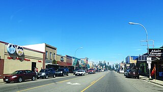
Walker is a city in Cass County, Minnesota, United States. The population was 966 at the 2020 census. It is the county seat of Cass County.

Charlevoix Municipal Airport is a city-owned, public-use airport located one nautical mile (2 km) southwest of the central business district of Charlevoix, a city in Charlevoix County, Michigan, United States. It is mostly used for general aviation, but also offers passenger service to Beaver Island via Island Airways and Fresh Air Aviation.
Hutchinson Municipal Airport, also known as Butler Field, is a public airport located two miles (3 km) south of the central business district of Hutchinson, a city in McLeod County, Minnesota, United States. It is owned by the City of Hutchinson. The airport is home to the Civil Air Patrol. The FBO is operated by ASI JET.
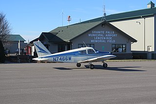
Granite Falls Municipal Airport, also known as Lenzen-Roe Memorial Field, is a public-use airport in Yellow Medicine County, Minnesota, United States. It is owned by the City of Granite Falls and located four nautical miles (7 km) south of its central business district. The airport is situated near State Highway 23.
Longville Municipal Airport is a city-owned public-use airport located one nautical mile (1.85 km) northeast of the central business district of Longville, a city in Cass County, Minnesota, United States.

Dalhart Municipal Airport is in unincorporated Hartley County, Texas, three miles (5 km) southwest of Dalhart, Texas, a city straddling the border of Dallam and Hartley counties in the northwest corner of the Texas Panhandle.

Grand Marais/Cook County Airport is a county-owned public-use airport located eight miles (13 km) northwest of the central business district of Grand Marais, a city in Cook County, Minnesota, United States. This airport replaced the former Devil's Track Municipal Airport located on the shore of Devil's Track Lake, one mile (1.6 km) south of the current airport.
Tower Municipal Airport is a city-owned public-use airport located one nautical mile (2 km) northwest of the central business district of Tower, a city in Saint Louis County, Minnesota, United States. It is located on Lake Vermilion and is also known as Tower Municipal Airport & Seaplane Base.
Albert Lea Municipal Airport is three miles (6 km) north of Albert Lea, in Freeborn County, Minnesota, United States.

Red Wing Regional Airport is a city-owned public-use airport located in Pierce County, Wisconsin, three nautical miles (6 km) northeast of the central business district of Red Wing, a city in Goodhue County, Minnesota, United States.
Litchfield Municipal Airport is a city-owned public-use airport located two nautical miles southeast of the central business district of Litchfield, a city in Meeker County, Minnesota, United States. The airport at this location opened in 1987. The original Litchfield Airport was closer to town and was located near the County Fair Grounds.
Moorhead Municipal Airport is a city-owned public-use airport located in Moorhead, a city in Clay County, Minnesota. It has one runway and, as of 2010, it served general aviation only.
Indy South Greenwood Airport is a city-owned public-use airport in Greenwood, a city in Johnson County, Indiana, United States. It is 10 miles (16 km) southeast of Downtown Indianapolis. The airport was founded in September 1947 and is primarily used for general aviation. The airport has several on-field businesses, including a flight school and maintenance shop. In 2022 the airport was awarded Airport of the Year by Aviation Indiana.
Blue Earth is a city-owned public-use airport located three miles south of the city of Blue Earth, Minnesota in Faribault County.
Paynesville Municipal Airport is a city-owned public-use airport located one mile southwest of the city of Paynesville, Minnesota in Stearns County.
Glencoe Municipal Airport also known as Vernon Perschau Field is a city-owned public-use airport located three miles south-east of the city of Glencoe, Minnesota in McLeod County.

Rushford Municipal Airport also known as Robert W. Bunke Field is a city-owned public-use airport located three miles west of the city of Rushford, Minnesota in Fillmore County.
Windom Municipal Airport is a city-owned public-use airport located three miles north of the city of Windom, Minnesota in Cottonwood County.
Redwood Falls Municipal Airport is a city-owned public-use airport located two miles north-east of the city of Redwood Falls, Minnesota in Redwood County.
Hallock Municipal Airport is a city-owned public-use airport located one mile south of the city of Hallock, Minnesota in Kittson County.


