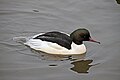
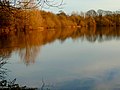
Hay-a-Park Gravel Pit is a Site of Special Scientific Interest, or SSSI, adjacent to the east side of the town of Knaresborough, North Yorkshire, England. Having been a disused and flooded quarry since the 1970s, it now consists of the large Hay-a-Park Lake and three smaller ponds, besides associated reedbeds, scrub, woodland and grassland. It was designated as a SSSI in 1995 because it supports a number of wintering birds, including a large flock of goosander. This site is "one of the most northerly inland breeding populations of reed warbler in Britain."[1] Hay-a-Park was once part of a royal park, an early landowner being Edward II.
The area once belonged to the Crown; then Edward II gave it to his favourite, Piers Gaveston. After Gaveston was executed, it passed back to the Crown, but was subject to poaching for some time.[2] In the 14th century the area was known as Park de la Haye where Edward III bred horses.[3] Edward's fifteen-year-old wife Philippa of Hainault was given this land on the occasion of her marriage; she was later the mother of the Black Prince (whose statue stands in Leeds City Square) and John of Gaunt.[4][nb 1] Another story says that in the 11th or 12th century Henry I conferred the lands to Gamel de Scriven, and they remained in the family under various names including Edward II until the last heir, Sir Charles Slingsby, died falling from his horse into the river in 1869, leaving no issue.[5][6]
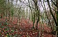
Tree-lined lakeside footpath
The area later became known as Haya Park. By the seventeenth century the land was at least partly wooded, and managed for timber. By the end of that century it was owned by Lady Hewley, who used its rents to support the Church and charities.[2] When its farmland was valued in 1755 by Robert Moody of York, the land was considered potentially good for cultivation, but contemporary farmers were "poor idle drunken ignorant fellows" who spent Sundays in the alehouse; so that the land was "miserably run and full of weeds," with no prospect of land improvement.[7] In the 19th century the leasehold of Haya Park was purchased for the purpose of rectorialtithes by York Minster;[8] it was still a royal park, where deer were protected.[2]
Part of Hay-a-Park later became a gravel works, and the site occupies a section which has been "largely undisturbed since the completion of extraction in the early 1970s."[1]
Site location and designation
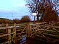
Unlabelled entrance to Hay-a-Park Gravel Pit
Hay-a-Park Gravel Pit is a 44.8687 hectares (0.4487km2; 0.1732sqmi) biological Site of Special Scientific Interest (SSSI),[9] consisting of "standing open water and canals."[10] This reserve has no parking area, no visitor facilities, and no official public footpaths. Fishing and swimming are not permitted, and dog-walking is discouraged due to disturbance of water birds. The site is adjacent to the eastern edge of Knaresborough, accessible by public footpath from two unlabelled entrances on Park Lane, one located near the railway bridge, and the other next to Knaresborough Rugby Club.[11]
Although the former quarry pit Hay-a-Park Lake may be deep, Natural England recommends that the presence of any shallow water areas be maintained. This is for the benefit of wintering waders and feeding ducks and geese. Shallow waters allow aquatic plants to receive light, thereby allowing breeding conditions for dragonflies and damselflies. "Protection of appropriate water quality" is required, as is regulation of potential incoming water and sediment. "Bottom feeding coarse fish" must be removed, because they may "uproot plants and disturb sediments." "Appropriate nesting and feeding conditions are maintained" with regard to open land, scrub and reeded areas. "Recreational activities should be managed sympathetically to avoid conflict with the management of the waterbody for nature conservation," and "recreational use of woodland should be discouraged" should the site contain a heronry.[23]
Development and risk assessment
A 2012 assessment of the site was "unfavourable, declining." Notices have been erected at two entrance points of the site, to remind the public that there has been a continuing concern about "illegal fishing" here. There are also issues of freshwater fish-stocking, public access and disturbance.[24][25] A woman was photographed swimming recreationally in the lake in winter 2019, putting greylags to flight.[nb 2] Some visitors to Hay-a-Park have been carrying out three categories of "operations likely to damage the special interest," namely articles 16a, 27 and 28 of Natural England's views about management of the SSSI.[26] Nevertheless, the published audit for the Knaresborough Development Plan of 2016 described the site as being available for recreational use, and designated it as an "important community area" (ICA).[27]
Gate with no-fishing sign
A recreational swimmer strikes out for the centre of the lake, disturbing wintering birds
This page is based on this Wikipedia article Text is available under the CC BY-SA 4.0 license; additional terms may apply. Images, videos and audio are available under their respective licenses.