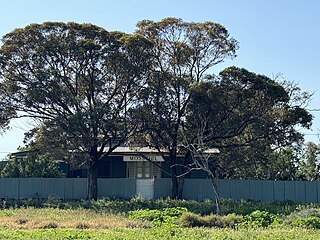
Hay War Memorial High School (abbreviated as HWMHS) is a publicco-educationalsecondaryday school, located on Pine Street in central Hay, a town located in the western Riverina region of New South Wales, Australia. The school is operated by the NSW Department of Education with students from Year 7 to Year 12. The school was originally established on 1 January 1918 at the Hay Public School campus, but moved to a separate purpose-built site on Anzac Day, 25 April 1923, half paid for by public subscription from the citizens of Hay, as the town's war memorial to the service of Hay and district citizens in the First World War.[1]
The provision of secondary education in the town of Hay was limited prior to the establishment of the high school. In 1908, the Hay Public School (established in 1869) was upgraded in status to a District School, which provided both primary and secondary education in the same school.[2] In early 1917, the citizens of the town lobbied the NSW Government for the establishment of a separate high school, and a deputation led by the local state member of parliament for Murray, Robert Scobie, met with the Minister of Public Instruction, Augustus James, who committed to investigate the establishment of a high school in the town.[3][4] The establishment of a public high school in Hay was formally announced in the Government Gazette on 8 October 1917.[5] On 1 January 1918, the Hay High School was established in a section of the existing buildings at Hay District School (which was downgraded to a primary school) on Lachlan Street, with an initial enrolment of 38 boys and 31 girls.[6][7][8]
With the new school attracting students from as far afield as Broken Hill, the need for student hostel accommodation became acute.[9] In August 1918, the government acquired "Lansdowne" house in Moppett Street to establish the first student hostel.[10][11] As the student population grew, additional hostels opened in the town, growing to five by 1935: Claughton House (Presbyterian, opened 1925), Butterworth (Methodist girls, opened 1921), Riverina House Hostel (Anglican girls, opened 1930), the Government Hostel (Lansdowne, opened 1918), and the Linton House hostel (Anglican boys, 1935–1946).[12][13][14][15][16][17][18]
In the years following the end of the First World War, the town of Hay sought ideas for commemorating the service of Hay citizens in the war. At a meeting held on 19 September 1919, a formal committee investigating proposals agreed upon the construction of a purpose-built memorial high school, with an estimated cost of between £6,000 and £8,000 and a commitment from the Department of Education to meet half the cost, if the town was able to raise the remaining half.[19] With the establishment of the Hay War Memorial Fund to collect public donations for the project in early 1920,[20]The Riverine Grazier opined:
It may fairly be asked what has induced Hay to decide upon a War Memorial High School. The answer is that such an institution has a measure of permanency about it that many other methods cannot claim; that it tends to make Hay the educational centre of Riverina; and that it will be a constant reminder to the growing children of Hay of the splendid part their forefathers played in the greatest of all wars. In our opinion, these are worthy objects of a war memorial; they are objects which make no levy on future generations for cost, of maintenance; and they perpetuate, in the most effective manner, the memories of those who gave their lives, or who jeopardised their lives, in the cause of freedom.[21]
On 2 August 1920, the Hay Municipal Council voted unanimously to set aside a 27-acre (11ha) site in central Hay for the school.[22]
The completed Hay War Memorial High School was finally opened on 25 April 1923, Anzac Day, by the Minister for Education, Albert Bruntnell, with the final cost coming to £15,980.[29] The completed building included trachyte slabs as rolls of honour for the war memorial, installed on the façade.[30] The architectural journal, Building, noted that the school was "of exceptionally fine design in its architectural features. The brickwork used to fine advantage, and the entrance porch is a pretentious affair with broad steps and finely grouped columns."[31] On 20 May 1926, the school was visited by the Governor-General of Australia, Lord Stonehaven, who declared that it was the "finest war memorial in the British Empire".[32][33]
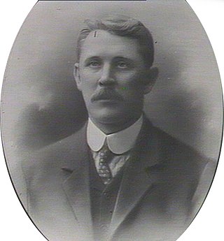
The first headmaster of the school was Leslie Ethelbert Penman, BA, who served from 1918 until 1925, when he was appointed to be headmaster of Goulburn High School.[34][35][36] The second headmaster was R. C. Taylor, BA BEc, from 1925 to 1928.[37][38] The third headmaster was James H. Killip, BA, from 1928 to 1931.[39][40] The fourth headmaster was Hector Walker, MA, from 1931 to 1933.[41] The fifth headmaster from 1933 to 1937 was Arthur Andrew Beckett, BA BEc.[42]
More recent additions to the school such as the library and art, technics and music building were built in 1973, and additional classrooms were built in 1984.[43] On 3 July 2007, the science and library block was severely damaged by a gas explosion.[44] A 14-year-old boy was later arrested and charged for the crime.[45] The original main building of the school, and associated landscaping, movable items, and war memorials, are listed as a heritage item in the NSW Department of Education Section 170 Heritage Register.[46]
The Willandra National Park is a protected national park that is located in the Far West region of New South Wales, in eastern Australia. The 19,386-hectare (47,900-acre) national park is situated approximately 580 kilometres (360 mi) west of Sydney and comprises flat grassy plain bounded to the north by Willandra Creek, which is a tributary of the Lachlan River.
Hay is a town in the western Riverina region of south western New South Wales, Australia. It is the administrative centre of Hay Shire local government area and the centre of a prosperous and productive agricultural district on the wide Hay Plains.
Mount Hope is a settlement in western New South Wales, Australia. It is situated on the Kidman Way, 95 kilometres north of Hillston and 160 km south of Cobar. During the 1870s, a copper mine commenced operations at Mount Hope. In the mid-1880s, a proposed township in the area was officially surveyed and named Nombinnie, but the name has seldom been used. In the meantime, the town of Mount Hope sprang up, closer to the mine.
Goolgowi is a small town located in western New South Wales, Australia, around 650 kilometres (400 mi) west of Sydney via the Mid-Western Highway and is the administrative centre of Carrathool Shire. At the 2016 census, Goolgowi had a population of 402.
Gunbar is in the Riverina district of south-western New South Wales in Australia, on a wide bend of the Mid-Western Highway between Goolgowi and Hay. It is part of the Carrathool Shire local government area, administered from Goolgowi. At the 2006 census, Gunbar had a population of 97 people.
Mathoura is a small town in the Riverina region of southern New South Wales, Australia, in the Murray River Council local government area. At the 2016 census, Mathoura had a population of 938. At the 2021 census the population was 1,002.
Rankins Springs is a village in the Riverina region of New South Wales, Australia in Carrathool Shire and on the Mid-Western Highway. At the 2011 census, Rankins Springs had a population of 299 residents living in 145 private dwellings. This dropped to 174 in 2016, but rebounded to 208 in 2021. The settlement is strung out along the Mid-Western Highway and adjacent railway line. The main agricultural activities of the district around Rankins Springs are the growing of crops such as wheat and oats, and beef-cattle.
Mossgiel is a location in New South Wales, Australia, in Carrathool Shire. It was a township on the coach route between the Lachlan and Darling Rivers, 50 km southeast of Ivanhoe near the junction with the road to Hillston. The settlement experienced a steady decline during the 20th century. Nowadays Mossgiel township consists of one house and a community hall.
Maitland High School is a government-funded co-educational comprehensive secondary day school, located on High Street, East Maitland, New South Wales, Australia.
Hay and Hell and Booligal is an 1896 poem by the Australian bush poet A. B. 'Banjo' Paterson who wrote the poem while working as a solicitor with the firm of Street & Paterson in Sydney. It was first published in The Bulletin on 25 April 1896. The poem was later included in Paterson's collection Rio Grande's Last Race and Other Verses, first published in 1902.
Griffith High School was a government-funded co-educational comprehensive secondary day school, located in Griffith, in the Riverina region of New South Wales, Australia.
J J Cahill Memorial High School is a public co-educational secondary day school, located on Sutherland Street in Mascot, an inner southern suburb of Sydney, New South Wales, Australia. The school is operated by the NSW Department of Education with students from Year 7 to Year 12. Established in 1961 as a comprehensive high school, the school was named in honour of John Joseph Cahill, the local member of parliament and the Premier of New South Wales from 1952 to his death in 1959. The school is one of four NSW state schools with "memorial" in its name, alongside Sir Henry Parkes Memorial Public School in Tenterfield, Hay War Memorial High School, and Farrer Memorial Agricultural High School in Tamworth.
James Ashton was an Australian politician.
The Western Grazier was a newspaper published from 1880 until 1951, covering the central Darling River region of New South Wales. It was published in Wilcannia until 1940, when it moved to Broken Hill.
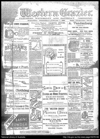
The Riverine Grazier is an English language newspaper published in Hay, New South Wales from 1873. The paper absorbed the Riverina Times, Hay Standard and Journal of Water Conservation in October 1902.
John Beveridge, JP was a New South Wales businessman, sportsman and local government politician, who served as an Alderman (1886–1891) and Mayor of Redfern (1891).
Elsinora Station, most commonly known as Elsinora, is a pastoral lease that has operated as both a sheep station and a cattle station in outback New South Wales. It is situated approximately 160 kilometres (99 mi) north of White Cliffs and 240 kilometres (149 mi) north west of Bourke close to the Queensland border.
Crows Nest Boys High School is a former high school located at 365 Pacific Highway in the Sydney suburb of Crows Nest, New South Wales, Australia. It was a boys' high school operated by the New South Wales Department of Education with students from years 7 to 12. The school was first established in 1883 as St Leonards North Public School. However, the school was declared surplus to the needs of the department and officially closed in 1992. The school and its heritage-listed buildings are now the campus of North Sydney Girls High School.
The Hay Bridge is a road bridge that carries the Cobb Highway across the Murrumbidgee River at Hay, New South Wales, Australia. The current bridge is the second bridge located in Hay that crosses the Murrumbidgee; the first bridge was in operation from 1873 until 1973; the second and current bridge has operated since 1973.
Coonabarabran High School is a public co-educational secondary day school, located on the Newell Highway in southern Coonabarabran, a town located in the Central West and North West Slopes regions of New South Wales, Australia. The school is operated by the NSW Department of Education with students from Year 7 to Year 12. The school was originally established in January 1942 as the Coonabarabran Intermediate High School, providing primary and secondary education, and later reconstituted in 1962 as a comprehensive high school.
↑ Welsh, Alex C. (15 June 1923). "The Hay War Memorial High School. The Building Described". Education: Journal of the N.S.W. Public School Teachers Federation. 4 (8). National Library of Australia (Trove): 18–20. Retrieved 24 October 2023.
↑ "EDUCATIONAL FACILITIES". The Riverine Grazier. Hay, New South Wales, Australia. 6 November 1917. p.2. Retrieved 25 October 2023– via National Library of Australia.
↑ "THE HAY HIGH SCHOOL". The Riverine Grazier. Hay, New South Wales, Australia. 15 February 1918. p.2. Retrieved 25 October 2023– via National Library of Australia.
↑ "HAY HIGH SCHOOL". The Riverine Grazier. Hay, New South Wales, Australia. 15 March 1918. p.2. Retrieved 25 October 2023– via National Library of Australia.
↑ "A MUNIFICENT GIFT". The Sydney Morning Herald. Sydney, New South Wales, Australia. 1 December 1923. p.18. Retrieved 25 October 2023– via National Library of Australia.
↑ "PRESBYTERIAN BOYS' HOSTEL AT HAY". The Riverine Grazier. Hay, New South Wales, Australia. 3 February 1925. p.2. Retrieved 25 October 2023– via National Library of Australia.
↑ "HAY WAR MEMORIAL HIGH SCHOOL". The Riverine Grazier. Hay, New South Wales, Australia. 23 May 1930. p.4. Retrieved 25 October 2023– via National Library of Australia.
↑ "CHURCH OF ENGLAND GIRLS' HOSTEL". The Riverine Grazier. Hay, New South Wales, Australia. 24 December 1929. p.2. Retrieved 25 October 2023– via National Library of Australia.
↑ "THE HAY WAR MEMORIAL". The Riverine Grazier. Hay, New South Wales, Australia. 30 July 1920. p.2. Retrieved 24 October 2023– via National Library of Australia.
↑ "THE HAY WAR MEMORIAL". The Riverine Grazier. Hay, New South Wales, Australia. 3 August 1920. p.2. Retrieved 24 October 2023– via National Library of Australia.
↑ "HAY HIGH SCHOOL". Sunraysia Daily. Mildura, Victoria, Australia. 24 December 1921. p.5. Retrieved 24 October 2023– via National Library of Australia.
↑ "TENDERS FOR WORKS IN CONNECTION WITH PUBLIC SCHOOLS". Government Gazette Of The State Of New South Wales. No.122. New South Wales, Australia. 19 August 1921. p.4855. Retrieved 24 October 2023– via National Library of Australia.
↑ "HIGH SCHOOL". The Sydney Morning Herald. Sydney, New South Wales, Australia. 10 March 1922. p.8. Retrieved 24 October 2023– via National Library of Australia.
↑ "THE HAY WAR MEMORIAL HIGH SCHOOL". The Riverine Grazier. Hay, New South Wales, Australia. 10 March 1922. p.2. Retrieved 24 October 2023– via National Library of Australia.
↑ "HAY'S WAR MEMORIAL". The Riverine Grazier. Hay, New South Wales, Australia. 10 March 1922. p.2. Retrieved 24 October 2023– via National Library of Australia.
↑ "THE HAY WAR MEMORIAL HIGH SCHOOL". The Riverine Grazier. Hay, New South Wales, Australia. 24 April 1923. p.2. Retrieved 24 October 2023– via National Library of Australia.
↑ "Hay War Memorial High School". Building. 30 (178). National Library of Australia (Trove): 99. 12 June 1922. Retrieved 24 October 2023.
↑ "GOVERNOR GENERAL AT HAY". The Riverine Grazier. Hay, New South Wales, Australia. 21 May 1926. p.2. Retrieved 25 October 2023– via National Library of Australia.
↑ "RETIREMENT OF MR. L. E. PENMAN". The Riverine Grazier. Hay, New South Wales, Australia. 3 August 1945. p.2. Retrieved 24 October 2023– via National Library of Australia.
↑ "HAY WAR MEMORIAL HIGH SCHOOL". The Riverine Grazier. Hay, New South Wales, Australia. 17 July 1928. p.2. Retrieved 24 October 2023– via National Library of Australia.
↑ "The Departure of Mr. R.C. Taylor". The Riverine Grazier. Hay, New South Wales, Australia. 31 August 1928. p.2. Retrieved 24 October 2023– via National Library of Australia.
↑ "NEWS ITEMS". The Hillston Spectator And Lachlan River Advertiser. Hillston, New South Wales, Australia. 30 August 1928. p.1. Retrieved 24 October 2023– via National Library of Australia.
↑ "DEPARTURE OF MR J.H. KILLIP". The Riverine Grazier. Hay, New South Wales, Australia. 10 February 1931. p.2. Retrieved 24 October 2023– via National Library of Australia.
↑ "HAY WAR MEMORIAL HIGH SCHOOL". The Riverine Grazier. Hay, New South Wales, Australia. 22 December 1933. p.4. Retrieved 24 October 2023– via National Library of Australia.
↑ "HAY WAR MEMORIAL HIGH SCHOOL". The Riverine Grazier. Hay, New South Wales, Australia. 21 December 1937. p.1. Retrieved 24 October 2023– via National Library of Australia.
This page is based on this Wikipedia article Text is available under the CC BY-SA 4.0 license; additional terms may apply. Images, videos and audio are available under their respective licenses.