
Springfield is a town in Otsego County, New York, United States. The population was 1,358 at the 2010 census.

The Mohawk River is a 149-mile-long (240 km) river in the U.S. state of New York. It is the largest tributary of the Hudson River. The Mohawk flows into the Hudson in Cohoes, New York, a few miles north of the city of Albany. The river is named for the Mohawk Nation of the Iroquois Confederacy. It is a major waterway in north-central New York. The largest tributary, the Schoharie Creek, accounts for over one quarter (26.83%) of the Mohawk River's watershed. Another main tributary is the West Canada Creek, which makes up for 16.33% of the Mohawk's watershed.

The Kalamazoo River is a river in the U.S. state of Michigan. The river is 130 miles (210 km) long from the junction of its North and South branches to its mouth at Lake Michigan, with a total length extending to 178 miles (286 km) when one includes the South Branch. The river's watershed drains an area of approximately 2,020 square miles (5,200 km2) and drains portions of eight counties in southwest Michigan: Allegan, Barry, Eaton, Van Buren, Kalamazoo, Calhoun, Jackson, Hillsdale, Kent and Ottawa. The river has a median flow of 1,863 cubic feet per second (52.8 m3/s) at New Richmond, upstream from its mouth at Saugatuck.

The Sacandaga River is a 64-mile-long (103 km) river in the northern part of New York in the United States. Its name comes from the Native American Sa-chen-da'-ga, meaning "overflowed lands".
Assunpink Creek is a 22.9-mile-long (36.9 km) tributary of the Delaware River in western New Jersey in the United States. The name Assunpink is from the Lenape Ahsën'pink, meaning "stony, watery place".

Otego Creek is a 32.7-mile-long (52.6 km) tributary of the Susquehanna River in Otsego County, New York. Otego Creek rises in the Town of Otsego and flows south through the Towns of Hartwick and Laurens, before joining the Susquehanna River southwest of the City of Oneonta.

Oaks Creek is a river that drains Canadarago Lake, which is situated in the north central region of Otsego County, New York. The creek begins by the Hamlet of Schuyler Lake and flows southeast approximately 9.32 miles (15.00 km), dropping only 105 feet (32 m) in elevation, before converging with the Susquehanna River south of the Village of Cooperstown, by the Hamlet of Index. From the source to Oaksville the creek flows along Panther Mountain. Fly Creek is a main tributary, that converges with Oaks Creek south of the Hamlet of Fly Creek.
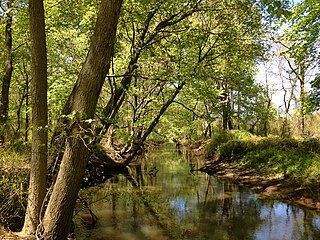
Cripple Creek is a river in southern Herkimer County and northern Otsego County in the state of New York. It begins northeast of Warren and flows through Weaver Lake then Young Lake before flowing into Otsego Lake south of Springfield Center. Was formally referred to as Lawyers Creek.
Mink Creek or Otskonoga, also known as Trout Brook, is a stream in northern Otsego County, New York. Its source is adjacent to US Route 20 just east of the community of Brighton and west-northwest of the Village of Richfield Springs and flows northeast into an unnamed swamp in adjacent Herkimer County. It then exits the swamp and flows south back into Otsego County before converging with Canadarago Lake south of Richfield Springs. The Iroquois' name for the creek is Otskonoga.
Ocquionis Creek, also known as Fish Creek, is a river in southern Herkimer County and northern Otsego County in the State of New York. It begins northeast of the Hamlet of Jordanville and flows generally southward before flowing into the northern end of Canadarago Lake south of the Village of Richfield Springs. Ocquionis is an Iroquois word that translates to "he is a bear".
Hyder Creek is a river in Otsego County in the state of New York. It begins west of the Hamlet of Richfield and flows east, then southeast before flowing into Canadarago Lake south of the Village of Richfield Springs.
Herkimer Creek is a river in Otsego County in the state of New York. It begins west-southwest of the Hamlet of Richfield and northwest of the Hamlet of Dogtown and begins flowing mostly southeast before flowing into Canadarago Lake northeast of the Hamlet of Schuyler Lake.

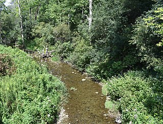
Shadow Brook, also known as East Springfield Brook, is a river in northern Otsego County in the U.S. State of New York. It begins north-northeast of the Hamlet of East Springfield, and flows into Otsego Lake south-southeast of the Hamlet of Springfield Center, near Glimmerglass State Park. It is the largest watershed in the Otsego Lake basin.

The Canajoharie Creek is a river that flows into the Mohawk River in the Village of Canajoharie in the U.S. State of New York. The name "Canajoharie" is a Mohawk language term meaning "the pot that washes itself", referring to the "Canajoharie Boiling Pot", a 20-foot (6.1 m) wide and 10-foot (3.0 m) deep pothole in the Canajoharie Creek, just south of the village of Canajoharie. Bowmans Creek is one main tributary that enters the creek east of the Hamlet of Sprout Brook. The other main tributary is Brimstone Creek which enters the creek north-northwest of the Village of Ames.
Crum Creek, also known as Cathatachua Creek, is a river in Herkimer County in the state of New York. It begins north of Little Falls and flows in a generally southeast direction before flowing into the Mohawk River in the hamlet of East Creek.
Caroga Creek is a river in Fulton and Montgomery counties in the U.S. State of New York. It begins at East Caroga Lake and flows south passing through Rockwood Lake before converging with the Mohawk River in the Hamlet of Palatine Church.
Cayadutta Creek is a river in Fulton and Montgomery counties in the state of New York. It begins northwest of Gloversville and flows in a general southward direction before flowing into the Mohawk River in Fonda. The Indian meaning of Cayadutta is "rippling waters" or "shallow water running over stones". This stream has commercial and historical importance as the cities of Johnstown and Gloversville lie on its banks.
Roods Creek is a river in Delaware County, New York. It begins just south of Cannonsville Reservoir and flows south into Crystal Lake. After exiting Crystal Lake it continues flowing south and then flows into Silver Lake. After exiting Silver Lake it continues southward before converging with the West Branch Delaware River east of the hamlet of Hale Eddy.

Summit Lake is a small lake in Otsego County, New York. It is located northeast of Springfield Center. Summit Lake is unique, as it drains south via Hayden Creek which flows into Otsego Lake as well as north toward the Mohawk River. Fish species present in the lake include largemouth bass, chain pickerel, brown bullhead and yellow perch.

Bowmans Creek is a river in Montgomery County, New York. It begins west of the hamlet of Hessville and just south of the hamlet of Ripple Corners. It then flows in a mostly southeast direction for a few miles passing through the hamlet of Sprout Brook before flowing into the Canajoharie Creek just east of the hamlet of Sprout Brook.


