
The Royal Society Range is a mountain range in Victoria Land, Antarctica. With its summit at 4,025 metres (13,205 ft), the massive Mount Lister forms the highest point in this range. Mount Lister is located along the western shore of McMurdo Sound between the Koettlitz, Skelton and Ferrar glaciers. Other notable local terrain features include Allison Glacier, which descends from the west slopes of the Royal Society Range into Skelton Glacier.
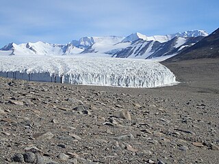
Koettlitz Glacier is a large Antarctic glacier lying west of Mount Morning and Mount Discovery in the Royal Society Range, flowing from the vicinity of Mount Cocks northeastward between Brown Peninsula and the mainland into the ice shelf of McMurdo Sound.
The Alph River is a small river in Antarctica, running into Walcott Bay, Victoria Land. It is in an ice-free region at the west of the Koettlitz Glacier, Scott Coast. The Alph emerges from Trough Lake and flows through Walcott Lake, Howchin Lake, and Alph Lake. It ends in a subglacial flow beneath Koettlitz Glacier to McMurdo Sound.
Foster Glacier is a glacier in the Royal Society Range, Antarctica, 4 nautical miles (7 km) south of Mount Kempe, flowing southeast into the Koettlitz Glacier. It was named by the Advisory Committee on Antarctic Names in 1963 for Major James Foster, United States Marine Corps, assistant air operations officer for U.S. Navy Task Force 43 in Antarctica, 1960.

Arrowsmith Peninsula is a cape about 40 miles (64 km) long on the west coast of Graham Land, west of Forel Glacier, Sharp Glacier and Lallemand Fjord, and northwest of Bourgeois Fjord, with Hanusse Bay lying to the northwest. It was surveyed by the Falkland Islands Dependencies Survey (FIDS) in 1955-58 and named for Edwin Porter Arrowsmith, Governor of the Falkland Islands.
Garwood Glacier is a glacier occupying the northwest part of Garwood Valley, in Victoria Land, Antarctica. It was first mapped by the British National Antarctic Expedition (1901–04), but was not named until 1911, when Thomas Griffith Taylor of the British Antarctic Expedition, 1910–13, named it for Edmund J. Garwood, professor of geology and mineralogy at the University of London.
Adams Glacier is a small glacier immediately south of Miers Glacier in Victoria Land. The heads of Adams and Miers glaciers, both located in the Miers Valley, are separated by a low ridge, and the east end of this ridge is almost completely surrounded by the snouts of the two glaciers, which nearly meet in the bottom of the valley, about 1 mile (1.6 km) above Lake Miers, into which they drain. It was named by the New Zealand Northern Survey Party of the Commonwealth Trans-Antarctic Expedition (1956–58) after Lieutenant Jameson Adams, second in command of the shore party of the British Antarctic Expedition (1907–09), who was one of the men to accompany Ernest Shackleton to within 97 miles (156 km) of the South Pole.
Armitage Saddle is the saddle at the head of Blue Glacier, overlooking the Howchin and Walcott Glaciers which drain toward Walcott Bay in the Koettlitz Glacier. The saddle is at the south end of the "Snow Valley" that was mapped by Armitage in 1902, and subsequently wrongly omitted from maps of the British Antarctic Expedition, 1910–13. The New Zealand Blue Glacier Party of the Commonwealth Trans-Antarctic Expedition, 1956–58, established a survey station on the saddle in September 1957. They named it for Lieutenant Albert Armitage, second-in-command of the British National Antarctic Expedition, 1901–04, in recognition of his exploration in this area.
Walcott Bay is a bay indenting the coast of Victoria Land between Walcott Glacier and Heald Island. It was named by the British Antarctic Expedition (1910–13) in association with Walcott Glacier.
Kukri Hills is a prominent east-west trending range, about 25 nautical miles (46 km) long and over 2,000 metres (6,600 ft) high, forming the divide between Ferrar Glacier on the south and Taylor Glacier and Taylor Valley on the north, in Victoria Land, Antarctica.
Koettlitz Névé is a roughly circular névé about 7 nautical miles (13 km) wide at the head of Koettlitz Glacier, Victoria Land, Antarctica. The névé is bounded to the west and south by Mount Talmadge, Mount Rees and Mount Cocks, and to the east by Mount Morning. It was named by the Advisory Committee on Antarctic Names in 1994 in association with Koettlitz Glacier.
Discovery Glacier is a broad glacier, 9 nautical miles (17 km) long, between Hurricane Ridge and Mount Discovery on the Scott Coast, Victoria Land. The glacier flows north to coalesce with the eastern margin of lower Koettlitz Glacier. It was named by the Advisory Committee on Antarctic Names (1999) in association with Mount Discovery, which Captain Robert Falcon Scott had named after the expedition ship of the British National Antarctic Expedition, 1901–04.
The Pyramid is a small but distinctive peak of Omak just south of Pyramid Trough, at the west side of the Koettlitz Glacier. The descriptive name appears to have been first used by the British Antarctic Expedition of 1910–1913.
Glimpse Glacier is an alpine glacier composed of two segments, separated by an icefall, which flow northeast from the névé in the area between Mount Kempe and Mount Huggins, Antarctica. It joins Pipecleaner Glacier 2 nautical miles (4 km) south of the confluence of the latter with Radian Glacier. It was so named by the Victoria University of Wellington Antarctic Expedition, 1960–61, because it was up this glacier that the geologists traversed to the Koettlitz–Skelton divide at the ridge crest in order to gain their only glimpse of the polar plateau in January 1961.

Gourdon Glacier is a glacier 4 nautical miles (7 km) long on the east side of James Ross Island, flowing southeast into Markham Bay between Saint Rita Point and Rabot Point. It has a conspicuous rock wall at its head. The glacier was first surveyed by the Swedish Antarctic Expedition under Otto Nordenskiöld, 1901–04, who named it for Ernest Gourdon, geologist and glaciologist of the French Antarctic Expedition, 1903–05.
Hahn Island is an island 1 nautical mile (2 km) long, lying 7 nautical miles (13 km) north of Mount Discovery, on the east side of Koettlitz Glacier, in Antarctica. It was mapped by the United States Geological Survey from ground surveys and Navy air photos, and was named by the Advisory Committee on Antarctic Names in 1963 for Commander James Hahn, U.S. Navy, a public information officer on the staff of the Commander, U.S. Naval Support Force, Antarctica, for several years preceding 1963.
Herbertson Glacier is a small alpine glacier which drains from the cliff that forms the southern margin of New Harbour, about 5 nautical miles (10 km) west-southwest of Butter Point, Victoria Land, Antarctica. It was named by the British Antarctic Expedition, 1910–13, presumably for British geographer A.J. Herbertson of Oxford University.
Renegar Glacier is a steep glacier in Antarctica that flows southeast from Mount Dromedary into Koettlitz Glacier. Mapped by United States Geological Survey (USGS) from ground surveys and U.S. Navy air photos, 1956–62. Named by Advisory Committee on Antarctic Names (US-ACAN) for Lieutenant Garland Renegar, U.S. Navy, R4D aircraft pilot at McMurdo Station, 1960.
Hidden Valley is the ice-free valley next south of Miers Valley through which an alpine glacier formerly moved to coalesce with Koettlitz Glacier. The mouth of the valley is completely blocked by the Koettlitz moraine, the only one of the numerous valleys tributary to the Koettlitz isolated in this fashion. The main valley is hidden not only from the coast but from most of the surrounding ridges. The valley was traversed during December and January by the New Zealand Victoria University of Wellington Antarctic Expedition (VUWAE) 1960-61 who applied the name.
Tuttell Point is a cape that is located on the center of the southern shore of Heald Island Antarctica. Heald Island is 3 miles (4.8 km) long, and is completely surrounded by the Koettlitz Glacier.

