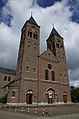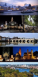
Maastricht is a city and a municipality in the southeastern Netherlands. It is the capital and largest city of the province of Limburg. Maastricht is located on both sides of the Meuse, at the point where the Jeker joins it. Mount Saint Peter (Sint-Pietersberg) is largely situated within the city's municipal borders. Maastricht is adjacent to the border with Belgium. It is part of the Meuse-Rhine Euroregion, a metropolis with a population of about 3.9 million, which includes the nearby German and Belgian cities of Aachen, Liège and Hasselt.

Geleen is a city in the southern part of the province of Limburg in the Netherlands. With 31,670 inhabitants in 2020, it is part of the municipality of Sittard-Geleen. Geleen is situated along the river Geleenbeek, a right tributary to the river Meuse. The Latin name for Geleenbeek is Glana, meaning "clear river". The town centre is situated at about 60 m above sea level.

Heel is a town and former municipality in the southeastern Netherlands. The town is located near the E25 motorway and the river Meuse.
Spaubeek is a village in the Dutch province of Limburg. It is located in the municipality of Beek, about 3 km south of the town of Geleen. Spaubeek was a separate municipality until 1982, when it was merged with Beek. There was an early station of the Poor Handmaids of Jesus Christ caring medically for the population.

Berg en Terblijt is the official Dutch name of a village in the municipality of Valkenburg aan de Geul in the province of Limburg in the Southern part of the Netherlands.

A former village, Amby is now a neighborhood of Maastricht, in the Netherlands, located about 4 km northeast of the center of the city.

Gulpen is a village in the Dutch province of Limburg. It is approximately midway between the Dutch city of Maastricht and the German city of Aachen.

Noorbeek is a village in the Dutch province of Limburg. It is located in the municipality of Eijsden-Margraten and about 12 km southeast of Maastricht. Noorbeek is one of the southernmost villages of the Netherlands and was named after the nearby river Noor.
Oud-Vroenhoven is former municipality in the Dutch province of Limburg. It merged with Maastricht in 1920.
Sint Pieter is a neighbourhood in the city of Maastricht, in the Dutch province of Limburg. It is located on the western bank of the river Meuse, in the south of the city, and borders Belgium. It is a relatively affluent neighbourhood.

Huerta de Rey is a municipality and town located in the province of Burgos, Castile and León, Spain. According to the 2004 census (INE), the municipality has a population of 1,208 inhabitants.
Avshar is a major village in the Ararat Province of Armenia. It hosted the 1993 and 1995 CYMA – Canadian Youth Mission to Armenia led by Archbishop Hovnan Derderian and Ronald Alepian.
Dębina Zakrzowska is a village in the administrative district of Gmina Wojnicz, within Tarnów County, Lesser Poland Voivodeship, in southern Poland.
The Rural Municipality of Silver Creek is a former rural municipality (RM) in the Canadian province of Manitoba. It was originally incorporated as a rural municipality on December 22, 1883. It ceased on January 1, 2015 as a result of its provincially mandated amalgamation with the RM of Shellmouth-Boulton to form the Rural Municipality of Riding Mountain West.
Heers is a hamlet in the south of the municipality of Veldhoven in the province of North Brabant, the Netherlands. Most of the buildings are concentrated around a town square with trees. At this town square is a chapel from 1990 located. There is also a monument, erected in 1966 for the local agricultural consolidation project. Heers has a long history. The hamlet is mentioned in books from the Middle Ages. Also, archaeological artefacts from the Bronze Age and the Roman Empire have been unearthed near the hamlet.

Bukova Glava is a village in the municipality of Leskovac, Serbia. According to the 2002 census, the village has a population of 295 people.
Zlopoljac is a village in the municipality of Bihać, Bosnia and Herzegovina.
Eyserheide is a hamlet in the southeastern Netherlands. It is located close to the village of Eys in the municipality of Gulpen-Wittem, Limburg, around 15 km east of Maastricht. The name refers to a former heathland in the area. The village has a population of 90 people.

Beutenaken is a hamlet in the southeastern Netherlands. It is part of the village of Slenaken in the municipality of Gulpen-Wittem, Limburg, about 20 km east of Maastricht. Older names for the village are Bottinachs, Butenacho and Butenachen. In 2003 the village had a population of 90.

The Stadhuis is the town hall in the centre of Maastricht in the Netherlands. It is sited on the Markt. The building was designed by Pieter Post in the 17th century in the style of Dutch classicism.