Heidenheim, Bavaria

Last updated • 1 min readFrom Wikipedia, The Free Encyclopedia
Heidenheim
Wappen von Heidenheim (Mittelfranken).svg
Location of Heidenheim within Weißenburg-Gunzenhausen district
Heidenheim in WUG.svgBergenHeidenheim
Germany adm location map.svg
Red pog.svg
Heidenheim
Bavaria location map.svg
Red pog.svg
Heidenheim
Coordinates: 49°1′N10°45′E / 49.017°N 10.750°E / 49.017; 10.750
Country Germany
State Bavaria
Admin. region Mittelfranken
District Weißenburg-Gunzenhausen
Municipal assoc. Hahnenkamm
Subdivisions4 Ortsteile
Government
   Mayor (202026) Susanne Feller [1]
Area
  Total
52.29 km2 (20.19 sq mi)
Elevation
529 m (1,736 ft)
Population
 (2023-12-31) [2]
  Total
2,580
  Density49/km2 (130/sq mi)
Time zone UTC+01:00 (CET)
  Summer (DST) UTC+02:00 (CEST)
Postal codes
91719
Dialling codes 09833
Vehicle registration WUG
Website Markt Heidenheim am Hahnenkamm

Heidenheim (German pronunciation: [ˈhaɪdn̩ˌhaɪm] ) is a market town in central-western Bavaria, Germany. It is sometimes known as Heidenheim am Hahnenkamm to avoid confusion with nearby Heidenheim an der Brenz in Baden-Württemberg.

Contents

Geography

Heidenheim is located in the administrative district of Middle Franconia. It belongs to the Weißenburg-Gunzenhausen district and is the seat of the Hahnenkamm municipal association. Heidenheim includes the local subdistricts of Degersheim, Hechlingen am See, and Hohentrüdingen.

History

Heidenheim was first mentioned in the year 742. During that time, the double monastery of Heidenheim am Hahnenkamm (housing monks and nuns) was founded by Saint Willibald and was later led by Saint Walpurga, who became abbess after his death. [3] Secular power was represented in turn by the Earl of Truhendingen (Altentrühdingen), the Duke of Bavaria, and the Hohenzollern burgrave of Nuremberg. Thereafter, the town belonged to the Principality of Ansbach. The monastery was closed in 1537 due to the Reformation. Since then, Heidenheim has been mostly Lutheran. In 1792, Prussia bought the Principality of Ansbach, bringing Heidenheim under Prussian rule. As part of Ansbach, Heidenheim was transferred back to Bavaria due to the Treaty of Paris (1806)  [ de ].

See also

Related Research Articles

<span class="mw-page-title-main">Middle Franconia</span> Regierungsbezirk in Bavaria, Germany

Middle Franconia is one of the three administrative regions of Franconia, Germany, in the west of Bavaria bordering the state of Baden-Württemberg. The administrative seat is Ansbach; the most populous and largest city is Nuremberg.

<span class="mw-page-title-main">Eichstätt</span> Town in Bavaria, Germany

Eichstätt is a town in the federal state of Bavaria, Germany, and capital of the district of Eichstätt. It is located on the Altmühl river and has a population of around 13,000. Eichstätt is also the seat of the Roman Catholic Diocese of Eichstätt.

<span class="mw-page-title-main">Heilsbronn</span> Town in Bavaria, Germany

Heilsbronn is a town in the Ansbach district of the Mittelfranken administrative region of Franconia, in the German state of Bavaria between Nuremberg and Ansbach, in the wooded valley of the Rangau. Its hallmark is the Katharinenturm, a medieval tower.

<span class="mw-page-title-main">Feuchtwangen</span> Town in Bavaria, Germany

Feuchtwangen is a city in Ansbach district in the administrative region of Middle Franconia in Bavaria, Germany with around 12,000 citizens and 137km² of landmass making it the biggest city in the Ansbach district by Population and Landmass. In the year 2019 Feuchtwangen celebrated its 1200th jubilee based on the first mention of its Benedictine monastery.

<span class="mw-page-title-main">Schäftlarn</span> Municipality in Bavaria, Germany

Schäftlarn is a municipality in the district of Munich in Bavaria in Germany. It consists of the villages Ebenhausen, Hohenschäftlarn, Kloster Schäftlarn, Neufahrn and Zell. The river Isar runs through it. A human settlement with the name "Schäftlarn" does not exist.

<span class="mw-page-title-main">Abenberg</span> Town in Bavaria, Germany

Abenberg is a town in the Middle Franconian district of Roth, in Bavaria, Germany. It is situated 9 km west of Roth bei Nürnberg and 25 km southwest of Nuremberg.

<span class="mw-page-title-main">Herrieden</span> Town in Bavaria, Germany

Herrieden is a town in the district of Ansbach and situated in the Middle Franconia region of Bavaria, Germany. It lies along the upper Altmühl river, about 9 km (6 mi) southwest of the city of Ansbach, 47 km southwest of the city of Nürnberg, 95 km east of Heilbronn and 144 km northwest of Munich.

<span class="mw-page-title-main">Wassertrüdingen</span> Town in Bavaria, Germany

Wassertrüdingen is a town in the district of Ansbach, Middle Franconia, Bavaria, Germany. It is between the Hesselberg, the only Franconian mountain with a view on the Alps, the wooded heights of the Oettinger Forest and the foothills of the Hahnenkamm. The Fränkisches Seenland recreation area is 15 kilometers away. Altentrüdingen, Fürnheim, Geilsheim, Obermögersheim, Reichenbach und Schobdach are part of Wassertrüdingen

<span class="mw-page-title-main">Ornbau</span> Town in Bavaria, Germany

Ornbau is a walled town in the district of Ansbach, in Bavaria, Germany. It is situated on the river Altmühl, 15 km southeast of Ansbach.

<span class="mw-page-title-main">Andechs</span> Municipality in Bavaria, Germany

Andechs is a municipality in the district of Starnberg in Bavaria in Germany. It is renowned in Germany and beyond for Andechs Abbey, a Benedictine monastery that has brewed beer since 1455. The monastery brewery offers tours to visitors.

<span class="mw-page-title-main">Buch am Wald</span> Municipality in Bavaria, Germany

Buch am Wald is a municipality in the district of Ansbach in Bavaria in Germany.

<span class="mw-page-title-main">Schnelldorf</span> Municipality in Bavaria, Germany

Schnelldorf is a municipality in the district of Ansbach in Mittelfranken in Bavaria in Germany. It neighbours to Feuchtwangen, Wörnitz and Wettringen (Mittelfranken) in Bavaria and Rot am See, Wallhausen, Baden-Württemberg, Satteldorf and Kreßberg

<span class="mw-page-title-main">Weidenbach, Bavaria</span> Municipality in Bavaria, Germany

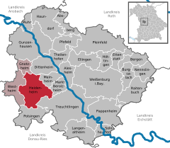
Weidenbach is a municipality in the district of Ansbach in Bavaria in Germany.

<span class="mw-page-title-main">Aura an der Saale</span> Municipality in Bavaria, Germany

Aura an der Saale is a municipality in the district of Bad Kissingen in Bavaria in Germany.

<span class="mw-page-title-main">Altomünster</span> Municipality in Bavaria, Germany

Altomünster is a municipality in the district of Dachau in Bavaria in Germany.

<span class="mw-page-title-main">Neunkirchen am Brand</span> Municipality in Bavaria, Germany

Neunkirchen am Brand is a municipality in the district of Forchheim in Bavaria in Germany.

<span class="mw-page-title-main">Neustadt am Main</span> Municipality in Bavaria, Germany

Neustadt am Main is a community in the Main-Spessart district in the Regierungsbezirk of Lower Franconia (Unterfranken) in Bavaria, Germany and a member of the Verwaltungsgemeinschaft Lohr am Main.

<span class="mw-page-title-main">Roden, Bavaria</span> Municipality in Bavaria, Germany

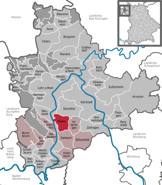
Roden is a community in the Main-Spessart district in the Regierungsbezirk of Lower Franconia (Unterfranken) in Bavaria, Germany and a member of the Verwaltungsgemeinschaft of Marktheidenfeld.

<span class="mw-page-title-main">Rinchnach</span> Municipality in Bavaria, Germany

Rinchnach is a municipality in the Lower Bavarian district of Regen, of Germany. As of 2000, the population was 3,261.

<span class="mw-page-title-main">Mallersdorf-Pfaffenberg</span> Municipality in Bavaria, Germany

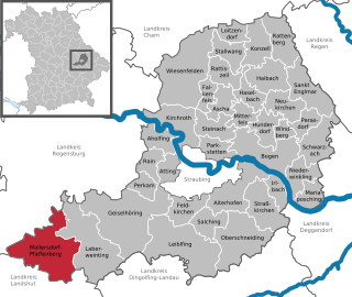
Mallersdorf-Pfaffenberg is a municipality in the district of Straubing-Bogen in Bavaria, Germany and has around 7,000 inhabitants.

References

  1. Liste der ersten Bürgermeister/Oberbürgermeister in kreisangehörigen Gemeinden, Bayerisches Landesamt für Statistik, 15 July 2021.
  2. Genesis Online-Datenbank des Bayerischen Landesamtes für Statistik Tabelle 12411-003r Fortschreibung des Bevölkerungsstandes: Gemeinden, Stichtag (Einwohnerzahlen auf Grundlage des Zensus 2011).
  3. Proksch, Nikola (1997). "The Anglo-Saxon Missionaries on the Continent". Monks of England: The Benedictines in England from Augustine to the Present Day. Society for Promoting Christian Knowledge. pp. 37–54.