Hells Canyon Scenic Byway

Last updated

MUTCD D6-4.svg

Hells Canyon Scenic Byway

Hells Canyon Scenic Byway
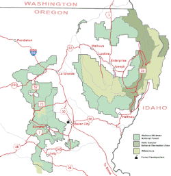
Hells Canyon Scenic Byway highlighted in red
Route information
Maintained by Oregon Department of Transportation,
Oregon Parks and Recreation Department, etc.
Length218.4 mi [1]  (351.5 km)
ExistedApril 19, 1992 [2] –present
Major junctions
West endI-84.svgOR 82.svg I-84  / OR 82 near La Grande
East endI-84.svgOR 86.svg I-84  / OR 86 near Baker City
Location
Country United States
State Oregon
Counties Union, Wallowa, Baker
Highway system

Hells Canyon Scenic Byway is a designated All-American Road in the U.S. state of Oregon. It is located at the northeast corner of Oregon and comprises Oregon Route 82, Oregon Route 350, Forest Roads 39 and 3365, and most of Oregon Route 86. From the west, the byway begins at the intersection of Oregon Route 82 and Interstate 84 near La Grande and ends near Baker City, at the junction of Interstate 84 and Oregon Route 86. It is 218.4 miles (351.5 km) long. [1]

Contents

Route description

Along its route, Hells Canyon Scenic Byway hugs the Wallowa River, runs through the Wallowa-Whitman National Forest, and goes near Wallowa Lake, Salt Creek Summit, Hells Canyon Overlook and the Eagle Cap Wilderness Area.

Hells Canyon OR hells canyon.jpg
Hells Canyon
Map of Wallowa-Whitman National Forest, including the Hells Canyon area Wallowa-Whitman National Forest map.gif
Map of Wallowa-Whitman National Forest, including the Hells Canyon area

History

The Hells Canyon Scenic Byway was designated a National Forest Scenic Byway on April 19, 1992. It was later made an Oregon State Scenic Byway on February 19, 1997. The All-American Road designation was applied to the roadway on June 15, 2000. [2]

See also

Related Research Articles

<span class="mw-page-title-main">California State Route 74</span> Highway in California

State Route 74, part of which forms the Palms to Pines Scenic Byway or Pines to Palms Highway, and the Ortega Highway, is a state highway in the U.S. state of California. It runs from Interstate 5 in San Juan Capistrano in Orange County to the city limits of Palm Desert in Riverside County. Stretching about 111 miles (179 km), it passes through several parks and National Forests between the Pacific coast and the Coachella Valley.

<span class="mw-page-title-main">California State Route 38</span> Highway in California

State Route 38 is a mostly rural and scenic state highway in the U.S. state of California, connecting Interstate 10 in Redlands with State Route 18 in the Big Bear Lake area. It is one of the primary routes into the San Bernardino Mountains. Despite the orientation of its alignment, SR 38 is assigned in a west–east direction.

<span class="mw-page-title-main">U.S. Route 189</span> Highway in the United States

U.S. Route 189 is a spur of U.S. Route 89. It currently runs for 322 miles (518 km) from Provo, Utah at Interstate 15 to Jackson, Wyoming. The highway was not part of the original 1926 U.S. Highway system. The highway was created in the 1930s, absorbing former U.S. Route 530 and a portion of U.S. Route 30S. The portion through Provo Canyon has been designated the Provo Canyon Scenic Byway by the state of Utah.

<span class="mw-page-title-main">California State Route 120</span> Highway in California

State Route 120 is a state highway in the central part of California, connecting the San Joaquin Valley with the Sierra Nevada, Yosemite National Park, and the Mono Lake area. Its western terminus is at Interstate 5 in Lathrop, and its eastern terminus at U.S. Route 6 in Benton. While the route is signed as a contiguous route through Yosemite, the portion inside the park is federally maintained and is not included in the state route logs. The portion at Tioga Pass at Yosemite's eastern boundary is the highest paved through road in the California State Route system. This part is not maintained in the winter and is usually closed during the winter season.

The State Scenic Highway System in the U.S. state of California is a list of highways, mainly state highways, that have been designated by the California Department of Transportation (Caltrans) as scenic highways. They are marked by the state flower, a California poppy, inside either a rectangle for state-maintained highways or a pentagon for county highways.

<span class="mw-page-title-main">McKenzie Pass–Santiam Pass Scenic Byway</span>

The McKenzie Pass–Santiam Pass Scenic Byway is an 82-mile-long (132 km) National Scenic Byway in the U.S. state of Oregon. The route is a loop designed to provide a tour of the high Cascade Range northwest of Bend, passing over both McKenzie Pass and Santiam Pass.

<span class="mw-page-title-main">Interstate 84 (Oregon–Utah)</span> Interstate Highway in the U.S. states of Oregon, Idaho, and Utah

Interstate 84 (I-84) is an Interstate Highway in the northwestern United States. The highway runs from Portland, Oregon, to a junction with I-80 near Echo, Utah. The highway serves and connects Portland, Boise, and Ogden, Utah. With connections to other highways, I-84 connects these cities to points east and also serves as part of a corridor between Seattle and Salt Lake City. The sections running through Oregon and Idaho are also known as the Vietnam Veterans Memorial Highway.

<span class="mw-page-title-main">California State Route 33</span> Highway in California

State Route 33 is a north–south state highway in the U.S. state of California. It runs north from U.S. Route 101 in Ventura through the Transverse Ranges and the western side of the San Joaquin Valley to Interstate 5 at a point east of Tracy. SR 33 replaced part of U.S. Route 399 in 1964 during the "great renumbering" of routes. In the unincorporated sections of Kern County it is known as the West Side Highway. In addition, the California Legislature designated the entire Kern County portion as the Petroleum Highway in 2004. The southernmost portion in Ventura is a freeway known as the Ojai Freeway, while it is known as the Maricopa Highway from Ojai to Maricopa.

<span class="mw-page-title-main">Mount Hood Highway</span>

The Mount Hood Highway No. 26 is the Oregon Department of Transportation's designation for a 96.74-mile-long (155.69 km) highway from Portland east around the south side of Mount Hood and north via Bennett Pass to Hood River. It is marked as U.S. Route 26 from Portland to near Mount Hood and Oregon Route 35 the rest of the way to Hood River.

<span class="mw-page-title-main">California State Route 96</span> Highway in California

State Route 96 is a state highway in the U.S. state of California that follows the Trinity and Klamath Rivers between State Route 299 in Willow Creek and Interstate 5 near Yreka in Northern California. For most of the route it goes through the Karuk Tribal Reservation, the Yurok Tribal Reservation, and the Hoopa Tribal Reservation. Over half of the length is the Bigfoot Scenic Byway, passing through "the region boasting the most sightings of Bigfoot of anywhere in the country" according to the National Forest Scenic Byway Program.

<span class="mw-page-title-main">Oregon Route 82</span> Highway in Oregon

Oregon Route 82 (OR 82) is a 70.74-mile-long (113.84 km) state highway in the northeastern part of the U.S. state of Oregon. It travels from U.S. Route 30 (US 30) at La Grande to an intersection with Oregon Routes 350 and 351 in Joseph. It is known as the Wallowa Lake Highway No. 10. OR 82 is part of the Hells Canyon Scenic Byway.

<span class="mw-page-title-main">Arizona State Route 67</span> State highway in Arizona, United States

State Route 67 is a 43.4 mi (69.8 km) long, north–south state highway in northern Arizona. Also called the Kaibab Plateau – North Rim Parkway, SR 67 is the sole road that links U.S. Route 89A at Jacob Lake to the North Rim of Grand Canyon National Park. Along the route, the road heads through the national park as well as Kaibab National Forest and traverses extensive coniferous forests. The section inside the national park is maintained by the National Park Service (NPS), whereas the section north of the entrance, completely within Kaibab National Forest, is owned by the Arizona Department of Transportation (ADOT). The road was built in the late 1920s and improved through the 1930s. In 1941, the road received its number, and was given its designation as the parkway in the 1980s. The parkway has received designations as a National Forest Scenic Byway as well as a National Scenic Byway.

<span class="mw-page-title-main">Imnaha River</span> Tributary of the Snake River in Oregon

The Imnaha River is a 73.3-mile-long (118.0 km) tributary of the Snake River in the U.S. state of Oregon. Flowing generally east near the headwaters and then north through Wallowa County, the entire river is designated Wild and Scenic. It follows a geologic fault to the Snake River, and in addition to land in the Wallowa–Whitman National Forest and private land, its corridor includes parts of three special management areas: the Eagle Cap Wilderness, Hells Canyon National Recreation Area, and Hells Canyon Scenic Byway. The Imnaha flows by the unincorporated community of Imnaha, the only settlement along its course, and enters the Snake River roughly 4 miles (6 km) from the larger river's confluence with the Salmon River of Idaho and 192 miles (309 km) from its confluence with the Columbia River.

<span class="mw-page-title-main">Oregon Route 86</span> Highway in Oregon

Oregon Route 86 is an Oregon state highway running from Interstate 84 at Baker City to the Idaho state line at Oxbow. OR 86 comprises most of the Baker-Copperfield Highway No. 12. It is 67.82 miles (109.15 km) long and runs east–west. OR 86 has an unsigned spur near Halfway, which runs for 1.15 miles (1.85 km). Most of OR 86 is part of the Hells Canyon Scenic Byway.

<span class="mw-page-title-main">Talimena Scenic Drive</span> Scenic byway in the Ouachita Mountains

The Talimena Scenic Drive is a National Scenic Byway in southeastern Oklahoma and extreme western Arkansas spanning a 54.0-mile (86.9 km) stretch of Oklahoma State Highway 1 (SH-1) and Arkansas Highway 88 (AR 88) from Talihina, Oklahoma, to Mena, Arkansas.

<span class="mw-page-title-main">U.S. Route 30 in Idaho</span> US Highway section within the state of Idaho

U.S. Route 30 (US 30) runs northwest–southeast across the southern half of lower Idaho for 455.481 miles (733.026 km). US 30 enters the state from Oregon across the Snake River in Fruitland and exits into Wyoming east of Dingle. US 30 runs through the large population centers of Boise, Twin Falls, and Pocatello, as well as a plethora of smaller communities from Fruitland to Montpelier. The Thousand Springs Scenic Byway is a picturesque section of US 30 in southern Idaho between the towns of Bliss and Buhl, dipping down into the Hagerman Valley and a canyon of the Snake River.

<span class="mw-page-title-main">Utah State Route 143</span> Highway in Utah

State Route 143 (SR-143) is a state highway in the U.S. state of Utah. The entire highway has been designated the Brian Head-Panguitch Lake Scenic Byway as part of the Utah Scenic Byways program. This road has also been designated as Utah's Patchwork Parkway as part of the National Forest Scenic Byway and National Scenic Byway programs.

<span class="mw-page-title-main">Colorado State Highway 65</span> State highway in Colorado, United States

State Highway 65 (SH 65) is a state highway in Colorado that crosses the Grand Mesa. The highway along with a road to Lands End Overlook were designated as the Grand Mesa National Scenic Byway in 1996. SH 65's southern terminus is at SH 92 east of Delta, and its northern terminus is at Interstate 70 (I-70) and U.S. Route 6 (US 6) northeast of Palisade.

<span class="mw-page-title-main">Rogue-Umpqua Scenic Byway</span>

The Rogue-Umpqua Scenic Byway is a National Scenic Byway in the U.S. state of Oregon. It provides a tour of the environs of the North Umpqua River, the High Cascades, and the Upper Rogue River.

References

Template:Attached KML/Hells Canyon Scenic Byway
KML is not from Wikidata
  1. 1 2 Staff. "Hells Canyon Scenic Byway". National Scenic Byways. Federal Highway Administration. Retrieved May 13, 2008.
  2. 1 2 Staff. "Official Designations". Hells Canyon Scenic Byway. Federal Highway Administration . Retrieved September 11, 2011.