Helmer, Michigan

Last updated

Helmer, Michigan
Helmer, Michigan.jpg
Helmer signage looking west along H-44
USA Michigan location map.svg
Red pog.svg
Helmer
Location within the state of Michigan
Usa edcp location map.svg
Red pog.svg
Helmer
Location within the United States
Coordinates: 46°15′59″N85°42′56″W / 46.26639°N 85.71556°W / 46.26639; -85.71556
CountryUnited States
State Michigan
County Luce
Township Lakefield
Settled1881
Established1894
Elevation
689 ft (210 m)
Time zone UTC-5 (Eastern (EST))
  Summer (DST) UTC-4 (EDT)
ZIP code(s)
49853 (McMillan)
Area code 906
GNIS feature ID628066 [1]

Helmer is an unincorporated community in Luce County in the U.S. state of Michigan. [1] The community is located within Lakefield Township. As an unincorporated community, Helmer has no legally defined boundaries or population statistics of its own.

Contents

History

Helmer appearing on a Luce County map from 1911 Luce County, MI map (1911).jpg
Helmer appearing on a Luce County map from 1911

The area was first settled as early as 1881 when Presbyterian minister Roy Mills built a mission house along Helmer Creek. [2] At the time, the area was part of western Chippewa County until Luce County was created in 1887. [3]

Helmer received its first post office on March 19, 1894 with Gaylord Helmer serving as the first postmaster until March 19, 1899. Charles Fyvie served as postmaster from June 25, 1907 until the Helmer post office was discontinued on September 30, 1914. [4] The post office served as a rural branch of the McMillan post office until it was ultimately discontinued in 1920. [2] [5]

When the railway industry began constructing lines through the Upper Peninsula near the end of the century, Helmer did not have railroad access, and the nearest railway depot was to the north in McMillan. Helmer served as a small resort community with a stagecoach stop for travelers. Road access to Helmer was limited until M-98 was commissioned in 1919, which connected Helmer to M-77 to the west and M-28 to the northeast. [6] In 1929, M-135 was commissioned to further connect Helmer to M-28 and also U.S. Route 2 to the south. [7] Both M-98 and M-135 were decommissioned in 1960 and turned over to county control and are now known as H-44 and H-33 respectively.

Helmer continues to exist as an unincorporated community within Lakefield Township and contains a small population and a few businesses. The East Lakefield Cemetery is located near Helmer just to the east. It is an active cemetery with its earliest grave dating back to 1900. [8]

Helmer House Inn

Helmer House Inn
Helmer House (Michigan) June 2021.jpg
Helmer House Inn in June 2021
Location2747 County Road 377
McMillan, Michigan
Coordinates 46°16′13″N85°43′08″W / 46.27028°N 85.71889°W / 46.27028; -85.71889
Built1881
DesignatedJanuary 13, 1982

The most notable structure within the community of Helmer is the Helmer House Inn, which is located along Helmer Creek just north of Manistique Lake at 2747 Helmer Road (County Road 377). The building was constructed in 1881–1882 as a mission house and manse by Roy Mills of the Presbyterian church from Newberry. It served in this capacity until 1888 when it was purchased by local sheriff Gaylord Helmer. He converted the structure into a general store and hotel. In 1894, Helmer added a second structure to the original house to accommodate more travelers, as well as housing the community's first post office with himself as postmaster. [5] [9]

In 1904, the general store was purchased by Charles and Jeanie Fyvie. The Helmer post office, which was established in 1894, was located within the structure until it was ultimately discontinued as a rural branch in 1920. The Fyvie family continued to live there and operated the hotel and general store until it closed in 1950. [2] After it closed, it remained unused and fell into disrepair. The structure was restored in 1981 and reopened as a hotel to commemorate its centennial anniversary. It was then designated as a Michigan State Historic Site on January 13, 1982. A state historic marker was also erected on the site. [9] [10]

The hotel closed down a few years later, and the building became neglected and fell into disrepair again. In 2017, the building was at risk of being demolished until local residents James and Kristen Handrich purchased and restored the structure by the following year. The building reopened in 2020 as the Helmer House Inn & Cafe, which serves as a bakery and provides bed and breakfast accommodations. [5] In 2020, the Helmer House Inn & Cafe was awarded as having the Upper Peninsula's best doughnuts. [11]

Geography

Helmer is a small community located within Lakefield Township in the state's Upper Peninsula about 15 miles (24.1 km) west of the village of Newberry. The community is surrounded by portions of the Sault Ste. Marie section of the Lake Superior State Forest. [12] Helmer sits at an elevation of 689 feet (210 m) above sea level. [1]

Helmer is located along the northeast shores of Manistique Lake along H-33 (Manistique Lakes Road) and the western terminus of H-44 (Ten Curves Road). Aside from Newberry, the nearest sizable communities include McMillan to the north, Curtis to the south, Engadine to the southeast, and Germfask and Seney to the west. M-28 crosses east–west about 6 miles (9.7 km) to the north, and M-117 runs south–north about 10 miles (16.1 km) to the east.

Helmer no longer contains its own post office and uses the McMillan 49853 ZIP Code. [13] The community is served by Tahquamenon Area Schools in Newberry, which serves the entire county itself and has the largest area of any public school district in the state. [14] [15]

Along with Manistique Lake, other nearby geographic features include the short Helmer Creek, which connects Manistique Lake to North Manistique Lake to the north. [16] Locke Creek is the only tributary of Helmer Creek and joins the creek within the community. [17] Fork Lake and Fork Creek are small waterways that serve as tributaries connecting to the northeastern portion of Manistique Lake near Helmer. [18] [19]

Related Research Articles

<span class="mw-page-title-main">Luce County, Michigan</span> County in Michigan, United States

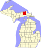
Luce County is a county located in the Upper Peninsula in the U.S. state of Michigan. As of the 2020 census, the population was 5,339, making it the second-least populous county in Michigan. The county seat is Newberry, Luce County's only incorporated community. The county was set off and organized in 1887 and named after former Michigan Governor Cyrus G. Luce.

<span class="mw-page-title-main">Whitefish Township, Michigan</span> Civil township in Michigan, United States

Whitefish Township is a civil township of Chippewa County in the U.S. state of Michigan. The population was 474 at the 2020 census.

<span class="mw-page-title-main">Newberry, Michigan</span> Village in Michigan, United States

Newberry is a village and county seat of Luce County in the U.S. state of Michigan. The village is located within McMillan Township and is the only incorporated community in Luce County. The population was 1,446 at the 2020 census.

<span class="mw-page-title-main">Swan Creek Township, Michigan</span> Civil township in Michigan, United States

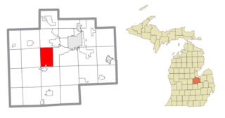
Swan Creek Township is a civil township of Saginaw County in the U.S. state of Michigan. The population was 2,456 at the 2010 Census.

<span class="mw-page-title-main">Curtis, Michigan</span> Unincorporated community in Michigan, United States

Curtis is an unincorporated community in Mackinac County in the U.S. state of Michigan. The community is located within Portage Township. As an unincorporated community, Curtis has no legally defined boundaries or population statistics of its own but does have its own post office with the 49820 ZIP Code.

<span class="mw-page-title-main">M-98 (Michigan highway)</span> Former state highway in Schoolcraft and Luce counties in Michigan, United States

M-98 is the designation of a former 16.2-mile (26.1 km) state trunkline highway in the Upper Peninsula of the US state of Michigan. It ran between M-77 at Germfask and M-28 near McMillan. The highway connected both small towns situated around Manistique Lake when it was designated with the rest of the original state highways in 1919. The section north of Helmer on the east side of the lake ran concurrently with M-135 after the latter's creation in the late 1920s. M-98 was extended at the end of the 1940s before the whole trunkline was removed from the highway system in the 1960s. Since the 1970s, part of M-98 has been designated as one of the two County Road H-44s in the state.

<span class="mw-page-title-main">McMillan, Michigan</span> Unincorporated community in Michigan, United States

McMillan is an unincorporated community in Luce County in the U.S. state of Michigan. The community is located along M-28 within Columbus Township. As an unincorporated community, McMillan has no legally defined boundaries or population statistics of its own but does have its own post office with the 49853 ZIP Code.

<span class="mw-page-title-main">Dollarville, Michigan</span> Unincorporated community in Michigan, United States

Dollarville is an unincorporated community in Luce County in the U.S. state of Michigan. The community is located within McMillan Township just west of the village of Newberry along County Road 405. As an unincorporated community, Dollarville has no legally defined boundaries or population statistics of its own.

<span class="mw-page-title-main">H-33 (Michigan county highway)</span> County highway in Mackinac and Luce counties in Michigan, United States

H-33 is a county-designated highway in the Upper Peninsula of the US state of Michigan between Gould City and McMillan that was previously M-135, a former state trunkline highway. The roadway follows Manistique Lakes Road from Gould City at a junction with US Highway 2 (US 2) near Lake Michigan north to M-28 near McMillan. The northern section of the highway is also called County Road 135 (CR 135) in Luce County.

<span class="mw-page-title-main">Manistique River</span> River in Michigan

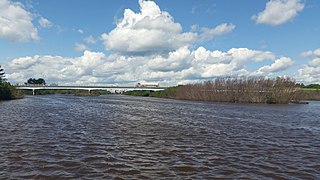
The Manistique River is a 71.2-mile-long (114.6 km) river in the U.S. state of Michigan that winds southward through the central Upper Peninsula from its headwaters near Lake Superior to its mouth in Lake Michigan. It drains approximately 1,461 square miles (3,780 km2) of the Upper Peninsula, including most of Schoolcraft County and small portions of Alger County, Delta County, Luce County, and Mackinac County. The river rises at the outlet of Manistique Lake in the southwest corner of Luce County, and after flowing through the Seney National Wildlife Refuge, empties into Lake Michigan at Manistique, Michigan. M-77, a north–south highway, serves much of the Manistique River's drainage and crosses the river and its tributaries several times.

<span class="mw-page-title-main">Engadine, Michigan</span> Unincorporated community in Michigan, United States

Engadine is an unincorporated community in Mackinac County in the U.S. state of Michigan. The community is located within Garfield Township. As an unincorporated community, Engadine has no legally defined boundaries or population statistics of its own but does have its own post office with the 49827 ZIP Code.

<span class="mw-page-title-main">Naubinway, Michigan</span> Census-designated place & unincorporated community in Michigan, United States

Naubinway is an unincorporated community and census-designated place (CDP) in Mackinac County in the U.S. state of Michigan. The population of the CDP was 147 at the 2020 census, which was the first year that it was recorded by the census. The community is located within Garfield Township.

<span class="mw-page-title-main">Garnet, Michigan</span> Unincorporated community in Michigan, United States

Garnet is an unincorporated community in Mackinac County in the U.S. state of Michigan. The community is located within Hudson Township. As an unincorporated community, Garnet has no legally defined boundaries or population statistics of its own.

<span class="mw-page-title-main">Deer Park, Michigan</span> Unincorporated community in Michigan, United States

Deer Park is an unincorporated community in Luce County in the U.S. state of Michigan. The community is located within McMillan Township. As an unincorporated community, Deer Park has no legally defined boundaries or population statistics of its own.

<span class="mw-page-title-main">Manistique Lake</span> Lake in the state of Michigan, United States

Manistique Lake, locally called Big Manistique Lake to distinguish it from the other lakes in the Manistique Lakes system, is a 10,130-acre (4,100 ha) lake in the Upper Peninsula of the U.S. state of Michigan. Approximately 6.5 miles (10.5 km) long and 4 miles (6.4 km) wide, it is one of the largest lakes in the Upper Peninsula. Elevated 686 feet (209 m) above sea level and 105 feet (32 m) above Lake Michigan, Manistique Lake drains into the larger lake through a marshy outlet on the west end of the lake that forms one source of the Manistique River. Relatively shallow, the lake's deepest point is only 20 feet (6.1 m) below the water surface. The average depth is 10 feet (3.0 m).

<span class="mw-page-title-main">Columbus Township, Luce County, Michigan</span> Civil township in Michigan, United States

Columbus Township is a civil township of Luce County in the U.S. state of Michigan. As of the 2020 census, the township population was 169.

<span class="mw-page-title-main">Lakefield Township, Luce County, Michigan</span> Civil township in Michigan, United States

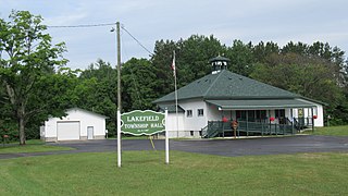
Lakefield Township is a civil township of Luce County in the U.S. state of Michigan. The population was 1,135 at the 2020 census, an increase from 1,061 at the 2010 census.

<span class="mw-page-title-main">McMillan Township, Luce County, Michigan</span> Civil township in Michigan, United States

McMillan Township is a civil township of Luce County in the U.S. state of Michigan. The population was 2,471 at the 2020 census. At 588.78 square miles (1,524.9 km2) of total land area, McMillan Township is the largest municipality by area in the state of Michigan.

<span class="mw-page-title-main">Portage Township, Mackinac County, Michigan</span> Civil township in Michigan, United States

Portage Township is a civil township of Mackinac County in the U.S. state of Michigan. As of the 2020 census, its population was 907, down from 981 in 2010.

There are three Manistique Lakes in the Upper Peninsula of Michigan. The lakes include North Manistique Lake, Big Manistique Lake, and South Manistique Lake. The towns surrounding the lakes are Curtis, Germfask, and Helmer. The lakes are known for vacationing and fishing. They are also in close proximity to other natural sights such as the Great Lakes, rivers, and smaller lakes as well as tourist attractions including the Canada–US border, the Soo Locks, Mackinac Island, parks, and museums.

References

  1. 1 2 3 U.S. Geological Survey Geographic Names Information System: Helmer, Michigan
  2. 1 2 3 Romig, Walter (October 1, 1986) [1973]. Michigan Place Names: The History of the Founding and the Naming of More Than Five Thousand Past and Present Michigan Communities (Paperback). Detroit, Michigan: Wayne State University Press. pp. 260–261. ISBN   978-0-8143-1838-6.
  3. "Bibliography on Luce County". Clarke Historical Library, Central Michigan University . Retrieved July 17, 2013.
  4. U.S. Geological Survey Geographic Names Information System: Helmer Post Office (historical)
  5. 1 2 3 Helmer House Inn (2020). "Helmer House Inn History" . Retrieved August 2, 2021.
  6. Michigan State Highway Department (July 1, 1919). State of Michigan (Map). Scale not given. Lansing: Michigan State Highway Department. Upper Peninsula sheet. OCLC   15607244 . Retrieved December 18, 2016 via Michigan State University Libraries.
  7. Michigan State Highway Department (May 1, 1929). Official Highway Service Map (Map). [c. 1:810,000]. Lansing: Michigan State Highway Department. OCLC   12701195, 79754957.
  8. U.S. Geological Survey Geographic Names Information System: East Lakefield Cemetery
  9. 1 2 MichMarkers.com (2021). "Helmer House Inn: Registered Site L0981" . Retrieved August 2, 2021.
  10. U.S. Geological Survey Geographic Names Information System: Helmer House Inn Historic Marker
  11. "In this U.P. historic landmark you will find a bed and breakfast, cafe and doughnuts". MLive. Booth Newspapers. October 26, 2020. Retrieved August 3, 2021.
  12. Michigan Economic Development Corporation (2021). "Manistique Lakes Area Tourism Bureau: Helmer" . Retrieved July 27, 2021.
  13. Google (July 24, 2021). "49853 ZIP Code map" (Map). Google Maps . Google. Retrieved July 24, 2021.
  14. Michigan Geographic Framework (November 15, 2013). "Luce County School Districts" (PDF). Retrieved July 24, 2021.
  15. State of Michigan (May 22, 2018). "Square mileage of Michigan school districts" (PDF). Retrieved July 21, 2021.
  16. U.S. Geological Survey Geographic Names Information System: Helmer Creek
  17. U.S. Geological Survey Geographic Names Information System: Locke Creek
  18. U.S. Geological Survey Geographic Names Information System: Fork Lake
  19. U.S. Geological Survey Geographic Names Information System: Fork Creek