M-98 (Michigan highway)

Last updated

M-98 1948.svg

M-98
M-98 highlighted in red
Route information
Maintained by MSHD
Length 16.2 mi [1] (26.1 km)
Existedc.July 1, 1919 [2] – c. 1960 [3] [4]
Major junctions
West endM-77 1948.svg M-77 in Germfask
 M-135 1948.svg M-135 in Helmer
East endM-28 1948.svg M-28 near McMillan
Location
Counties Schoolcraft, Luce
Highway system
M-97.svg M-97 M-99 M-99.svg

M-98 is the designation of a former 16.2-mile (26.1 km) state trunkline highway in the Upper Peninsula of the US state of Michigan. It ran between M-77 at Germfask and M-28 near McMillan. The highway connected both small towns situated around Manistique Lake when it was designated with the rest of the original state highways in 1919. The section north of Helmer on the east side of the lake ran concurrently with M-135 after the latter's creation in the late 1920s. M-98 was extended at the end of the 1940s before the whole trunkline was removed from the highway system in the 1960s. Since the 1970s, part of M-98 has been designated as one of the two County Road H-44s in the state.

Upper Peninsula of Michigan Northern major peninsula of the U.S. state of Michigan

The Upper Peninsula (UP), also known as Upper Michigan, is the northern of the two major peninsulas that make up the U.S. state of Michigan. The peninsula is bounded on the north by Lake Superior, on the east by the St. Marys River, and on the southeast by Lake Michigan and Lake Huron. Geographically, the Upper Peninsula has a land boundary with Wisconsin, and over-water boundaries with Minnesota and Ontario (Canada). Upper Peninsula counties also include nearby islands such as Grand, Drummond, Mackinac, and Bois Blanc, and more distant Isle Royale.

Michigan State of the United States of America

Michigan is a state in the Great Lakes and Midwestern regions of the United States. The state's name, Michigan, originates from the Ojibwe word mishigamaa, meaning "large water" or "large lake". With a population of about 10 million, Michigan is the tenth most populous of the 50 United States, with the 11th most extensive total area, and is the largest state by total area east of the Mississippi River. Its capital is Lansing, and its largest city is Detroit. Metro Detroit is among the nation's most populous and largest metropolitan economies.

M-77 (Michigan highway) highway in Michigan, United States

M-77 is a state trunkline highway in the Upper Peninsula (UP) of the US state of Michigan. It starts in US 2 near Blaney Park north of Lake Michigan. The highway borders the eastern edge of the Seney National Wildlife Refuge and passes through the community of Germfask. At Seney, it overlaps M-28 to cross the Fox River before returning northward. The northern half has been designated as a Scenic Spur of the Lake Superior Circle Tour. M-77 runs along the eastern end of the Pictured Rocks National Lakeshore and terminates in Grand Marais north of H-58 near Lake Superior. Originally designated by 1919, the highway has not been changed much in its history. By the late 1950s, the highway was paved, completing the modern M-77 highway.

Contents

Route description

M-98 started at a junction with M-77 in Germfask next to the Seney National Wildlife Refuge, a managed wetland in Schoolcraft County. The highway followed Ten Curves Road east and then north out town. The trunkline turned back due east and crosses the Fox River before a set of curves that shifted the highway along the Schoolcraft–Luce county line to pass north of Big Manistique Lake. Ten Curves Road passes between the Big and North Manistee lakes as it enters the community of Helmer in Luce County. There, M-98 intersected M-135, and the two ran concurrently north along Manistique Lakes Road. M-98/M-135 turned due east to intersect M-28 southwest of McMillan near East Lake. [1] [3]

Seney National Wildlife Refuge

The Seney National Wildlife Refuge is a managed wetland in Schoolcraft County in the U.S. state of Michigan. It has an area of 95,212 acres (385 km2). It is bordered by M-28 and M-77. The nearest town of any size is Seney, Michigan. The refuge contains the Seney Wilderness Area and the Strangmoor Bog National Natural Landmark within its boundaries.

Wetland A land area that is permanently or seasonally saturated with water

A wetland is a distinct ecosystem that is inundated by water, either permanently or seasonally, where oxygen-free processes prevail. The primary factor that distinguishes wetlands from other land forms or water bodies is the characteristic vegetation of aquatic plants, adapted to the unique hydric soil. Wetlands play a number of functions, including water purification, water storage, processing of carbon and other nutrients, stabilization of shorelines, and support of plants and animals. Wetlands are also considered the most biologically diverse of all ecosystems, serving as home to a wide range of plant and animal life. Whether any individual wetland performs these functions, and the degree to which it performs them, depends on characteristics of that wetland and the lands and waters near it. Methods for rapidly assessing these functions, wetland ecological health, and general wetland condition have been developed in many regions and have contributed to wetland conservation partly by raising public awareness of the functions and the ecosystem services some wetlands provide.

Schoolcraft County, Michigan County in the United States

Schoolcraft County is a county located in the Upper Peninsula of the U.S. state of Michigan. As of the 2010 United States Census, the population was 8,485. The county seat is Manistique, which lies along the northern shore of Lake Michigan. The county is named in honor of Henry Schoolcraft, who explored the area with the expedition of Lewis Cass. The county was founded in 1843 and organized in 1876. The county is largely rural and forested, with much of its western portion within Hiawatha National Forest.

History

M-98 was first designated by July 1, 1919, [2] at the same time as the initial state highway system was signed. [5] In 1929, M-135 was designated, creating the concurrency along the last several miles of M-98. [6] [7] By 1936, a series of corners were straightened out on the western end of M-98 near Germfask. [8] [9] In late 1949 or early 1950, M-28 was realigned to take an angled route southeasterly out of McMillan. The east–west section of the previous M-28 routing was added to M-98 while the north–south segment was added to M-135. [10] [11] By the middle of 1958, M-135 was shifted to follow M-98, removing the roadway section added to its routing previously; this change made M-98 and M-135 concurrent north of Helmer all the way to M-28 once again. [12] [13] M-98 was removed from the state trunkline system in late 1960 or early 1961, and the designation was decommissioned at that time. [3] [4] The M-98 designation has not been reused since. [14] The routing was then assigned as a County Road H-44 after October 5, 1970, [15] along the east–west section of the former M-98. The former M-98/M-135 was given the H-33 moniker at the same time. [16] Both roads have retained those designations ever since. [14] The Luce County Road Commission has also assigned the former highway the designations County Road 98 (CR 98) along Ten Curves Road and CR 135 on Manistique Lakes Road since taking control back from the state in the 1960s. [1]

H-33 (Michigan county highway) county road in Michigan

H-33 is a county-designated highway in the Upper Peninsula of the U.S. state of Michigan between Gould City and McMillan that was previously M-135, a former state trunkline highway. The roadway follows Manistique Lakes Road from Gould City at a junction with US Highway 2 (US 2) near Lake Michigan north to M-28 near McMillan. The northern section of the highway is also called County Road 135 (CR 135) in Luce County.

Major intersections

CountyLocationmi [1] kmDestinationsNotes
Schoolcraft Germfask 0.00.0M-77 1948.svg M-77  Blaney Park, Seney Former western terminus
Luce Helmer 11.518.5M-135 1948.svg M-135 south Curtis Modern day H-33; southern end of M-135 concurrency
McMillan 16.226.1M-28 1948.svg M-28  Munising, Newberry
M-135 1948.svg M-135 south
Former eastern terminus
1.000 mi = 1.609 km; 1.000 km = 0.621 mi

See also

Related Research Articles

M-78 (Michigan highway) highway in Michigan, United States

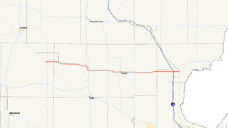
M-78 is a state trunkline highway in the US state of Michigan. The western terminus is the intersection with M-66 north of Battle Creek in Pennfield Township. The roadway runs 10.744 miles (17.291 km) through rural farmland and the community of Bellevue as it approaches its eastern terminus at an interchange with Interstate 69 (I-69) near Olivet. The highway is used by between 3,100 and 5,300 vehicles on a daily basis.

M-86 (Michigan highway) highway in Michigan, United States

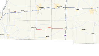
M-86 is an east–west state trunkline highway in the US state of Michigan in the southern portion of the Lower Peninsula. The highway starts at Business US Highway 131 and M-60 in Three Rivers and ends at US Highway 12 (US 12) near Coldwater. In between, it crosses farm country and runs along a section of the Prairie River. Following a highway originally numbered M-7, the roadway was renumbered M-86 in 1940. It has been a part of the state highway system at least since 1927. Two other roadways carried the M-86 designation in the 1920s. Two bridges along the road are eligible for inclusion on the National Register of Historic Places (NRHP).

M-43 (Michigan highway) highway in Michigan, United States

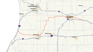
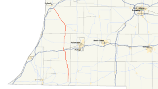
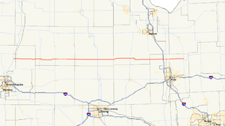
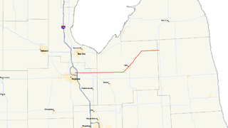
M-43 is a state trunkline highway in southwestern and central parts of the US state of Michigan. The highway runs from South Haven to Webberville along an indirect path through both rural areas and larger cities. The trunkline follows three overall segments: a southeasterly track from South Haven to Kalamazoo, a northeasterly course to the Hastings area and an easterly route through the Lansing area.

M-40 (Michigan highway) highway in Michigan, United States

M-40 is a north–south state trunkline highway in the Lower Peninsula of the US state of Michigan. The highway runs from US Highway 12 (US 12) near the Indiana state line in Porter Township north through Paw Paw and Allegan to end in the outskirts of Holland. The current northern end is near Interstate 196 (I-196) at an intersection with US 31/Business Loop I-196 (BL 196). In between, M-40 runs through mixed agricultural and forest lands and along lakes and rivers through Southwest Michigan.

M-79 (Michigan highway) highway in Michigan, United States

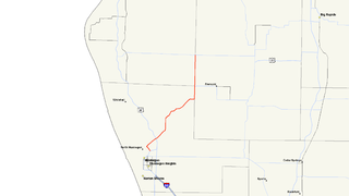
M-79 is an east–west state trunkline highway in the central portion of Lower Peninsula of the U.S. state of Michigan. The western terminus is about three miles (4.8 km) southeast of Hastings at the junction with M-37 and the eastern terminus is in downtown Charlotte at the junction with M-50 and Business Loop Interstate 69 (BL I-69). It passes through Quimby and Nashville, where there is a junction with M-66. The entire highway is undivided surface road. It has no direct access with Interstate 69 (I-69), although a sign for the highway is located on southbound I-69 at exit 61.

M-76 is a former state trunkline highway designation in the Lower Peninsula of the US state of Michigan. The highway's designation was decommissioned when the last section of it was converted to freeway as a part of the present-day Interstate 75 (I-75). At that time, M-76 extended from US Highway 23 (US 23) near Standish northwesterly to I-75 south of Grayling. Two sections of the route followed freeways with a two-lane highway in between to connect them. The former routing of M-76 through West Branch before that city was bypassed was initially redesignated Business M-76. The highway itself ran through mixed fields and forests bypassing several other towns in the region.

C-66 (Michigan county highway) county road in Michigan

C-66 is a county-designated highway in the US state of Michigan running about 28 miles (45 km) across the northern tip of the Lower Peninsula. The roadway starts in the unincorporated community of Cross Village in Emmet County at an intersection with M-119 and C-77. It follows Levering Road through rural areas to an interchange with Interstate 75 (I-75) west of Cheboygan. The eastern terminus is at an intersection with US Highway 23 (US 23) and M-27 in downtown Cheboygan. The first roadways along what is now C-66 were in place by the early 20th century. Segments were paved by 1936, although some reverted to a gravel surface during World War II. The full roadway was paved by the mid-1950s, and the C-66 moniker was designated on the roadway in the early 1970s.

M-17 is a 6.390-mile-long (10.284 km) state trunkline highway in the U.S. state of Michigan, connecting the cities of Ypsilanti and Ann Arbor in Washtenaw County. It was once part of a highway that spanned the southern Lower Peninsula of Michigan before the creation of the U.S. Highway System in 1926. The designation once extended into downtown Detroit, but the eastern terminus was progressively scaled back in the late 1960s to the current location in Ypsilanti. The changes made to the highways in Washtenaw County spawned Business M-17, a business loop for 11 years between 1945 and 1956.

M-120 (Michigan highway) highway in Michigan, United States

M-120 is a state trunkline highway in the US state of Michigan in the southwest Lower Peninsula. The highway runs northeast from Muskegon to Hesperia. In between, the road passes through suburban Muskegon, forests and farmland. Some 5,900–26,000 vehicles use the highway each day on average as it runs long a series of roads that follow county lines in the area.

M-129 (Michigan highway) highway in Michigan, United States

M-129 is a state trunkline highway in the Upper Peninsula (UP) of the US state of Michigan. It runs from Cedarville to Sault Ste. Marie. South of Nine Mile Road in Chippewa County, M-129 overlays the Michigan Meridian. The section of M-129 that overlays the meridian is named Meridian Road. The highway between M-48 and the northern terminus is a part of the larger Lake Huron Circle Tour.

M-91 (Michigan highway) highway in Michigan, United States

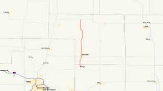
M-91 is a largely north–south state trunkline highway in the Lower Peninsula of the US state of Michigan. It runs from Belding to south of Lakeview. Its 24-mile (39 km) length exists entirely within Ionia and Montcalm counties. It is all undivided surface route. Aside from the two Michigan state highways that are its termini, it has only one other intersection with any Michigan state highway, and that is with M-57 in Greenville.

M-57 (Michigan highway) highway in Michigan, United States

M-57 is an east–west state trunkline highway in the US state of Michigan. The 105.377-mile (169.588 km) highway connects US Highway 131 (US 131) near Rockford on the west end to M-15 near Otisville in the Lower Peninsula. In between, the mostly rural highway passes through farmland and connects several highways and smaller towns together. Three of these highways are freeways: US 131, US 127 and Interstate 75 (I-75). Along the way, between 3,700 and 22,300 vehicles use the highway daily.

M-61 (Michigan highway) highway in Michigan, United States

M-61 is a state trunkline highway in the US state of Michigan that runs between Marion and Standish. The highway runs along the boundary area between Northern Michigan and Central Michigan in the Lower Peninsula. M-61 runs through rural forestland connecting several smaller communities together as it connects M-115, US Highway 127 (US 127), Interstate 75 (I-75) and US 23. Less than 10,000 vehicles a day use various segments of the roadway on average.

M-36 (Michigan highway) highway in Michigan, United States

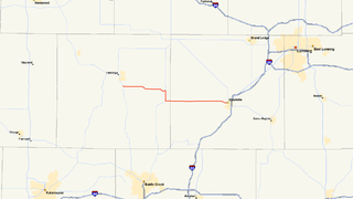
M-36 is a state trunkline highway in the Lower Peninsula of the US state of Michigan that runs in a west–east direction from Mason to Whitmore Lake. The trunkline connects US Highway 127 (US 127) south of Lansing and US 23 north of Ann Arbor. The highway connects several smaller communities in the rural areas along its route. M-36 also runs concurrently with two other roadways, sharing pavement with M-52 and County Road D-19. According to traffic surveys in 2010, between 650 and 15,300 vehicles used the highway on average each day.

M-70 was a state trunkline highway in the US state of Michigan. In the 1920s, the highway originally connected Sterling in southwest Arenac County with Prescott in southeast Ogemaw County. The route was later adjusted to run from M-76 near Sterling along a convoluted route through Maple Ridge and Prescott to end at M-55 in Nester's Corners. The highway was still a gravel road when the designation was removed by 1960.

M-81 (Michigan highway) highway in Michigan, United States

M-81 is an east–west state trunkline highway in the Lower Peninsula of the US state of Michigan. The trunkline travels from the city of Saginaw at the junction with M-13 to the junction with M-53 east of Cass City over the county line in Greenleaf Township in northwestern Sanilac County in The Thumb area of the state. Outside of the cities and villages along its route, M-81 passes through mostly rural farm country. Near Saginaw it intersects the freeway that carries both Interstate 75 (I-75) and US Highway 23 (US 23) in an industrial area.

M-130 (Michigan highway) highway in Michigan, United States

M-130 was the designation of a former state trunkline highway in the southeastern corner of the US state of Michigan. It ran from a junction with US Highway 23/M-50 (US 23/M-50) northward across the River Raisin and then turned southeasterly along North Custer Road on the north side of the river to Monroe. The highway designation was commissioned in 1929 and used until 1955. M-130 had a spur route that was created in 1938 and lasted until the main highway was removed from the state highway system. Both highways are now under local control.

M-132 was the designation of a former state trunkline highway in the Lower Peninsula of the US state of Michigan near Ann Arbor. The highway, commissioned in 1929, connected Ann Arbor and Dexter to the northwest along present-day Dexter–Ann Arbor Road. The roadway was turned back to local control around 1960.

References

  1. 1 2 3 4 Google (February 17, 2008). "Overview Map of Former M-98" (Map). Google Maps . Google. Retrieved February 17, 2008.
  2. 1 2 Michigan State Highway Department (July 1, 1919). State of Michigan (Map). Scale not given. Lansing: Michigan State Highway Department. Upper Peninsula sheet. OCLC   15607244 . Retrieved December 18, 2016 via Michigan State University Libraries.
  3. 1 2 3 Michigan State Highway Department (1960). Official Highway Map (Map). [c. 1:918,720]. Lansing: Michigan State Highway Department. §§ C8–D8. OCLC   12701120, 81552576 . Retrieved August 12, 2017 via Archives of Michigan. (Includes all changes through July 1, 1960)
  4. 1 2 Michigan State Highway Department (1961). Official Highway Map (Map). [c. 1:918,720]. Lansing: Michigan State Highway Department. §§ C8–D8. OCLC   12701120, 51857665 . Retrieved June 17, 2017 via Archives of Michigan. (Includes all changes through July 1, 1961)
  5. "Michigan May Do Well Following Wisconsin's Road Marking System". The Grand Rapids Press . September 20, 1919. p. 10.
  6. Michigan State Highway Department (May 1, 1929). Official Highway Service Map (Map). [c. 1:810,000]. Lansing: Michigan State Highway Department. OCLC   12701195, 79754957.
  7. Michigan State Highway Department & H.M. Gousha (January 1, 1930). Official Highway Service Map (Map). [c. 1:810,000]. Lansing: Michigan State Highway Department. OCLC   12701195, 79754957.
  8. Michigan State Highway Department & H.M. Gousha (July 1, 1930). Official Highway Service Map (Map). [c. 1:810,000]. Lansing: Michigan State Highway Department. OCLC   12701195, 79754957.
  9. Michigan State Highway Department & Rand McNally (June 1, 1936). Official Michigan Highway Map (Map). [c. 1:850,000]. Lansing: Michigan State Highway Department. § C8. OCLC   12701143.
  10. Michigan State Highway Department (July 1, 1949). Michigan Official Highway Map (Map). [c. 1:918,720]. Lansing: Michigan State Highway Department. § D8. OCLC   12701120.
  11. Michigan State Highway Department (April 15, 1950). Michigan Official Highway Map (Map). [c. 1:918,720]. Lansing: Michigan State Highway Department. § D8. OCLC   12701120.
  12. Michigan State Highway Department (October 1, 1957). Official Highway Map (Map). [c. 1:918,720]. Lansing: Michigan State Highway Department. § D8. OCLC   12701120, 367386492.
  13. Michigan State Highway Department (1958). Official Highway Map (Map). [c. 1:918,720]. Lansing: Michigan State Highway Department. § D8. OCLC   12701120, 51856742 . Retrieved December 18, 2016 via Archives of Michigan. (Includes all changes through July 1, 1958)
  14. 1 2 Michigan Department of Transportation (2015). Pure Michigan: State Transportation Map (Map). c. 1:975,000. Lansing: Michigan Department of Transportation. Full map. OCLC   42778335, 900162490.
  15. "County Primary Road Marking System Okayed". The Holland Evening Sentinel . October 5, 1970. p. 6. ISSN   1050-4044. OCLC   13440201 . Retrieved May 17, 2017 via Newspapers.com. Open Access logo PLoS transparent.svg
  16. Michigan Department of State Highways (1971). Michigan, Great Lake State: Official Highway Map (Map). c. 1:918,720. Lansing: Michigan Department of State Highways. §§ C8–D8. OCLC   12701120, 77960415.

Route map: Google

KML file (edithelp)
KML is from Wikidata