North Brabant, also unofficially called Brabant, is a province in the south of the Netherlands. It borders the provinces of South Holland and Gelderland to the north, Limburg to the east, Zeeland to the west, and the Flemish provinces of Antwerp and Limburg to the south. The northern border follows the Meuse westward to its mouth in the Hollands Diep strait, part of the Rhine–Meuse–Scheldt delta. North Brabant has a population of 2,562,566 as of November 2019. Major cities in North Brabant are Eindhoven, Tilburg, Breda and its provincial capital 's-Hertogenbosch.

The Meierij van 's-Hertogenbosch was one of the four parts of the duchy of Brabant, the others being the margraviate of Antwerp, the county of Brussels, and the county of Leuven/Louvain. It got its name from the Bailiff of 's-Hertogenbosch, which administered the area in the name of the Dukes of Brabant. The Meierij roughly corresponds to the somewhat larger Dutch province of North Brabant.

Sint-Oedenrode is a town in the province of North Brabant.

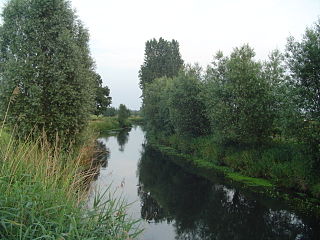
The Dommel is a small river in Belgium and the Netherlands, left tributary of the Dieze. It is 120 km long, of which 85 km in the Netherlands. The Dommel takes in water from the Keersop, Tongelreep, Run, Gender and Kleine Dommel streams and merges at 's-Hertogenbosch with the Aa stream to form the river Dieze, which subsequently flows towards the Meuse. The main cities and towns along the Dommel's course are Peer, Neerpelt, Valkenswaard, Dommelen, Eindhoven, Son en Breugel, Sint-Oedenrode, Boxtel, Sint-Michielsgestel and 's-Hertogenbosch.
Bouches-du-Rhin was a department of the First French Empire in the present-day Netherlands. It was named after the mouth of the river Rhine. It was formed in 1810, when the Kingdom of Holland was annexed by France. Its territory corresponded with the eastern half of the present-day Dutch province of North Brabant and a part of the province of Gelderland. Its capital was 's-Hertogenbosch.
Abruzzo, Lazio and Molise National Park is an Italian national park established in 1923. The majority of the park is located in the Abruzzo region, with smaller parts in Lazio and Molise. It is sometimes called by its former name Abruzzo National Park. The park headquarters are in Pescasseroli in the Province of L'Aquila. The park's area is 496.80 km2 (191.82 sq mi).

Sint-Agatha-Rode, named after the third-century Christian martyr Saint Agatha of Sicily, is a Dutch-speaking village in Belgian province of Flemish Brabant and lies within the district of the town of Huldenberg. Historically Sint-Agatha-Rode was an independent municipality (Gemeente) until the merger of Belgian municipalities in 1977 when it was joined to the town of Huldenberg.

Utrechtse Heuvelrug National Park is a national park in the Dutch province of Utrecht. It covers the southern part of the Utrecht Hill Ridge. When it was founded in 2003, the park covered 6,000 ha of heathlands, shifting sands, forests, grass lands and floodplains. In 2013 the park was extended to 10,000 ha, adding the area north of highway A12 when the ecoduct Mollebos was realized. The most striking landscape feature is the glacial ridge after which the park is named.

The Celtic broadleaf forests are a terrestrial ecoregion that covers most of the islands of Great Britain and Ireland.

Nijnsel is a village in the province of North Brabant, located in the Meierij of 's-Hertogenbosch. Nijnsel is a parish of the municipality of Meierijstad.
The Dommelbeemden are, along with the Moerkuilen a forestry area in a bend of the Dommel river northeast of Nijnsel in Meierijstad. It is located at the Lieshoutse Dijk, not far from the A50 motorway. The protected area measures over 100 acres. The Dommelbeemden are part of the larger area Het Groene Woud.
East of the village of Nijnsel and the hamlet of Vressel, both in Meierijstad, North Brabant, Netherlands, is the location of the Vresselse bossen or Vresselsche Bosch . The Vresselse Bossen is a forest area of 241 ha. It is owned and managed by the National Forest Service (Staatsbosbeheer). The forest is named after the nearby hamlet of Vressel.
The forest and nature area the Geelders is located at the western side of the village of Olland in Meierijstad, North Brabant and covers almost 300 hectares. The Geelders are part of the larger area Het Groene Woud.

Sint-Oedenrode is a moderately urbanized city and capital of the former municipality of the same name in the province of North Brabant. The city is located in the Meierij of 's-Hertogenbosch. Sint-Oedenrode counts 17,928 inhabitants and has an area of 64.25 km². The municipality has traditionally city rights since 1232, and was known as a "Vlek" in the past. Today it is still a large town. From southeast to northwest, the city is split by the river the Dommel.
The forest and nature areas De Rooise Broek and De Scheeken borders on the outskirts of the village of Boskant, Meierijstad, North Brabant. Both De Rooise Broek and De Scheeken are part of the larger area Het Groene Woud.

The wildlife of Sweden includes the diverse flora and fauna of Sweden. Habitats include mountain heath, montane forests, tundra, taiga, beech forests, rivers, lakes, bogs, brackish and marine coasts and cultivated land. The climate is in general very mild for a country at this latitude, because of the significant maritime influence.

The Atlantic mixed forests is a terrestrial ecoregion in western Europe. It extends along the western edge of continental Europe, from southwestern France through northern France, Belgium, the Netherlands, northwestern Germany, and western Denmark. Most of the region's forests and dunes have been converted to fields, pastures, and forest plantations, and its once-extensive wetlands have mostly been drained and filled.

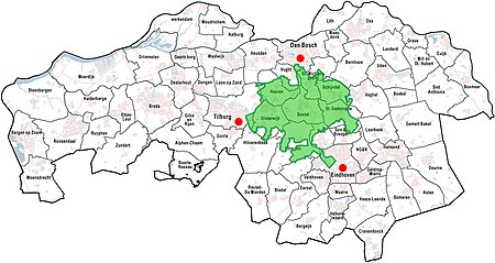
Van Gogh National Park is a proposed Dutch national park, presented on 30 March 2021.

Brabants Landschap, officially Stichting het Noordbrabants Landschap, is one of the 12 provincial landscape foundations in the Netherlands.

Gaizinkalns Nature Park is located in Latvia in Madona Municipality Vestienas, Aronas and Bērzaunes parishes, Natura 2000 territory. The territory of the park covers Vidzeme Uplands around Gaizinkalns, Lake Talejas and Viešūrs, as well as several small lakes. Here is the highest place in Latvia - Gaizinkalns - 311.94 m.