
A glacier is a persistent body of dense ice that is constantly moving under its own weight. A glacier forms where the accumulation of snow exceeds its ablation over many years, often centuries. Glaciers slowly deform and flow under stresses induced by their weight, creating crevasses, seracs, and other distinguishing features. They also abrade rock and debris from their substrate to create landforms such as cirques, moraines, or fjords. Glaciers form only on land and are distinct from the much thinner sea ice and lake ice that forms on the surface of bodies of water.

The Pennine Alps, also known as the Valais Alps, are a mountain range in the western part of the Alps. They are located in Switzerland (Valais) and Italy.

An ice field is a mass of interconnected valley glaciers on a mountain mass with protruding rock ridges or summits. They are often found in the colder climates and higher altitudes of the world where there is sufficient precipitation for them to form. The higher peaks of the underlying mountain rock that protrude through the icefields are known as nunataks. Ice fields are larger than alpine glaciers, but smaller than ice caps and ice sheets. The topography of ice fields is determined by the shape of the surrounding landforms, while ice caps have their own forms overriding underlying shapes.
Great Glacier Provincial Park is a provincial park located in the Stikine Country region of British Columbia, Canada. It was established on January 25, 2001 to protect Great Glacier and the surrounding mountainous terrain. The park lies in the traditional territory of the Tahltan First Nation about 120 kilometres (75 mi) south of the Tahltan community of Telegraph Creek.

The Athabasca Glacier is one of the six principal 'toes' of the Columbia Icefield, located in the Canadian Rockies. The glacier currently loses depth at a rate of about 5 metres (16 ft) per year and has receded more than 1.5 km (0.93 mi) and lost over half of its volume in the past 125 years. Easily accessible, it is the most visited glacier in North America. The leading edge of the glacier is within easy walking distance; however, travel onto the glacier is not recommended unless properly equipped. Hidden crevasses have led to the deaths of unprepared tourists.
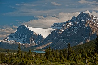
Bow Glacier is located in Banff National Park, Alberta, Canada, approximately 37 km (23 mi) northwest of Lake Louise. It can be viewed from the Icefields Parkway. Bow Glacier is an outflow glacier from the Wapta Icefield, which rests along the Continental Divide, and runoff from the glacier supplies water to Bow Lake and the Bow River. The glacier is credited for creating the Bow Valley before retreating at the end of the last glacial maximum.
Vulture Glacier is located in Banff National Park, Alberta, Canada, northwest of Lake Louise, and can be viewed from the Icefields Parkway. Vulture Glacier is an outflow glacier from the Wapta Icefield, which rests along the Continental Divide. The glacier had an area of 4.9 km2 (1.9 mi2) in the 1980s, however, all of the glaciers in the Canadian Rockies have been retreating steadily since the middle of the 19th century.
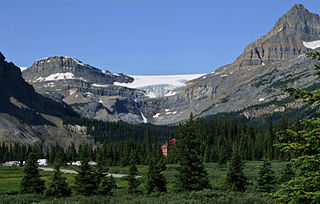
Crowfoot Glacier is located in Banff National Park, Alberta, Canada, 32 km (20 mi) northwest of Lake Louise, and can be viewed from the Icefields Parkway. The glacier is situated on the northeastern flank of Crowfoot Mountain.

The Waputik Icefield is located on the Continental divide in the Canadian Rocky Mountains, in the provinces of British Columbia and Alberta. It is developed on the heights of the Waputik Range in the Central Main Ranges.

The Wapta Icefield is located on the Continental Divide in the Waputik Mountains of the Canadian Rockies, in the provinces of British Columbia and Alberta. The icefield is shared by Banff and Yoho National Parks and numerous outlet glaciers extend from the icefield, including the Vulture, Bow and Peyto Glaciers. Runoff from the icefields and outlet glaciers supply water to both the Kicking Horse and Bow Rivers, as well as numerous streams and lakes.

The sub-Antarctic zone is a region in the Southern Hemisphere, located immediately north of the Antarctic region. This translates roughly to a latitude of between 46° and 60° south of the Equator. The subantarctic region includes many islands in the southern parts of the Atlantic, Indian, and Pacific oceans, especially those situated north of the Antarctic Convergence. Sub-Antarctic glaciers are, by definition, located on islands within the sub-Antarctic region. All glaciers located on the continent of Antarctica are by definition considered to be Antarctic glaciers.
Crescent Glacier is a small alpine glacier in Antarctica. It is located just east of Howard Glacier in the Kukri Hills, flowing north into Taylor Valley in Victoria Land. The glacier was studied by U.S. geologist Troy L. Pewe in December 1957, and was so named by him because of its crescent shape when viewed from the floor of Taylor Valley.
Kluane / Wrangell–St. Elias / Glacier Bay / Tatshenshini-Alsek is an international park system located in Canada and the United States, at the border of Yukon, Alaska and British Columbia.
Falkner Glacier, is an east-flowing valley glacier, 4 nautical miles long, located 2 nautical miles south of Oakley Glacier in the Mountaineer Range, Victoria Land, Antarctica. The glacier descends steeply to Lady Newnes Bay where it forms a floating glacier tongue. It was named by the Advisory Committee on Antarctic Names (2008) after Kelly K. Falkner, Professor of Chemical Oceanography at Oregon State University, who served from 2006 as the first Program Director for the Antarctic Integrated System Science Program in the Division of Antarctic Sciences, Office of Antarctic Programs, National Science Foundation.

Narechen Glacier is the 9 km long and 11 km wide glacier draining the western slopes of the Lassus Mountains on the northwest coast of Alexander Island in Antarctica. Flowing westwards to enter Lazarev Bay in the Wilkins Sound, Bellingshausen Sea. The glacier is situated south of the southwestern ridge of Mount Wilbye and north of Faulkner Nunatak.
Iliev Glacier is the 5 km long and 1.5 km wide glacier located within the Lassus Mountains, situated in the northern portion of Alexander Island, Antarctica. It drains the northwest slopes of Mount Wilbye, the east slopes of Vittoria Buttress and the west slopes of Galerius Peak to flow into Lazarev Bay just south of the terminus of Palestrina Glacier.

Rhesus Glacier is a 7 km long and 2.5 km wide glacier draining the east slopes of the Trojan Range on Anvers Island in the Palmer Archipelago, Antarctica southeast of Paris Peak. Situated east of Iliad Glacier, south of Lipen Glacier and north of Thamyris Glacier. Flowing northeastwards into Fournier Bay south of Thompson Peninsula and north of Predel Point.
Ball Glacier is a glacier 7 nautical miles (13 km) long with the head located between Mount Lister and Mount Hooker on the east side of the Royal Society Range. The glacier flows northeast between Craw Ridge and Tasman Ridge into Blue Glacier. It was named by the New Zealand Geographic Board after Gary Ball, a New Zealand mountaineer who climbed Mount Lister with an Italian field party, 1976–77, and camped on this glacier; he was field assistant with R.H. Findlay's New Zealand Antarctic Research Program party to this area, 1980–81.

Allison Glacier is a small glacier in Victoria Land, Antarctica. Its head is located just north of Mount Huggins, descending from the west slopes of Royal Society Range into Skelton Glacier. Abbott Spur separates the lower ends of Rutgers Glacier from Allison Glacier.
