
High Force is a waterfall on the River Tees, near Middleton-in-Teesdale, Teesdale, England. The waterfall is within the North Pennines Area of Outstanding Natural Beauty (AONB) and the European Geopark. The whole of the River Tees plunges 70 feet (21 m) over a precipice in two stages. After heavy rainfall the river will also flow over the usually dry right-hand side channel, creating two falls. Very occasionally the river level will be high enough to flow over the central section of rock; the last recorded time this happened was in December 2015 after Storm Desmond. In harsh winters the falls have been known to freeze, creating cathedral-like ice formations.

The Pennine Way is a National Trail in England, with a small section in Scotland. The trail stretches for 268 miles (431 km) from Edale, in the northern Derbyshire Peak District, north through the Yorkshire Dales and Northumberland National Park and ends at Kirk Yetholm, just inside the Scottish border. The path runs along the Pennine hills, sometimes described as the "backbone of England". Although not the United Kingdom's longest National Trail, it is, according to The Ramblers, "one of Britain's best known and toughest".
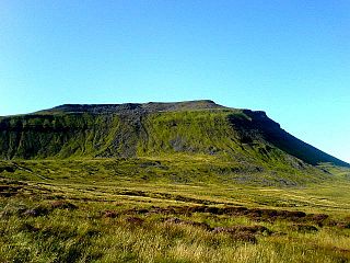
The mountains of Whernside, Ingleborough and Pen-y-ghent are collectively known as the Three Peaks. The peaks, which form part of the Pennine range, encircle the head of the valley of the River Ribble in the Yorkshire Dales National Park in the North of England.

The Old Man of Coniston is a fell in the Furness Fells of the Lake District in Cumbria, England, and is the highest point of the historic county of Lancashire. It is at least 2,632.62 feet (802.42 m) high, and lies to the west of the village of Coniston and the lake, Coniston Water. The fell is sometimes known by the alternative name of Coniston Old Man, or simply The Old Man. The mountain is popular with tourists and fell-walkers with a number of well-marked paths to the summit. The mountain has also seen extensive copper and slate mining activity for eight hundred years, and the remains of abandoned mines and spoil tips are a significant feature of the north-east slopes.

Bowfell is a pyramid-shaped mountain lying at the heart of the English Lake District, in the Southern Fells area. It is the sixth-highest mountain in the Lake District and one of the most popular of the Lake District fells for walkers. It is listed in Alfred Wainwright's 'best half dozen' Lake District fells.

The North Pennines is the northernmost section of the Pennine range of hills which runs north–south through northern England. It lies between Carlisle to the west and Darlington to the east, straddling the borders of the counties of Cumbria, Durham, Northumberland and North Yorkshire. It is bounded to the north by the Tyne Valley and to the south by the Stainmore Gap.

Teesdale is a dale, or valley, located principally in County Durham, North East England. It is one of the Durham Dales, which are themselves part of the North Pennines, the northernmost part of the Pennine uplands.

Great Dodd is a mountain or fell in the English Lake District. It stands on the main ridge of the Helvellyn range, a line of mountains which runs in a north–south direction between the lakes of Thirlmere and Ullswater in the east of the Lake District. Great Dodd, with a height of 857 metres (2,812 ft) is the highest of the fells in this range to the north of Sticks Pass.
Crag Hill is a mountain in the North Western part of the English Lake District. It was formerly known as Eel Crag; however, the Ordnance Survey now marks Eel Crag as referring to the northern crags of the fell. It is not to be confused with another Crag Hill lying on the border of North Yorkshire.

Kirk Fell is a fell in the Western part of the English Lake District. It is situated between Great Gable and Pillar on the long ring of fells surrounding the valley of Ennerdale, and also stands over Wasdale to the south. However, it is separated from its two higher neighbours by the low passes of Black Sail and Beck Head, giving it a high relative height and making it a Marilyn, the thirteenth highest in the Lake District.

Castle Crag is a hill in the North Western Fells of the English Lake District. It is the smallest hill included in Alfred Wainwright's influential Pictorial Guide to the Lakeland Fells, the only Wainwright below 1,000 feet (300 m).

The Whin Sill or Great Whin Sill is a tabular layer of the igneous rock dolerite in County Durham, Northumberland and Cumbria in the northeast of England. It lies partly in the North Pennines Area of Outstanding Natural Beauty and partly in Northumberland National Park and stretches from Teesdale northwards towards Berwick.

Hopegill Head is a fell in the English Lake District in Cumbria. It is located nine kilometres west of the town of Keswick and is well seen from the B5292 road which crosses the Whinlatter Pass.

Baugh Fell is a large, flat-topped hill in the northern Pennines of England. It lies in the north-western corner of the Yorkshire Dales National Park, immediately to the east of the Howgill Fells and to the north of Whernside, the highest of the Yorkshire Three Peaks. Formerly in the West Riding of Yorkshire, since 1974 it has been part of the county of Cumbria.
A gill or ghyll is a ravine or narrow valley in the North of England and parts of Scotland. The word originates from the Old Norse gil. Examples include Dufton Ghyll Wood, Dungeon Ghyll, Troller's Gill and Trow Ghyll. As a related usage, Gaping Gill is the name of a cave, not the associated stream, and Cowgill, Masongill and Halton Gill are derived names of villages.

Keisley is a small hamlet in the English county of Cumbria. It is located in the Dufton civil parish and the Eden district.
The geology of County Durham in northeast England consists of a basement of Lower Palaeozoic rocks overlain by a varying thickness of Carboniferous and Permo-Triassic sedimentary rocks which dip generally eastwards towards the North Sea. These have been intruded by a pluton, sills and dykes at various times from the Devonian Period to the Palaeogene. The whole is overlain by a suite of unconsolidated deposits of Quaternary age arising from glaciation and from other processes operating during the post-glacial period to the present. The geological interest of the west of the county was recognised by the designation in 2003 of the North Pennines Area of Outstanding Natural Beauty as a European Geopark.
The geology of the Yorkshire Dales National Park in northern England largely consists of a sequence of sedimentary rocks of Ordovician to Permian age. The core area of the Yorkshire Dales is formed from a layer-cake of limestones, sandstones and mudstones laid down during the Carboniferous period. It is noted for its karst landscape which includes extensive areas of limestone pavement and large numbers of caves including Britain's longest cave network.

