High Street, Lincoln

Last updated

High Street
Lincoln-high-street-level-crossing.redvers.jpg
Two main railway lines used to cross the High Street.
St Marks has gone, leaving this one at Lincoln Central
Former name(s) Ermine Street, Iter VI of the Antonine Itinerary
Maintained by Lincolnshire County Council
Length1.9 km (1.2 mi) [1]
Addresses1–480
Location Lincoln, England
Postal codeLN5 7DW
Coordinates 53°13′36″N0°32′29″W / 53.226797°N 0.541486°W / 53.226797; -0.541486 (High Street, Lincoln)
Northern endThe Strait, Motherby Lane
53°13′53″N0°32′22″W / 53.231465°N 0.539499°W / 53.231465; -0.539499 (High Street, Lincoln (Northern end))
Major
junctions
Clasketgate, Mint Street, Saltergate, St Mary's Street, Railway Line
Southern endSt Catherine Roundabout (A1434)
53°12′53″N0°32′46″W / 53.214602°N 0.546228°W / 53.214602; -0.546228 (High Street, Lincoln (Southern end))
Construction
CommissionedRoman

High Street in Lincoln, England extends from the St Catherine's roundabout and ends approximately 1.2 miles further north at The Strait. The historic High Street has evolved through many changes over its 2000 year history, encompassing Roman roads and settlement, medieval buildings, markets, places of worship, civic buildings, bridges, the arrival of the railways and heavy industry.

Contents

The greatest concentration of listed buildings is north of the railway station in the pedestrianised area where most of the city's commercial, retail and cultural areas are located. South of the railway station there are fewer listed buildings the street is a busy urban road numbered the B1262.

History

High Street in Lincoln follows the route of Ermine Street, a major Roman road that linked London (Londinium) to Lincoln (Lindum Colonia) and onwards to the Humber. [2] Ermine Street was built between 60 and 90 AD. It was joined south of Lincoln by the Fosse Way. The Roman road passed through low-lying wetland by the River Witham on a causeway. The river flowed north to Brayford Pool, parallel to the west of the street, before turning east to be crossed at an important crossing, now the medieval High Bridge. In Roman times the river was much wider and was important for trade. [3]

The city declined after the Romans left but the High Street kept roughly to the Roman line and developed between 1000 and 1300 AD when it was built on both sides as far as Wigford. Streets including Garmston Street, Silver Street, Swan Street and Flaxengate were developed at this time and land behind the houses on both sides of High Street was divided into long narrow burgage plots. From the 11th century Wigford developed as a suburb for "substantial elite residences" with six parish churches, of which two survive, and stretched from High Bridge to the Sincil Dyke. [3]

In the 16th and 17th centuries new houses and commercial properties were built with timber frames including those on High Bridge. The markets moved south from the slope onto High Street. [3] During the Industrial Revolution, heavy industry attracted a growth in population. Inns and hotels were built for visitors and locals and places of worship were built for non-conformists. [3] The railway arrived in 1846 when the Midland Railway opened Lincoln Station. [3] It was renamed Lincoln St Marks in 1950, closed in 1985, and redeveloped as a shopping centre. It was followed by the Great Northern in 1848. [4]

The character of High Street, the main retail spine of the city, changes from small independent shops to national retailers further down the hill. A clear change occurs after it passes the railway level crossing at St Mary’s Street and leaves the city centre. Here, on the flat area, large scale development took place during the industrial revolution, streets of terraced housing for workers join at right angles, giving the southern part of High Street a different character. [5] In 2021 the city council and English Heritage funded a Heritage Action Zone to run up to 2024 for parts of the lower High Street with the aim of revitalising an area that had become tired and run down. It involved restoring heritage buildings and renewing shop fronts to future proof them, attract more businesses and showcase its interesting history. [6]

Landmarks and listed buildings

Looking to the north, High Street is dominated by Lincoln Cathedral, which is prominently placed in "Uphill" Lincoln. While today that area is noted for the castle and many fine medieval and later buildings, the High Street in "Downhill" has many important buildings scattered in amongst the more recent shopping developments. During the construction of the former Boots the Chemist on the eastern side of the High Street at its junction with Clasketgate in 1924, the remains of a Roman building, now a scheduled monument, were uncovered including a hypocaust, which is on display in the basement. [7] More than 30 listed buildings are adjacent to or face onto the High Street. [8] The Guildhall and Stonebow, St Mary le Wigford and St Mary's Guildhall are Grade I listed buildings. The St Peter at Gowt's conservation area, towards the southern end of High Street, was designated in 1975. [9]

The Stonebow and Guildhall is Lincoln's town gate with a guildhall above, dating from the 15th century and restored in 1885-87. The figures in the niches are (left) the Archangel Gabriel and (right) the Virgin Mary, patron saint of the city and cathedral. [10] In the centre is the royal coat of arms of James I, dated 1605. It replaced an earlier gate, possibly Norman, but conceivably the south gate of the Roman city.

St Mary le Wigford Church is next to the railway crossing signalbox. [11] Further south is St Peter at Gowts, an 11th century church built by the Great Gowt Drain. [12] Close to it is St Mary's Guildhall, once known as John o'Gaunt's Stables. Built around 1157, it was possibly the town house of Henry II. It was used as a guildhall for nearly three hundred years until 1547. In the early 17th century it was used as a school and part was let out for maltings. It was restored between 1984 and 1986 and houses the Lincoln Civic Trust and St Peter at Gout's church hall. [13] [14] At the southern end of the street is St Botolph's Church, the oldest part is its west tower of 1721. [15]

Two contrasting places of worship, almost opposite each other on the lower High Street are the plain Unitarian Chapel of 1725, [16] and the more flamboyant Central Methodist Church of 1905. [17]

Paintings

Historic paintings and drawings give a good idea how buildings and the streetscapes have changed over the years. Two paintings in Lincoln's Usher Gallery demonstrate the changes that have taken place. Both paintings were made from approximately the same position, close to the Church of St Mary le Wigford. The earliest, which may date from around 1800 by Henry Hall, shows the cobbled streets lined with buildings of the Georgian period, most of which have now disappeared. In the distance is the obelisk shaped water conduit that was placed on the High Bridge over the River Witham to supply the street with water. Beyond this and below the cathedral is the tower of St Peter at Arches, which was demolished in 1932 to make way for new shops. Some fifty years later the sporting artist John E. Ferneley I shows the change brought about by the coming of the railway, with a level crossing cutting across the street. Many Georgian buildings are still there and the lower water conduit at St Mary le Wigford is shown on the right.

Another watercolour view of the High Street around 1820 is by the artist and architect Ambrose Poynter. This is viewed from the south end of the street, fairly close to the Great Bargate (demolished ic.1759) [18] This watercolour is viewed from the south end of the street, looking north towards Lincoln Cathedral. It appears to show St Peter at Gowt's Church on the right hand side and the Little Gowt Drain that crossed the High Street just below the church. The other buildings shown all appear to have been demolished.

Numbering

The numbering of premises is consecutive, which is unusual compared with most of the country. Number 1, High Street, starts with the first building on the western side at the southern end of the street, the neighbouring property is Number 2, followed by Number 3 and so on. This pattern continues northwards, uphill until the High Street meets The Strait. The sequential numbering system then continues southward, down the High Street on the eastern side, until reaching Number 471-480, opposite number 1.

See also

Related Research Articles

<span class="mw-page-title-main">Lincoln, England</span> Cathedral city in Lincolnshire, England

Lincoln is a cathedral city and district in Lincolnshire, England, of which it is the county town. In the 2021 Census, the Lincoln district had a population of 103,813. The 2011 census gave the urban area of Lincoln, including North Hykeham and Waddington, a population of 115,000, a figure which has been updated to 127,540 with the 2021 census.

<span class="mw-page-title-main">Stamford, Lincolnshire</span> Town in Lincolnshire, England

Stamford is a town and civil parish in the South Kesteven District of Lincolnshire, England. The population at the 2011 census was 19,701 and estimated at 20,645 in 2019. The town has 17th- and 18th-century stone buildings, older timber-framed buildings and five medieval parish churches. It is a frequent film location. In 2013 it was rated a top place to live in a survey by The Sunday Times. Its name has been passed on to Stamford, Connecticut, founded in 1641.

<span class="mw-page-title-main">Ancaster, Lincolnshire</span> Village in the South Kesteven district of Lincolnshire, England

Ancaster is a village and civil parish in the South Kesteven district of Lincolnshire, England, on the site of a Roman town. The population of the civil parish was 1,317 at the 2001 census increasing to 1,647 at the 2011 census. The civil parish includes the settlements of Sudbrook and West Willoughby.

Broughton is a small town and civil parish situated on the Roman Ermine Street, in the North Lincolnshire district of Lincolnshire, England. The population of the civil parish at the 2011 census was 5,726. In 2021, the population was 5,434. It is situated approximately 2 miles (3 km) north-west from the town of Brigg. The hamlets of Wressle, Castlethorpe, and part of Scawby Brook lie within the parish boundaries.

<span class="mw-page-title-main">Caythorpe, Lincolnshire</span> Large village and civil parish in the South Kesteven district of Lincolnshire, England

Caythorpe is a large village and civil parish in the South Kesteven district of Lincolnshire, England. The population at 2011 census was 1,374. It is situated on the A607, approximately 3 miles (5 km) south from Leadenham and 9 miles (14 km) north from Grantham. Caythorpe Heath stretches east of the village to Ermine Street and Byards Leap.

<span class="mw-page-title-main">Navenby</span> Village and civil parish in Lincolnshire, England

Navenby is a village and civil parish in the North Kesteven district of Lincolnshire, England. Lying 8 miles (13 km) south from Lincoln and 9 miles (14 km) north-northwest from Sleaford, Navenby had a population of 2,128 in the 2011 census and in March 2011, it was named as the 'Best Value Village' in England following a national survey.

<span class="mw-page-title-main">C. Hodgson Fowler</span>

Charles Hodgson Fowler was a prolific English ecclesiastical architect who specialised in building and, especially, restoring churches.

<span class="mw-page-title-main">Sam Scorer</span> British architect (1923-2003)

Hugh Segar "Sam" Scorer FRIBA FRSA was an English architect who worked in Lincoln, England and was a leading pioneer in the development of hyperbolic paraboloid roof structures using concrete. He also was involved in architectural conservation and research into the work of local 19th-century architects, as well as founding an art gallery in Lincoln, now known as the Sam Scorer Gallery. He held the rare distinction of having two of his buildings listed within his lifetime.

<span class="mw-page-title-main">William Adams Nicholson</span> English architect

William Adams Nicholson (1803–1853) was an English architect who worked in Lincoln and was a founding member of the Royal Institute of British Architects.

<span class="mw-page-title-main">St Mary le Wigford</span> Church in United Kingdom

St Mary le Wigford is a Grade I listed parish church in Lincoln, England.

<span class="mw-page-title-main">St Peter at Gowts</span> Church in United Kingdom

St Peter at Gowts is a Grade I listed parish church in Lincoln, Lincolnshire, England.

<span class="mw-page-title-main">John of Gaunt's Palace, Lincoln</span> Historic site in Lincoln

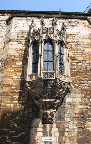
John of Gaunt's Palace was a late 14th-century merchant's house which stood in the lower part of Lincoln High Street, opposite the St Mary Guildhall. It was progressively demolished from the late 18th century until the 1960s. The very fine oriel window from the building has been preserved in the gatehouse of Lincoln Castle.

<span class="mw-page-title-main">Guildhall and Stonebow, Lincoln</span> Municipal building in Lincoln, Lincolnshire, England

The Guildhall and Stonebow, Lincoln, has been the meeting place of Lincoln City Council from Medieval times to the present. The term Stonebow, which is derived from the Danish word stennibogi, indicates a stone archway that visitors entering the city from the south, along the High Street, would have passed through. It is a Grade I listed building. Lincoln City Hall, a 20th-century building on Orchard Street, provides further accommodation for the city council.

<span class="mw-page-title-main">St Peter at Arches Church, Lincoln</span> Church in Lincolnshire, England

St Peter at Arches, Church, Lincoln was an ancient church in Lincoln, England, that was demolished and re-built c. 1720–24 by either Francis or William Smith of Warwick. The church was sited just to the north of the junction of the High Street and Silver Street and close to the Guildhall and Stonebow, Lincoln.

<span class="mw-page-title-main">William Hayward (architect)</span>

William Haywood was an architect who worked in Lincoln, England. His father John who died in 1817 was mayor of Lincoln twice and worked as a mason. Haywood succeeded his father as mayor after his death in 1817. His grandfather, John Hayward (1708–78) was also a mason in Lincoln. William Hayward's great grandfather was Abraham Haywood an architect of Whitchurch, Shropshire who came to Lincoln around 1720. William Haywood succeeded William Lumby as Surveyor to Lincoln Cathedral in 1799 and Edward James Willson followed him in this position in 1823. William Hayward also succeeded William Lumby as Surveyor for the Lincolnshire County County Committee, which had responsibility for Lincoln Castle and the prison. Howard Colvin considered Hayward to be a competent designer in the ‘Regency’ style and that from the re-construction of Kirton in Holland church in 1804 had an understanding of Gothic architecture quite remarkable at that date. Hayward also rebuilt the tower of Wrangle church in a similar style in 1820.

<span class="mw-page-title-main">St Mary's Guildhall, Lincoln</span> Historic site in Lincoln

St Mary's Guildhall is a major domestic complex, indicating the highest social status, built in the part of the medieval city of Lincoln, England, known as Wigford. The Guildhall faces directly onto Lincoln High Street and stands to the north of Sibthorp Street. To the south is the late Saxon church of St Peter at Gowts. Stocker describes it as "the only survivor from the small group of the king's town houses which existed in several major towns….St Mary's Guildhall is a domestic complex on a palatial scale, indicating the highest social status, and as such is representative of a little known urban building type".

<span class="mw-page-title-main">St Benedict's Church, Lincoln</span> Church in Lincolnshire, England

St. Benedict's Church, Lincoln is an ancient church in Lincoln, England which is mentioned in 1107 and before the English Civil War was the Lincoln Civic Church. It was extensively destroyed in the Civil War, and was only partially restored. The tower was re-built imitating the other late Saxon towers in Lincoln. All that survives is the present nave, which was the chancel of the former church' and the chapel to the north built by Robert Tattershall in 1378.

<span class="mw-page-title-main">Timeline of Lincoln</span>

The following is a timeline of the history of the city of Lincoln, the county town of Lincolnshire in the East Midlands of England.

<span class="mw-page-title-main">Central Methodist Church, Lincoln</span> Church in Lincolnshire, England

Central Methodist Church, Lincoln is a Grade II listed Methodist church in the city of Lincoln in Lincolnshire, England. It is an active place of worship in the Boultham area of the city near St Peter at Gowts church. It is one of the most unique listed buildings in Lincoln.
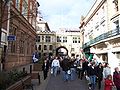
<span class="mw-page-title-main">Lincoln City Centre</span> Central business district in England

Lincoln City Centre is the central business district of Lincoln in Lincolnshire, England. It is defined as the areas along directly north of city's High Street. Each part of the centre brings a differing main sector or sectors to the city with a small overlap between each area.

References

  1. "Google maps walking route" . Retrieved 17 February 2011.
  2. "Monument record MLI70018 – Ermine Street in Lincoln". Lincolnshire Heritage Explorer. Lincolnshire Heritage Explorer. Retrieved 28 July 2023.
  3. 1 2 3 4 5 "Lincoln High Street Character Appraisal Appendix" (PDF). City of Lincoln Council. City of Lincoln Council. November 2018. pp. 9–20. Retrieved 28 July 2023.
  4. Catford, Nick (6 November 2006). "Lincoln St Marks". Disused Stations. Retrieved 28 July 2023.
  5. "Brayford-Masterplan-Design-Access-Statement" (PDF). City of Lincoln Council. Lincoln University. 2016. p. 18. Retrieved 30 July 2023.
  6. "High Street Heritage Action Zone". City of Lincoln Council. City of Lincoln Council. Retrieved 1 August 2023.
  7. "Antram" (1989), p. 520
  8. "Listed Buildings in Lincolnshire". British Listed Buildings. Retrieved 29 July 2023.
  9. "Conservation Area: St Peter at Gowts (Lincoln No.2) (DLI10550)". Lincolnshire Heritage Explorer. Lincolnshire Heritage Explorer. Retrieved 30 July 2023.
  10. Historic England. "Stonebow and Guildhall (1388605)". National Heritage List for England . Retrieved 29 July 2023.
  11. Historic England. "Church of St Mary le Wigford (1388597)". National Heritage List for England . Retrieved 29 July 2023.
  12. Historic England. "Church of St Peter at Gowts (1388599)". National Heritage List for England . Retrieved 29 July 2023.
  13. Historic England. "St Mary's Guildhall (1388604)". National Heritage List for England . Retrieved 29 July 2023.
  14. Historic England. "St Mary's Guild Hall (John O'Gaunt's Stables) (1005035)". National Heritage List for England . Retrieved 29 July 2023.
  15. Historic England. "Church of St Boltoph (1388596)". National Heritage List for England . Retrieved 29 July 2023.
  16. Historic England. "Unitarian Chapel (1388606)". National Heritage List for England . Retrieved 1 August 2023.
  17. Historic England. "Central Methodist Church (1388595)". National Heritage List for England . Retrieved 1 August 2023.
  18. Hill, J. F. W., (1948), Medieval Lincol, C.U.P. Pl 14

Literature

Map all coordinates using: OpenStreetMap

Commons-logo.svg Media related to High Street, Lincoln, England at Wikimedia Commons