
Newlyn is a seaside town and fishing port in south-west Cornwall, UK.

St Day is a civil parish and village in Cornwall, England, United Kingdom. It is situated between the village of Chacewater and the town of Redruth. The electoral ward St Day and Lanner had a population at the 2011 census of 4,473.

St Mawgan or St Mawgan in Pydar is a village and civil parish in Cornwall, England, United Kingdom. The population of this parish at the 2011 census was 1,307. The village is situated four miles northeast of Newquay, and the parish also includes the hamlet of Mawgan Porth. The nearby Royal Air Force station, RAF St. Mawgan, takes its name from the village and is next to Newquay Cornwall Airport. The River Menalhyl runs through St Mawgan village and the valley is known as The Vale of Lanherne. It was the subject of a poem by poet Henry Sewell Stokes.

Lanherne is an historic manor in the parish of St Mawgan in Pydar, in Cornwall, England. The village of St Mawgan is situated four miles northeast of Newquay. It was long a seat of a branch of the prominent Arundell family. The surviving manor house known as Lanherne House is an early 16th-century grade I listed building.
St Columb Canal sometimes referred to as Edyvean's Canal, was an abortive canal scheme in Cornwall, England, designed for the carriage of sea sand for use as manure. It was authorised in 1773, and part of it may have been briefly used around 1780.
Colan is a village and civil parish in mid-Cornwall, England, United Kingdom. It is situated approximately three miles (5 km) east of Newquay. The electoral ward is called Colan and Mawgan. The population of this ward at the 2011 census was 4,256 The hamlets of Bosoughan, Chapel, Gwills, Kestle Mill, Lane, Mountjoy, Quintrell Downs, Trebarber and Trencreek are in the parish. Fir Hill Woods near Nanswhyden, contains the ruins of Fir Hill Manor. Colan Church dates to the thirteenth century.

St Martin-in-Meneage is a civil parish and village in the Meneage district of the Lizard Peninsula in Cornwall, England, United Kingdom.

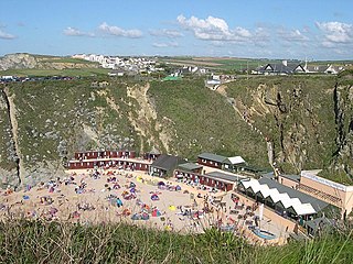
Mawgan Porth is a beach and small settlement in north Cornwall, England. It is situated north of Watergate Bay approximately four miles (6 km) north of Newquay, on the Atlantic Ocean coast.

Bishop's Quay is a hamlet in south-west Cornwall, England, United Kingdom. It is in the civil parish of St. Martin-in-Meneage. It is situated on the south bank of the tidal Mawgan Creek at its confluence with the Helford River five miles (8 km) east of Helston. The Cornish Seal Sanctuary at Gweek is half-a-mile away on the north bank of the Helford River.
Cross Lanes is a hamlet in the parish of Cury, Cornwall, England, UK. According to the Post Office the population at the 2011 census fell in the civil parish of Mawgan-in-Meneage.

Degibna is a hamlet in the parish of Helston, Cornwall, England, UK. It lies on the eastern bank of the largest natural freshwater lake in Cornwall, The Loe, and forms part of the Penrose Estate.

Carloggas is a hamlet in the parish of Mawgan-in-Pydar, Cornwall, England.

Garras is a village in the parish of Mawgan-in-Meneage, in west Cornwall, England, UK.

Mellangoose is a hamlet in the parish of Mawgan-in-Meneage, Cornwall, England.

Tolcarne is the name of a number of places in Cornwall, United Kingdom. The name Tolcarne is derived from Cornish Talkarn i.e. "hill-brow tor". A carn is a pile of stones and is the same as tor in Devon.

Tolcarne Wartha is a hamlet in west Cornwall, England, United Kingdom. It is between Porkellis and Four Lanes near the hill of Carnmenellis.

Trebarber or Trebarver is a hamlet situated off the A3059, just south of RAF St Mawgan in Cornwall, England, United Kingdom.

Tregear is a hamlet near Garras in the parish of Mawgan in Meneage, Cornwall, England, United Kingdom. It should be distinguished from Tregear in the parish of Gerrans.

Trenoon is a farm and former medieval settlement in the parish of Grade-Ruan, Cornwall, England, UK. It is on the edge of Goonhilly Downs.
