Hirschbach, Bavaria

Last updated
Hirschbach
2016 Hirschbach 01.jpg
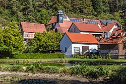
Center of Hirschbach with the chapel
Flagge hirschbach.png
DEU Hirschbach (Oberpfalz) COA.svg
Location of Hirschbach within Amberg-Sulzbach district
Hirschbach in AS.svgKönigsteinHirschbachKastlEichen (unincorporated area)FreudenbergEnsdorfRiedenHohenburg
Germany adm location map.svg
Red pog.svg
Hirschbach
Bavaria location map.svg
Red pog.svg
Hirschbach
Coordinates: 49°33′N11°32′E / 49.550°N 11.533°E / 49.550; 11.533
Country Germany
State Bavaria
Admin. region Oberpfalz
District Amberg-Sulzbach
Municipal assoc. Königstein (Bayern)
Government
   Mayor (202026) Hermann Mertel [1]
Area
  Total
26.76 km2 (10.33 sq mi)
Elevation
390 m (1,280 ft)
Population
 (2023-12-31) [2]
  Total
1,183
  Density44/km2 (110/sq mi)
Time zone UTC+01:00 (CET)
  Summer (DST) UTC+02:00 (CEST)
Postal codes
92275
Dialling codes 09665
Vehicle registration AS
Website www.gemeinde-hirschbach.de

Hirschbach is a municipality in the district of Amberg-Sulzbach in Bavaria in Germany.

Contents

Geography

Apart from Hirschbach the municipality consists of the following villages: [3]

Prototype grandstand in Achtel

The small village of Achtel in Hirschbach is the site of a disused sports grandstand constructed as a prototype for part of the planned Deutsches Stadion in Nuremberg, which Hitler had planned as to be used as a venue for all Olympic Games subsequent to a Nazi victory in World War II. It is now in a state of disrepair. [4]

Notable people

References

  1. Liste der ersten Bürgermeister/Oberbürgermeister in kreisangehörigen Gemeinden, Bayerisches Landesamt für Statistik, 15 July 2021.
  2. Genesis Online-Datenbank des Bayerischen Landesamtes für Statistik Tabelle 12411-003r Fortschreibung des Bevölkerungsstandes: Gemeinden, Stichtag (Einwohnerzahlen auf Grundlage des Zensus 2011).
  3. "Ortsteile mit Postleitzahl" . Retrieved 2024-02-15.
  4. Sebald, Katja. "Hitler's Secret Grandstand: The Nazi Plan to Build World's Biggest Stadium". Der Spiegel. Retrieved 2012-10-18.