Hirschau

Last updated • 1 min readFrom Wikipedia, The Free Encyclopedia
Hirschau
Hirschau 01.jpg
Hirschau seen from Monte Kaolino
DEU Hirschau Banner.svg
DEU Hirschau COA.svg
Location of Hirschau within Amberg-Sulzbach district
Hirschau in AS.svgKönigsteinHirschbachKastlEichen (unincorporated area)FreudenbergEnsdorfRiedenHohenburg
Germany adm location map.svg
Red pog.svg
Hirschau
Bavaria location map.svg
Red pog.svg
Hirschau
Coordinates: 49°32′N11°57′E / 49.533°N 11.950°E / 49.533; 11.950
Country Germany
State Bavaria
Admin. region Upper Palatinate
District Amberg-Sulzbach
Government
   Mayor (202026) Hermann Falk [1] (CSU)
Area
  Total74.90 km2 (28.92 sq mi)
Elevation
411 m (1,348 ft)
Population
 (2023-12-31) [2]
  Total5,666
  Density76/km2 (200/sq mi)
Time zone UTC+01:00 (CET)
  Summer (DST) UTC+02:00 (CEST)
Postal codes
92242
Dialling codes 09622
Vehicle registration AS
Website hirschau.de

Hirschau (German pronunciation: [ˈhɪʁʃaʊ̯] ) is a municipality in the Amberg-Sulzbach district, Upper Palatinate, Bavaria, Germany. [3]

Contents

Geography

Hirschau lies directly on the Bundesstraße 14 (Nuremberg - Rozvadov), 13 km northeast of Amberg and about 65 km east of Nuremberg. Apart from the small town Hirschau, the municipality consists of the following villages: [4]

Districts of Stadt Hirschau Karte Hirschau Ortsteile.svg
Districts of Stadt Hirschau

Economy

Kaolin, used for the production of porcelain, has been mined at Hirschau since 1901. Interesting is the Monte Kaolino, a 120 meter high mound made from 32,000,000 tons of quartz sand from excess sand in years of operation. It is now used as a (sand) skiing/camping resort during the summer months. It is also the place where the yearly Sandboarding Championships are held.

Twin towns – sister cities

Hirschau is member of the so called "Kaolinstädtepartnerschaft". It connects cities, which are connected to the mineral Kaolin. The partnership was established in November 2004. Aside Hirschau the members of this partnership are the bavarian cities Tirschenreuth und Schnaittenbach, from Saxony Königswartha, Sornzig-Ablaß and the cities Mügeln and Nová Role from Czech Republic and Nowogrodziec from Poland. [5]

Notable people

Related Research Articles

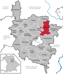
Amberg-Sulzbach is a Landkreis (district) in Bavaria, Germany. It surrounds but does not include the city of Amberg. It is bounded by the districts of Neustadt an der Waldnaab, Schwandorf, Neumarkt, Nürnberger Land and Bayreuth.

<span class="mw-page-title-main">Auerbach in der Oberpfalz</span> Town in Bavaria, Germany

Auerbach in der Oberpfalz is a town in the Amberg-Sulzbach district, Bavaria, Germany. In the subdivision Michelfeld there was a Benedictine monastery which is now a nursing home.

<span class="mw-page-title-main">Tirschenreuth</span> Town in Bavaria, Germany

Tirschenreuth is the capital city of the district of Tirschenreuth. It is located in the northeast of Bavaria, very close to the Czech-Bavarian border.

<span class="mw-page-title-main">Freudenberg, Bavaria</span> Municipality in Bavaria, Germany

Freudenberg is a municipality in the Amberg-Sulzbach district, in Bavaria, Germany. It is situated approximately 10 km north-east of Amberg.

<span class="mw-page-title-main">Sulzbach-Rosenberg</span> Town in Bavaria, Germany

Sulzbach-Rosenberg is a municipality in the Amberg-Sulzbach district, in Bavaria, Germany. It is situated approximately 14 km northwest of Amberg, and 50 km east of Nuremberg. The town consists of two parts: Sulzbach in the west, and Rosenberg in the east.

<span class="mw-page-title-main">Kümmersbruck</span> Municipality in Bavaria, Germany

Kümmersbruck is a municipality in the Amberg-Sulzbach district, in the state of Bavaria, Germany. It is situated 3 km southeast of Amberg. A division of the German Military is stationed here. Kümmersbruck is split up in 7 districts: Kümmersbruck, Haselmühl, Gärmersdorf, Moos, Haidweiher, Penkhof, Lengenfeld and Engelsdorf. The river Vils crosses the municipality.

<span class="mw-page-title-main">Schnaittenbach</span> Town in Bavaria, Germany

Schnaittenbach is a town in the Amberg-Sulzbach district, in Bavaria, Germany. It is situated 16 km northeast of Amberg.

<span class="mw-page-title-main">Königstein, Bavaria</span> Municipality in Bavaria, Germany

Königstein, also referred to as Königstein (Oberpfalz) to distinguish it from other places named Königstein, is a market town in the Amberg-Sulzbach district, Bavaria, Germany. It is located 45 kilometres (28 mi) NE of Nuremberg.

<span class="mw-page-title-main">Ebermannsdorf</span> Municipality in Bavaria, Germany

Ebermannsdorf is a municipality in the district of Amberg-Sulzbach in Bavaria in Germany.

<span class="mw-page-title-main">Edelsfeld</span> Municipality in Bavaria, Germany

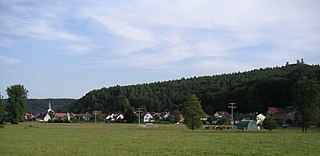
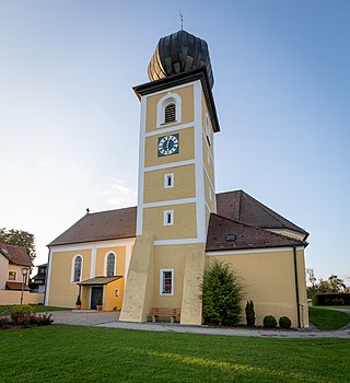
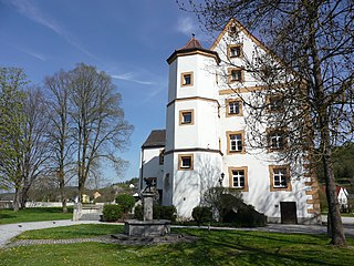
Edelsfeld is a municipality in the district of Amberg-Sulzbach in Bavaria, Germany.

<span class="mw-page-title-main">Gebenbach</span> Municipality in Bavaria, Germany

Gebenbach is a municipality in the district of Amberg-Sulzbach in Bavaria in Germany.

<span class="mw-page-title-main">Hirschbach, Bavaria</span> Municipality in Bavaria, Germany

Hirschbach is a municipality in the district of Amberg-Sulzbach in Bavaria in Germany.

<span class="mw-page-title-main">Hohenburg, Bavaria</span> Municipality in Bavaria, Germany

Hohenburg is a municipality in the district of Amberg-Sulzbach in Bavaria in Germany.

<span class="mw-page-title-main">Poppenricht</span> Municipality in Bavaria, Germany

Poppenricht is a municipality in the district of Amberg-Sulzbach in Bavaria in Germany.

<span class="mw-page-title-main">Rieden, Upper Palatinate</span> Municipality in Bavaria, Germany

Rieden is a municipality in the district of Amberg-Sulzbach in Bavaria in Germany.

<span class="mw-page-title-main">Schmidmühlen</span> Municipality in Bavaria, Germany

Schmidmühlen is a municipality in the district of Amberg-Sulzbach in Bavaria in Germany. It is situated at the junction of the Vils and Lauterach rivers.

<span class="mw-page-title-main">Ursensollen</span> Municipality in Bavaria, Germany

Ursensollen is a municipality in the district of Amberg-Sulzbach in Bavaria in Germany.

<span class="mw-page-title-main">Weigendorf</span> Municipality in Bavaria, Germany

Weigendorf is a municipality in the district of Amberg-Sulzbach in Bavaria in Germany.

<span class="mw-page-title-main">Kohlberg, Bavaria</span> Municipality in Bavaria, Germany

Kohlberg is a municipality in the district of Neustadt an der Waldnaab in Bavaria, Germany. It is situated c. 17 km (11 mi) southwest of Weiden in der Oberpfalz and c. 10 km (6.2 mi) northeast of Hirschau.

<span class="mw-page-title-main">Königswartha</span> Municipality in Saxony, Germany

Königswartha, in Sorbian Rakecy, is a municipality in the east of Saxony, Germany. It belongs to the district of Bautzen and lies 20 km north of the eponymous city.

References

  1. Liste der ersten Bürgermeister/Oberbürgermeister in kreisangehörigen Gemeinden, Bayerisches Landesamt für Statistik, 15 July 2021.
  2. Genesis Online-Datenbank des Bayerischen Landesamtes für Statistik Tabelle 12411-003r Fortschreibung des Bevölkerungsstandes: Gemeinden, Stichtag (Einwohnerzahlen auf Grundlage des Zensus 2011).
  3. "Hirschau" . Retrieved 2024-02-15.
  4. "Ortsteile mit Postleitzahl" . Retrieved 2024-02-15.
  5. "Partnerschaften" (in German). Archived from the original on 2011-08-02. Retrieved 2024-01-18.