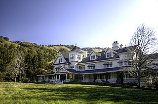
Hoberg's Resort

Last updated
Hoberg's Resort
resort
Sunset Rock at Hobergs Resort 1908, Middletown, CA (postcard).png
1908 postcard of visitors on Sunset Rock at Hoberg's
Hobergs, Lake County, CA USGS topo map.png
Hobergs on State Hwy 175 north of Pine Grove and Cobb. Vertical dashed line to the east is the boundary of Boggs Mountain Demonstration State Forest.
Relief map of California.png
Red pog.svg
Hoberg's Resort
Location in California
Usa edcp relief location map.png
Red pog.svg
Hoberg's Resort
Hoberg's Resort (the United States)
Coordinates: 38°50′37″N122°43′28″W / 38.84361°N 122.72444°W / 38.84361; -122.72444
Country United States
State California
County Lake County
Elevation
[1]
3,015 ft (919 m)

Hoberg's Resort was a holiday resort in Lake County, California. The unincorporated community of Hobergs grew up around it. The resort started out in the 1890s as a sideline where a farmer's wife offered meals to travelers, and it then became an economical place for campers and hunters to stay. It expanded, and after the founder's grandsons took over in 1934 it grew into a large and fashionable resort catering to weekend visitors who motored up from the San Francisco Bay Area. There was a swimming pool, dining hall, bar and outdoors dance floor, as well as amenities like hairdressers, a barber, resident physician, coffee shop and general store. Hollywood celebrities, politicians and businessmen stayed at the resort and were entertained by big-name musicians. By the 1960s, the resort had gone into decline, and it closed in 1971. The main building was destroyed by the 2015 Valley Fire.

Contents

Location

Hoberg's Resort was located 2.25 miles (3.6 km) north-northwest of Whispering Pines. [2] It is at an elevation of 3015 feet (919 m). [1]

Foundation

Gustav Hoberg was born in Westphalia, Germany, in 1845 and emigrated to the United States in 1860. His future wife Matilda Slotzenwall was born in Schleswig-Holstein, Germany, in 1848 and also moved to the United States. They married in Chicago in 1871, and moved to Wisconsin. In 1885 Gustav and Matilda Hoberg brought their four children to settle on a 160 acres (65 ha) property near Boggs Mountain. The property was owned by George Krammerer, a brother-in-law. Gustav paid $200 to buy another 80 acres (32 ha) beside the property. [3]

Gustav built a house, and between 1893 and 1894 he and his oldest son Max built a road from the ranch to Cobb. Matilda began offering meals to travellers who stopped by the ranch to rest their horses. The first paying guests stayed at Hoberg's in 1894. Gustav died in 1895, but Matilda and Max continued to expand the resort to earn extra income. They built several rooms where guests could receive room and board for $7 a week. George Krammerer sent friends from San Francisco, and until 1914 it mainly catered to German immigrants from the San Francisco Bay Area. Most of the visitors were hunters or campers. [3]

Growth

Max and Matilda bought out George Krammerer in 1902. That year Max married Teresa Bleus. The resort gained a telephone connection in 1914. By this time there was accommodation for 100 guests in six buildings and tents on platforms. The resort had a dining room that could sit 80, a social hall, concrete swimming pool and bowling alley. The ranch also included 25 acres (10 ha) of grain and hay, gardens, 200 chicken, cattle and an apple orchard. [3] A post office operated at Hoberg's from 1929 to 1970. [2]

In 1934 George Hoberg and his brothers Paul and Frank took over operation of the resort from their parents. [4] Also that year the Hoberg brothers, Captain Olsen [a] and his son Ernie Olsen bought Seigler Springs Resort. [7] In the 1930s new resorts oriented towards the weekend automobile crowds were developed in the region, such as Whispering Pines, Forest Lake, and Pine Grove. Many of the older resorts based on curative mineral springs did not adapt and had to close. Hoberg's and Adams Springs were exceptions. [8]

The Hoberg brothers restored and modernized Seigler Springs, and it became so popular it could not provide room for all the would-be visitors. [9] Additions to the main Hoberg's resort in the 1930s included a large dining hall, a general store and a large tiled pool. A fire in 1936 burned 80 cottages. [7] Hoberg's became what was probably the largest Lake County resort that did not contain mineral springs. [10] Well known visitors included Luther Burbank, Clark Gable, Max Baer, politicians and businessmen. [7]

Peak years

Hoberg's became California's largest privately owned resort. Big name bands played there in the 1940s and 1950s, and it was frequented by celebrities. It was capable of serving dinner to 1,000 guests. [11] 46 cottages were built on Spanish Row in 1945-1946. [7] Paul Hoberg died in 1946. [12] The Paul Hoberg Airport was dedicated in 1947, 5 miles (8.0 km) southeast of Hoberg's, just below Seigler Springs. Frank and George Hoberg both owned four small passenger planes, and both flew guests of Hoberg's resort to and from the resort. [13]

The Pine Bowl dance floor was open air, so the music could be heard throughout the resort grounds. [14] From 1945 Sal Carson and his orchestra played at Hoberg's for many years. [15] In 1946 Tommy Dorsey played there. Other big-name entertainers included Xavier Cugat and Harry James. [14] In 1947 the Freddy Martin Band played at the Pine Bowl dance floor with the singer Merv Griffin. [16] Walt Tolleson and his band played at the resort in the late 1950s. [12] At its peak in the 1950s the resort employed almost 100 people including waitresses, maids, coffee shop workers, bartenders and hairdressers. There was a physician in residence, a swimming instructor, a barber and a 12-piece orchestra. In 1956 a new auditorium was opened that could seat 1,000. [7]

Decline and sale

During the 1960s business slowly declined at Hoberg's, as it did at other Lake County resorts. Vacationers were starting to travel to more distant locations that offered more activities, and conventions started to use custom-built facilities in the large cities.George Hoberg died in 1970; the family ran the property as a boarding school for two years after his death. [12]

In 1974, the Maharishi International University bought the property. [12] As of 1989 the historic buildings of the old Hoberg resort were being used as a private retreat. [17] In July 2010, the resort was purchased by a group of investors and renovations on the building occurred two years later. [18] The resort building was destroyed by the Valley Fire in September 2015, with only the foundations and chimneys remaining intact. [19]

Notes

  1. Captain Olsen was a former steam schooner captain on the Pacific Coast, nicknamed "Midnight Olsen" from a wager that he would return before midnight Christmas eve on a trip from Eureka to San Francisco and back. Despite heavy weather, he returned just in time to win the bet. [5] He later became a pilot, guiding large freighters into and out of all the ports in California, before leaving the sea and buying into the resort. [6]

Related Research Articles

<span class="mw-page-title-main">El Dorado County, California</span> County in California, United States

El Dorado County, officially the County of El Dorado, is a county located in the U.S. state of California. As of the 2020 census, the population was 191,185. The county seat is Placerville. The county is part of the Sacramento-Roseville-Arden-Arcade, CA Metropolitan Statistical Area. It is located entirely in the Sierra Nevada, from the historic Gold Country in the western foothills to the High Sierra in the east. El Dorado County's population has grown as Greater Sacramento has expanded into the region. Where the county line crosses US 50 at Clarksville, the distance to Sacramento is 15 miles (24 km). In the county's high altitude eastern end at Lake Tahoe, environmental awareness and environmental protection initiatives have grown along with the population since the 1960 Winter Olympics, hosted at the former Squaw Valley Ski Resort in neighboring Placer County.

<span class="mw-page-title-main">Lake County, California</span> County in California, United States

Lake County is a county located in the north central portion of the U.S. state of California. As of the 2020 census, the population was 68,163. The county seat is Lakeport. The county takes its name from Clear Lake, the dominant geographic feature in the county and the largest non-extinct natural lake wholly within California.

<span class="mw-page-title-main">Henry W. Coe State Park</span> State park in California, U.S.

Henry W. Coe State Park is a state park of California, United States, preserving a vast tract of the Diablo Range. The park is located closest to the city of Morgan Hill, and is located in both Santa Clara and Stanislaus counties. The park contains over 87,000 acres (35,000 ha), making it the largest state park in northern California, and the second-largest in the state. Managed within its boundaries is a designated wilderness area of about 22,000 acres (8,900 ha). This is officially known as the Henry W. Coe State Wilderness, but locally as the Orestimba Wilderness. The 89,164-acre (36,083 ha) park was established in 1959.

<span class="mw-page-title-main">Palomar Mountain</span> Mountain in San Diego County, California, United States

Palomar Mountain is a mountain ridge in the Peninsular Ranges in northern San Diego County, California. It is known as the location of Palomar Observatory and Hale Telescope, and known for Palomar Mountain State Park.
<span class="mw-page-title-main">Harbin Hot Springs</span> Retreat in California, United States

Harbin Hot Springs is a hot spring retreat and workshop center situated at Harbin Springs in Lake County, Northern California. Operated by Heart Consciousness Church, a non-profit, it is named after Matthew Harbin, a pioneer who settled in the Lake County area. Located approximately two hours north of the San Francisco Bay Area, in the United States, the facility suffered partial destruction in the Valley Fire in September 2015, resulting in its temporary closure. It partially reopened in January 2019, including the main pools and sauna, along with a limited cafeteria service.
<span class="mw-page-title-main">Tassajara Hot Springs</span> Thermal springs in California

Tassajara Hot Springs is a collection of natural hot springs within the Ventana Wilderness area of the Santa Lucia Range and Los Padres National Forest in Monterey County, California. The hot springs were used by the indigenous Native Americans for generations before they were discovered by Europeans in about 1843. The springs have been the site of various resorts since 1868. A horse trail was in use until in 1886, when a stagecoach road was constructed over Chews Ridge to the springs. Monterey County designated the road to the resort as a public highway in June, 1870. Charles Quilty bought the resort in 1886. He had a sandstone hotel built. He and members of his family owned the springs until 1945. The new owners refurbished the hotel but it burned in a fire in 1949. The resort changed hands several times over the next three decades. One owner planned to add a helicopter service, but he was killed in an airplane crash. Since 1967, the hot springs have been the site of a Zen Buddhist monastery which is open to visitors during the summer months only.

Whispering Pines is an unincorporated community in Lake County, California. It is located 8.5 miles (14 km) southwest of Lower Lake, at an elevation of 2641 feet. It is located south of Loch Lomond. The ZIP Code is 95461. The community is inside area code 707.
<span class="mw-page-title-main">Aetna Springs Resort</span> Historic resort in California, United States

The Aetna Springs Resort is a historic resort located in Pope Valley in the north eastern part of Napa County, California, United States. It is listed on the National Register of Historic Places.

<span class="mw-page-title-main">Adams, California</span> Resort in California, United States

Adams is an unincorporated community in Lake County, California. It was formerly Adams Springs, a summer resort developed around a small group of mineral water springs.

<span class="mw-page-title-main">Forest Lake Resort</span> Resort in California, United States

Forest Lake Resort was a resort in the Cobb Mountain area of Lake County, California, in an area of wet meadows along Kelsey Creek. Originally a campground, it was developed into a resort in the 1930s to exploit the growing automobile-based recreation market. The resort was sold in 1963. By 1989 it was longer operational, and was being considered for development as a community park site.

Glenbrook was a resort in Lake County, California. It was located 10 miles (16 km) south-southeast of Kelseyville, at an elevation of 2293 feet.

<span class="mw-page-title-main">Howard Springs, California</span> Resort in California, United States

Howard Springs is a set of springs turned into a resort in the 1870s in Lake County, California. The resort catered primarily to people interested in the curative powers of the mineral waters. Guests were accommodated in cabins or tents. At one time it had an official post office. The resort changed hands many times over the years, with various changes to the lodge, accommodations and bathhouses, until closing in 1970. For a period it was leased for geothermal exploration. Today it has reopened as a health resort.

<span class="mw-page-title-main">Seigler Springs, California</span> Unincorporated community in California, United States

Seigler Springs is a set of springs in Lake County, California around which a resort developed in the 19th century. In the 1930s the resort was expanded, and in 1947 an airport opened nearby. The resort declined in the 1960s. Part of it was separated out and became a residential subdivision, while part became a religious retreat. The 2015 Valley Fire caused great damage.

<span class="mw-page-title-main">Valley Fire</span> 2015 wildfire in Northern California

The Valley Fire was a wildfire during the 2015 California wildfire season that started on September 12 in Lake County, California. It began shortly after 1:00 pm near Cobb with multiple reports of a small brush fire near the intersection of High Valley and Bottlerock Roads. It quickly spread and by 6:30 PM PDT, it had burned more than 10,000 acres (40 km2). By Sunday, the thirteenth of September, the fire had reached 50,000 acres (202 km2) and had destroyed much of Cobb, Middletown, Whispering Pines, and parts in the south end of Hidden Valley Lake. The fire ultimately spread to 76,067 acres (308 km2), killed four people and destroyed nearly 2,000 buildings, before it was fully contained on October 15, 2015, causing at least $921 million in insured property damage. At the time, the fire was the third-most destructive fire in California history, based on the total structures burned, but the Camp Fire (2018) and the North Complex fire in 2020, exceeded that total.

<span class="mw-page-title-main">Independence Lake (California)</span> Lake in the state of California, United States

Independence Lake is a natural glacial lake in the Sierra Nevada of California. At an elevation of 6,949 feet (2,118 m) in the upper reaches of the Truckee River basin, it has been less affected by development than most lakes in the area. The Nature Conservancy owns a 2,325 acres (9.41 km2) parcel of land around it, which it manages privately as the Independence Lake Preserve for the purposes of conservation and low-impact recreation.

<span class="mw-page-title-main">Boggs Mountain</span> Mountain in the state of California

Boggs Mountain is a mountain the Mayacamas Mountains in Lake County, California. Part of the mountain holds the Boggs Mountain Demonstration State Forest. About 80% of the trees were burned in the September 2015 Valley Fire.

<span class="mw-page-title-main">Kelsey Creek (Lake County)</span> Watercourse in Lake Country, California, United States

Kelsey Creek is a watercourse in Lake County, California, United States, that feeds Clear Lake from the south. Originally forest-covered, the watershed has been converted in the lower parts to farmland and for urban use. Higher up, the forests have been cleared, regrown, and cleared again. The northern part of the creek flows through a geothermal field that feeds power plants and hot springs. The wooded Cobb area in the higher part of the watershed was once home to resorts as early as the 1850s.

<span class="mw-page-title-main">Paul Hoberg Airport</span> Former airport in Lake County, California

The Paul Hoberg Airport, or simply Hobergs Airport is an abandoned airport in Lake County, California, United States. It was opened in 1947 for use by guests of the nearby Hoberg's Resort, and was busy until the 1960s. By 1982 it had been abandoned.
<span class="mw-page-title-main">George Hoberg</span>

George Gustave Hoberg was a Californian businessman. With his brothers he ran Hoberg's Resort in Lake County, California for many years.

Seigler Mountain is a mountain in the Mayacamas Mountains of the Northern California Coast Ranges. It is in Lake County, California.

References

  1. 1 2 Hobergs USGS.
  2. 1 2 Durham 1998, p. 77.
  3. 1 2 3 The Beginning... HHA.
  4. California Senate 1972, p. 1.
  5. Larson 1953, p. 5–6.
  6. Larson 1953, p. 6.
  7. 1 2 3 4 5 The Road to Fame.
  8. Lake County Planning Department 1989, p. 3.22.
  9. Feltman 1993.
  10. Hoberg 2007, p. 61.
  11. Freeman 2020.
  12. 1 2 3 4 Hoberg 2007, p. 108.
  13. Hoberg 2007, p. 99.
  14. 1 2 Hoberg 2007, p. 106.
  15. Hoberg 2007, p. 107.
  16. Hoberg 2007, p. 101.
  17. Lake County Planning Department 1989, p. 3.23.
  18. Larson 2012.
  19. Rossman & Payne 2015.

Sources

  • California Senate (1972), Senate Bills, California Legislature
  • Durham, David L. (1998). California's Geographic Names: A Gazetteer of Historic and Modern Names of the State. Clovis, Calif.: Word Dancer Press. p. 77. ISBN   1-884995-14-4.
  • Feltman, Erving R (1 January 1993), California's Lake County: Places and postal history, The Depot, ISBN   978-0943645285
  • Freeman, Paul (16 December 2020), "Paul Hoberg Airport, Siegler Springs, CA", Abandoned & Little-Known Airfields: California: Santa Rosa Area
  • Hoberg, Donna (2007). Resorts of Lake County. Arcadia Publishing. ISBN   9780738547985.
  • "Hobergs", Geographic Names Information System , United States Geological Survey, United States Department of the Interior
  • Lake County Planning Department (May 1989), Cobb Mountain Area Plan (PDF) (draft), Lake County Board of Supervisors, archived from the original (PDF) on 2021-04-23, retrieved 2021-05-20
  • Larson, John W. (March 1953), Oral History Interview with Caspar Hexberg, San Francisco, California (PDF), St. Paul, Minnesota: Forest History Foundation, Inc., retrieved 2021-04-28
  • Larson, Elizabeth (29 June 2012), "Hobergs Resort prepares for renovations; seeks crew to carry out work", Lake County News
  • Rossman, Randi; Payne, Paul (September 13, 2015). "Valley Fire: Devastation during the night as fire destroys homes". Santa Rosa Press Democrat . Retrieved September 13, 2015.
  • The Beginning..., Hoberg's Historical Association, retrieved 2021-05-20
  • The Road to Fame, Hoberg's Historical Association, retrieved 2021-05-20