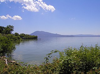
Lake County is a county located in the north central portion of the U.S. state of California. As of the 2020 census, the population was 68,163. The county seat is Lakeport. The county takes its name from Clear Lake, the dominant geographic feature in the county and the largest non-extinct natural lake wholly within California.

Cobb is a census designated place (CDP) in Lake County, California, United States. Cobb is located 1 mile (1.6 km) northwest of Whispering Pines, at an elevation of 2,631 feet (802 m). The population was 1,778 at the 2010 census, up from 1,638 at the 2000 census.
Middletown is a census-designated place (CDP) in Lake County, California, United States. Its population was 725 at the 2020 census down from 1,323 at the 2010 census, which was up slightly from 1,020 at the 2000 census. Middletown was given its name because it is halfway between Lower Lake and Calistoga, which is 17 miles (27 km) to the south. The town was severely damaged by the 2015 Valley Fire.
Harbin Hot Springs is a non-profit hot spring retreat and workshop center at Harbin Springs in Lake County, Northern California. Named after Matthew Harbin, a pioneer who settled in the Lake County area. It is located about two hours northeast of the San Francisco Bay Area, in the United States. The facility was partially destroyed in the Valley Fire in September 2015, and was temporarily closed. In January 2019 it partially reopened, including the main pools and sauna, and a limited cafeteria service.

Lake Hughes is an unincorporated community in northern Los Angeles County, California. It is in the Sierra Pelona Mountains, northwest of Palmdale and north of the Santa Clarita Valley, in the Angeles National Forest. It is on the sag pond waters of Lake Hughes and Elizabeth Lake. The community is rural in character, with a population of 649 in 2010, but also has a strong recreational element centered on the three lakes in the vicinity. The community of Elizabeth Lake is located just east of Lake Hughes, sharing the same ZIP code.
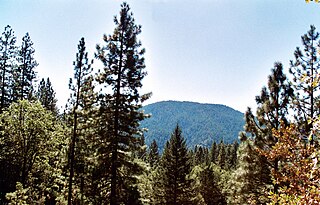
Cobb Mountain is the tallest mountain in the Mayacamas Mountains of California.

Loch Lomond is an unincorporated community in Lake County, California. It lies at an elevation of 2,818 feet. It is located on State Route 175 north of the village of Cobb; 3.5 miles (5.6 km) north of Whispering Pines. The ZIP code is 95461, which is shared with Middletown. Unofficially, and perhaps incorrectly, 95426, which belongs to neighboring Cobb, California is often used. The community is inside area code 707.
Whispering Pines is an unincorporated community in Lake County, California. It is located 8.5 miles (14 km) southwest of Lower Lake, at an elevation of 2641 feet. It is located south of Loch Lomond. The ZIP Code is 95461. The community is inside area code 707.
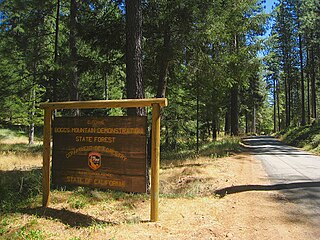
Boggs Mountain Demonstration State Forest is a state forest in Lake County, California that covers the northwest of Boggs Mountain. It was founded in 1949, and came into operation in 1950 when most of the site had been clear cut. The purpose was to demonstrate good practices in restoring and managing a forest. The state forest was open for recreational use, including camping, hiking, mountain biking etc. The 2015 Valley Fire destroyed 80% of the trees. The state forest as of 2021 was replanting saplings.

Adams is an unincorporated community in Lake County, California. It was formerly Adams Springs, a summer resort developed around a small group of mineral water springs.

Forest Lake Resort was a resort in the Cobb Mountain area of Lake County, California, in an area of wet meadows along Kelsey Creek. Originally a campground, it was developed into a resort in the 1930s to exploit the growing automobile-based recreation market. The resort was sold in 1963. By 1989 it was longer operational, and was being considered for development as a community park site.
Glenbrook was a resort in Lake County, California. It was located 10 miles (16 km) south-southeast of Kelseyville, at an elevation of 2293 feet.

Seigler Springs is a set of springs in Lake County, California around which a resort developed in the 19th century. In the 1930s the resort was expanded, and in 1947 an airport opened nearby. The resort declined in the 1960s. Part of it was separated out and became a residential subdivision, while part became a religious retreat. The 2015 Valley Fire caused great damage.

The Valley Fire was a wildfire during the 2015 California wildfire season that started on September 12 in Lake County, California. It began shortly after 1:00 pm near Cobb with multiple reports of a small brush fire near the intersection of High Valley and Bottlerock Roads. It quickly spread and by 6:30 PM PDT, it had burned more than 10,000 acres (40 km2). By Sunday, the thirteenth of September, the fire had reached 50,000 acres (202 km2) and had destroyed much of Cobb, Middletown, Whispering Pines, and parts in the south end of Hidden Valley Lake. The fire ultimately spread to 76,067 acres (308 km2), killed four people and destroyed nearly 2,000 buildings, before it was fully contained on October 15, 2015, causing at least $921 million in insured property damage.n" /> At the time, the fire was the third-most destructive fire in California history, based on the total structures burned, but the Camp Fire (2018) and the North Complex fire in 2020, exceeded that total.
Anderson Springs is a set of hot springs and a resort in Lake County, California. It is located at an elevation of 1411 feet.
Boggs Mountain is a mountain the Mayacamas Mountains in Lake County, California. Part of the mountain holds the Boggs Mountain Demonstration State Forest. About 80% of the trees were burned in the September 2015 Valley Fire.

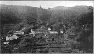
Kelsey Creek is a watercourse in Lake County, California, United States, that feeds Clear Lake from the south. The watershed was forest-covered. In the lower parts it has been converted to farmland and for urban use. Higher up the forests have been cleared, regrown and cleared again. The northern part of the creek flows through a geothermal field that feeds power plants and hot springs. The wooded Cobb area in the higher part of the watershed holds resorts and resort communities, some dating to the 1850s.

Hoberg's Resort was a holiday resort in Lake County, California. The unincorporated community of Hobergs grew up around it. The resort started out in the 1890s as a sideline where a farmer's wife offered meals to travelers, and it then became an economical place for campers and hunters to stay. It expanded, and after the founder's grandsons took over in 1934 it grew into a large and fashionable resort catering to weekend visitors who motored up from the San Francisco Bay Area. There was a swimming pool, dining hall, bar and outdoors dance floor, as well as amenities like hairdressers, a barber, resident physician, coffee shop and general store. Hollywood celebrities, politicians and businessmen stayed at the resort and were entertained by big-name musicians. By the 1960s, the resort had gone into decline, and it closed in 1971. The main building was destroyed by the 2015 Valley Fire.

The Paul Hoberg Airport, or simply Hobergs Airport is an abandoned airport in Lake County, California, United States. It was opened in 1947 for use by guests of the nearby Hoberg's Resort, and was busy until the 1960s. By 1982 it had been abandoned.
Seigler Mountain is a mountain in the Mayacamas Mountains of the Northern California Coast Ranges. It is in Lake County, California.


