Hochstadt am Main

Last updated
Hochstadt a.Main
Hochstadt-Bezirksklinik.jpg
Hospital in Hochstadt am Main
DEU Hochstadt am Main COA.svg
Location of Hochstadt a.Main within Lichtenfels district
Hochstadt am Main in LIF.svgNeuensorger ForstBreitengüßbacher ForstLichtenfels
Germany adm location map.svg
Red pog.svg
Hochstadt a.Main
Bavaria location map.svg
Red pog.svg
Hochstadt a.Main
Coordinates: 50°8′N11°10′E / 50.133°N 11.167°E / 50.133; 11.167 Coordinates: 50°8′N11°10′E / 50.133°N 11.167°E / 50.133; 11.167
Country Germany
State Bavaria
Admin. region Oberfranken
District Lichtenfels
Municipal assoc. Hochstadt-Marktzeuln
Subdivisions7 Ortsteile
Government
   Mayor (202026) Max Zeulner [1] (CSU)
Area
  Total13.79 km2 (5.32 sq mi)
Elevation
281 m (922 ft)
Population
 (2021-12-31) [2]
  Total1,625
  Density120/km2 (310/sq mi)
Time zone UTC+01:00 (CET)
  Summer (DST) UTC+02:00 (CEST)
Postal codes
96272
Dialling codes 09574
Vehicle registration LIF/STE
Website www.hochstadt-main.de

Hochstadt am Main is a municipality in the district of Lichtenfels in Bavaria in Germany. It lies on the river Main.

Related Research Articles

<span class="mw-page-title-main">Creußen</span> Town in Bavaria, Germany

Creußen is a town in the district of Bayreuth in Bavaria, Germany. It is situated on the Red Main river, 13 km southeast of Bayreuth.

<span class="mw-page-title-main">Marktsteft</span> Town in Bavaria, Germany

Marktsteft is a town in the district of Kitzingen, in Bavaria, Germany. It is situated on the left bank of the Main, 5 km (3 mi) southwest of Kitzingen.

<span class="mw-page-title-main">Weidenberg</span> Municipality in Bavaria, Germany

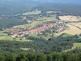
Weidenberg is a municipality in the district of Bayreuth in Bavaria in Germany. The Ölschnitz river discharges near Weidenberg-Neunkirchen into the Red Main.

<span class="mw-page-title-main">Zell am Main</span> Municipality in Bavaria, Germany

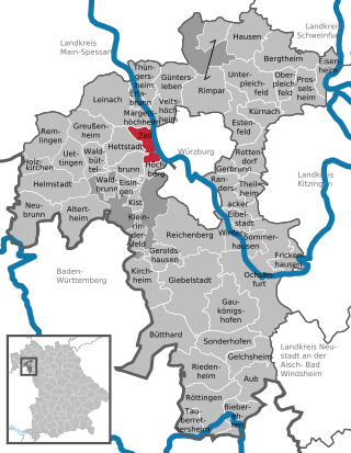
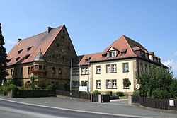
Zell am Main is a municipality in the district of Würzburg in Bavaria in Germany, situated on the river Main.

<span class="mw-page-title-main">Möhrendorf</span> Town in Bavaria, Germany

Möhrendorf is a town in the district of Erlangen-Höchstadt, in Bavaria, Germany. It lies on the river Regnitz and the Rhine-Main-Danube Canal.

<span class="mw-page-title-main">Seehausen am Staffelsee</span> Municipality in Bavaria, Germany

Seehausen am Staffelsee is a municipality in the district of Garmisch-Partenkirchen, in Bavaria, Germany. The main village, Seehausen, lies on the eastern shore of the Staffelsee lake.

<span class="mw-page-title-main">Gädheim</span> Municipality in Bavaria, Germany

Gädheim is a municipality in the district of Haßberge in Bavaria in Germany. It lies in the Main river valley.

<span class="mw-page-title-main">Pfarrweisach</span> Municipality in Bavaria, Germany

Pfarrweisach is a municipality in the district of Haßberge in Bavaria in Germany.

<span class="mw-page-title-main">Sand am Main</span> Municipality in Bavaria, Germany

Sand is a municipality in the district of Haßberge in Bavaria in Germany. It lies on the river Main.

<span class="mw-page-title-main">Nordheim am Main</span> Municipality in Bavaria, Germany

Nordheim am Main is a municipality in the district of Kitzingen in Bavaria in Germany.

<span class="mw-page-title-main">Schwarzach am Main</span> Municipality in Bavaria, Germany

Schwarzach am Main is a market town and municipality in the district of Kitzingen in Bavaria in Germany. It lies on the river Main.

<span class="mw-page-title-main">Sommerach</span> Municipality in Bavaria, Germany

Sommerach is a municipality in the district of Kitzingen in Bavaria in Germany.

<span class="mw-page-title-main">Röthlein</span> Municipality in Bavaria, Germany

Röthlein is a municipality in the district of Schweinfurt in Bavaria, Germany. The village is located south of Schweinfurt, close to the Main valley. The quarters are Röthlein, Heidenfeld and Hirschfeld.

<span class="mw-page-title-main">Üchtelhausen</span> Municipality in Bavaria, Germany

Üchtelhausen is a municipality and community in the district of Schweinfurt in Bavaria, Germany.

<span class="mw-page-title-main">Margetshöchheim</span> Municipality in Bavaria, Germany

Margetshöchheim is a municipality in the district of Würzburg in Bavaria, Germany. It lies on the left bank of the river Main.

<span class="mw-page-title-main">Sulzfeld am Main</span> Municipality in Bavaria, Germany

Sulzfeld am Main is a municipality in the district of Kitzingen in Bavaria in Germany.

<span class="mw-page-title-main">Eisenheim</span> Municipality in Bavaria, Germany

Eisenheim is a market town and municipality in the district of Würzburg in Bavaria, Germany. It lies on the river Main.

<span class="mw-page-title-main">Frickenhausen am Main</span> Municipality in Bavaria, Germany

Frickenhausen am Main is a municipality in the district of Würzburg in Bavaria, Germany. It lies on the river Main. Frickenhausen is one of the oldest towns of Mainfranken with a beautiful town center.

<span class="mw-page-title-main">Sandberg, Bavaria</span> Municipality in Bavaria, Germany

Sandberg is a municipality in the district of Rhön-Grabfeld in Bavaria in Germany.

<span class="mw-page-title-main">Theres</span> Municipality in Bavaria, Germany

Theres is a municipality on the river Main, in the district of Haßberge in Bavaria in Germany. It was once the site of Theres Abbey, but the church was demolished in 1809.

References

  1. Liste der ersten Bürgermeister/Oberbürgermeister in kreisangehörigen Gemeinden, Bayerisches Landesamt für Statistik, 15 July 2021.
  2. "Tabelle 12411-003r Fortschreibung des Bevölkerungsstandes: Gemeinden, Stichtag" (in German). Bayerisches Landesamt für Statistik. June 2022.