Lichtenfels, Bavaria

Last updated
Lichtenfels
Lichtenfels Ofr - Marktplatz 1 - Rathaus.jpg
Town hall
DEU Lichtenfels COA.svg
Location of Lichtenfels within Lichtenfels district
Lichtenfels in LIF.svgNeuensorger ForstBreitengüßbacher ForstLichtenfels
Germany adm location map.svg
Red pog.svg
Lichtenfels
Bavaria location map.svg
Red pog.svg
Lichtenfels
Coordinates: 50°08′N11°02′E / 50.133°N 11.033°E / 50.133; 11.033
Country Germany
State Bavaria
Admin. region Oberfranken
District Lichtenfels
Government
   Mayor (202026) Andreas Hügerich [1] (SPD)
Area
  Total122.27 km2 (47.21 sq mi)
Elevation
271 m (889 ft)
Population
 (2022-12-31) [2]
  Total20,217
  Density170/km2 (430/sq mi)
Time zone UTC+01:00 (CET)
  Summer (DST) UTC+02:00 (CEST)
Postal codes
96215
Dialling codes 09571
Vehicle registration LIF, STE
Website www.lichtenfels.de

Lichtenfels is a town in the Upper Franconian region of Bavaria, Germany, the administrative seat of Lichtenfels district. It is chiefly known as the German "Basket City".

Contents

Geography

It is situated on the upper course of the river Main, about 15 kilometres (9.3 mi) southeast of Coburg, and 30 kilometres (19 mi) northeast of Bamberg. The hilly landscape is called Gottesgarten am Obermain ("God's garden on the upper Main"), referring to the Basilica of the Fourteen Holy Helpers and Banz Abbey. The Maintal (valley of the Main) goes from East to West. The most important cities of the district are Burgkunstadt, Bad Staffelstein and the district city of Lichtenfels. The Rodach river, a tributary of the Main, runs through the area and reaches its greatest width in the northern part between Hochstadt am Main and Lichtenfels.

The district of Lichtenfels lies in the western part of the government region (Regierungsbezirk) of Oberfranken (Upper Franconia). It is surrounded by (from the north and clockwise) the districts of Coburg, Kronach, Kulmbach, Bayreuth and Bamberg.

The southern bank of the Main stretches up to the mountain range of the Franconian Jura (Fränkische Alb) beneath the Staffelberg close to Bad Staffelstein. The northern bank of the Main stretches up to the Itz-Baunach Highlands.

Administrative division

The town is divided into several districts:

Buch am Forst, Degendorf, Eichig, Gnellenroth, Hammer, Isling, Klosterlangheim, Kösten, Köttel, Krappenroth, Lahm, Mistelfeld, Mönchkröttendorf, Oberlangheim, Oberwallenstadt, Reundorf, Roth, Rothmannsthal, Schney, Schönsreuth, Seehof, Seubelsdorf, Stetten, Stöcken, Tiefenroth, Trieb, Unterwallenstadt und Weingarten.

History

Lichtenfels was first mentioned in 1142 and chartered in 1231. That was titled and conferred from Otto III, Count Palatine of Burgundy.

After the expiration of the Meranians (Meranier) in 1248 Lichtenfels became part of the Prince-Bishopric of Bamberg (Hochstift Bamberg). With those and with the Secularization in 1802 incorporate to the Prince-electorate (Kurfürstentum) and later to the Kingdom of Bavaria (Königreich Bayern).

The Lichtenfelser are also called, in a sneering kind of way, the scoopers of the pool (Tümpelschöpfer). This name they obtained from the Thirty Years' War (1618–1648), from attempting to retrieve hidden sunken treasures in a pond, which they could not empty out due to rapidly running groundwater.

Economy

Owing to the success of numerous local middle class enterprises, the town of 20,000 has an above average occupational quota.

The backbone of the local economy is formed by businesses in various industry sectors such as manufacturing, with an upholstery industry and its suppliers as well as wood processing and the production of foamed material. Other businesses include machine and tool fabrication, laser technology and one international cargo carrier.

Basket making

The Korbmarkt Lichtenfels Korbmarkt baskets.jpg
The Korbmarkt
The Korbmarkt Lichtenfels Korbmarkt baskets2.jpg
The Korbmarkt

Lichtenfels became a centre of basket making in the middle of the 19th century. The basket makers in the surrounding upper Maintal area brought their products to trade in Lichtenfels, which was and is the biggest retail market. The leading entrepreneur was the basket dealer Joseph Crinkly.

Since 1904, there has been a technical basket college, and as of 1912 there was also a braiding course for women. Those fashioned and very frequent outwork baskets came from the whole family.

After the First World War Lichtenfels became known as the seat of the German wicker or basket-making industry. The period saw the gradual extinction of basket making in Germany. After the Second World War Lichtenfels was the main remaining basket dealer and today as an exclusive exporter of the braiding manufactures.

Lichtenfels is the basket-making capital of Germany and has the only college which still teaches the old craft skills. Each year at the end of September the Korbmarkt (Basket Market) is held when the town is filled with stalls selling baskets from many countries and one can watch many craftspeople at work. On the Market Place in front of the town hall there is the World's largest gift basket.

Transport

Road

Coburg can be reached by car via B 173 Lichtenfels-Hof-Dresden or motorway A 73 Suhl-Lichtenfels-Nuremberg.

Railways

Lichtenfels station is on the Eisenach–Lichtenfels and Bamberg-Hof main lines. The Franconian Forest Railway turns off from Bamberg-Hof railway near Lichtenfels. It is a regional rail hub and a former ICE stop.

Notable people

Andreas Roschlaub Ferdinand Piloty d. A. - Andreas Roschlaub.jpg
Andreas Röschlaub

Twin towns – sister cities

Lichtenfels is twinned with: [3]

See also

Related Research Articles

<span class="mw-page-title-main">Franconia</span> Cultural region of Germany in Bavaria

Franconia is a region of Germany, characterised by its culture and Franconian dialect. While several Germanic dialects are referred to as Franconian, only the East Franconian dialects are also colloquially referred to as "Franconian", and only the East Franconian dialect area is regarded as Franconia.

<span class="mw-page-title-main">Upper Franconia</span> Regierungsbezirk in Bavaria, Germany

Upper Franconia is a Regierungsbezirk of the state of Bavaria, southern Germany. It forms part of the historically significant region of Franconia, the others being Middle Franconia and Lower Franconia, which are all now part of the German Federal State of Bayern (Bavaria).

Bamberg is a Landkreis (district) in Bavaria, Germany. It surrounds but does not include the town of Bamberg. The district is bounded by the districts of Lichtenfels, Bayreuth, Forchheim, Erlangen-Höchstadt, Neustadt (Aisch)-Bad Windsheim, Kitzingen, Schweinfurt and Haßberge.

Kronach is a Landkreis (district) in Bavaria, Germany. It is bounded by the districts of Hof, Kulmbach, Lichtenfels and Coburg, and the state of Thuringia.

Kulmbach is a Landkreis (district) in Bavaria, Germany. It is bounded by the districts of Kronach, Hof, Bayreuth and Lichtenfels.

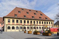
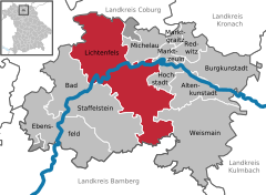
Lichtenfels is a Landkreis (district) in Bavaria, Germany. It is bounded by the districts of Coburg, Kronach, Kulmbach, Bayreuth and Bamberg.

<span class="mw-page-title-main">Kulmbach</span> Town in Bavaria, Germany

Kulmbach is the capital of the district of Kulmbach in Bavaria in Germany. The town, once a stronghold of the Principality of Bayreuth, is renowned for its massive Plassenburg Castle, which houses the largest tin soldier museum in the world, and for its sausages, or Bratwürste.

<span class="mw-page-title-main">Bad Staffelstein</span> Town in Bavaria, Germany

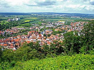
Bad Staffelstein is a small town in the Bavarian Administrative Region of Upper Franconia in Germany. It has around 10,000 inhabitants.

<span class="mw-page-title-main">Ludwigsstadt</span> Town in Bavaria, Germany

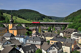
Ludwigsstadt is a town in the district of Kronach, in the Upper Franconian region of Bavaria, Germany.

<span class="mw-page-title-main">Schlüsselfeld</span> Town in Bavaria, Germany

Schlüsselfeld is a town on the southwestern edge of the Upper Franconian district (Landkreis) of Bamberg

<span class="mw-page-title-main">Zeil am Main</span> Town in Bavaria, Germany

Zeil am Main is a town in the Haßberge district in Lower Franconia, an area in the federal state of Bavaria, Germany. It is situated on the right bank of the Main, 7 km east of Haßfurt, 24 km northwest of Bamberg, and 25 km east of Schweinfurt. Zeil is a historic Franconian town known for its old churches, romantic houses, medieval walls and towers, the hill church of "Zeiler Käpelle", and the castle ruins of the Schmachtenburg.

<span class="mw-page-title-main">Breitengüßbach</span> Municipality in Bavaria, Germany

Breitengüßbach is a community in the Upper Franconian district of Bamberg. It was first mentioned as Gusibach and as belonging to the royal court at Hallstadt in an Imperial document issued between 812 and 830.

<span class="mw-page-title-main">Pettstadt</span> Municipality in Bavaria, Germany

Pettstadt is a community in the Upper Franconian district of Bamberg with about 1,900 inhabitants.

<span class="mw-page-title-main">Rattelsdorf</span> Municipality in Bavaria, Germany

Rattelsdorf is a municipality with market rights in the Upper Franconian district of Bamberg.

<span class="mw-page-title-main">Zapfendorf</span> Municipality in Bavaria, Germany

Zapfendorf is a municipality with market rights in the Upper Franconian district of Bamberg in Bavaria, Germany with roughly 5,000 inhabitants.

<span class="mw-page-title-main">Sonnefeld</span> Municipality in Bavaria, Germany

Sonnefeld is a municipality in the district of Coburg in Bavaria in Germany.

<span class="mw-page-title-main">Bamberg–Hof railway</span>

The Bamberg–Hof railway is a 127 kilometre-long main line that runs through Bavaria in southern Germany. The line runs from Bamberg via Lichtenfels, Kulmbach, Neuenmarkt-Wirsberg and Münchberg to Hof. The section from Hof to Neuenmarkt now forms part of the Saxon-Franconian trunk line.

<span class="mw-page-title-main">Lichtenfels station</span>

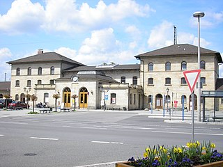
Lichtenfels station is in the town of Lichtenfels in Upper Franconia in the German state of Bavaria. It is a regional rail hub and a former ICE stop on the Hamburg–Berlin Munich route and is classified by Deutsche Bahn as a station of category 3.

<span class="mw-page-title-main">Buch am Forst</span> Ortsteil of Lichtenfels in Bavaria, Germany

Buch am Forst is a village of 530 inhabitants in the district town (Kreisstadt) of Lichtenfels in the state of Bavaria in Germany. It is 6 kilometers northwest of Lichtenfels and at the western edge of the Lichtenfels Forest. Bundesautobahn 73 [Federal Highway] runs approximately a half-mile (1 km) to the east, while Kreisstraße [District Road] LIF27 goes through the village itself.

<span class="mw-page-title-main">Itzgründisch dialect</span> East Franconian dialect of Germany

Itzgründisch is an East Franconian dialect, which is spoken in the eponymous Itz Valley and its tributaries of Grümpen, Effelder, Röthen/Röden, Lauter, Füllbach and Rodach, the valleys of the Neubrunn, Biber and the upper Werra and in the valley of Steinach. In the small language area, which extends from the Itzgrund in Upper Franconia to the southern side of the Thuringian Highlands, East Franconian still exists in the original form. Because of the remoteness of the area, this isolated by the end of the 19th century and later during the division of Germany, this language has kept many linguistic features to this day. Scientific study of the Itzgründisch dialect was made for the first time, in the middle of the 19th century, by the linguist August Schleicher.

References

  1. Liste der ersten Bürgermeister/Oberbürgermeister in kreisangehörigen Gemeinden, Bayerisches Landesamt für Statistik, 15 July 2021.
  2. Genesis Online-Datenbank des Bayerischen Landesamtes für Statistik Tabelle 12411-003r Fortschreibung des Bevölkerungsstandes: Gemeinden, Stichtag (Einwohnerzahlen auf Grundlage des Zensus 2011) (Hilfe dazu).
  3. "Unsere Partnerstädte". lichtenfels.de (in German). Lichtenfels. Retrieved 2021-02-18.