Buch am Forst

Last updated
Buch am Forst
Buch-am-Forst-Ev-Kirche.jpg
St. Maria Magdalena Evangelical Lutheran Church
Location of Buch am Forst
Buch am Forst
Germany adm location map.svg
Red pog.svg
Buch am Forst
Bavaria location map.svg
Red pog.svg
Buch am Forst
Coordinates: 50°09′N11°44′E / 50.150°N 11.733°E / 50.150; 11.733
Country Germany
State Bavaria
Admin. region Oberfranken
District Lichtenfels
Town Lichtenfels
Elevation
334 m (1,096 ft)
Population
 (2021) [1]
  Total530
Time zone UTC+01:00 (CET)
  Summer (DST) UTC+02:00 (CEST)
Postal codes
96215
Dialling codes 09571
Vehicle registration LIF

Buch am Forst is a village of 530 inhabitants (1 September 2021) [1] in the district town (Kreisstadt) of Lichtenfels in the state of Bavaria in Germany. It is 6 kilometers (3.7 miles) northwest of Lichtenfels and at the western edge of the Lichtenfels Forest (Lichtenfelser Forst). Bundesautobahn 73 [Federal Highway] runs approximately a half-mile (1 km) to the east, while Kreisstraße [District Road] LIF27 goes through the village itself.

Contents

History

The first recorded mention of Buch am Forst was in 1215, when its name was spelled as Buoch. At that time, it was a part of the joint inheritance ( Ganerbschaft ) of the Banz Abbey, the district of Lichtenfels of the Bishopric of Bamberg and the senior line of the von Redwitz family. In 1225 Hermann von Arnstein donated to the Banz Abbey a property in Buch, previously owned by Hugo von Merzebach, and a place, where the Gutenfels Castle was built. But the village still belonged partly to the Prince-Bishopric of Bamberg and partly to the Saxon Duchies until the end of the Holy Roman Empire. On 21 August 1811 the Duchy of Saxe-Coburg and Gotha handed Buch am Forst completely over to the Kingdom of Bavaria. The kingdom then assigned Buch am Forst to the Mainkreis [District of the Main River], which later became Obermainkreis [District of the Upper Main River] in 1817 and then Oberfranken (Upper Franconia) in 1838. Until the end of World War I, Buch am Forst sat on the border between Saxe-Coburg and Bavaria and served as the customs office for Bavaria. It also had a Forestry Office for the nearby Forest of Lichtenfels. In 1818, it merged with the hamlets of Hammer, Seehof and Forsthub to form a single municipality. Throughout the 1830s, it had a manor, a brewery and 2 mills as well as the customs and forestry offices. By 1912, it had gained a post office but the nearest train station was 2.5 miles (4 km) away at Scherneck-Siemau at Itz Valley Railway. [2] [3] [4] [5] [6]

Buch am Forst had 325 residents in 1818, 290 residents in 1831, [7] 300 residents in 1840, [8] 629 residents in 1898, [9] 608 residents in 1912, [10] 802 residents in 1950, 777 residents in 1961, 702 residents in 1970 and 557 residents in 2009. [6]

On 1 January 1978 Buch am Forst merged with the city of Lichtenfels. [11]

Religion

Buch am Forst became Evangelical Lutheran in 1528 but it did not get its own parish until 1535. [12] The name of its parish church is St. Mary Magdalene (German: Maria Magdalena). Its present building was built in 1680. Its interior is decorated with ornate wooden galleries and a dark brown coffered ceiling. A painting of the Twelve Apostles, with Jesus in the middle, hangs above the altar. [13]

Regular events

Economy

Buch am Forst has two restaurants, a hairdresser, a bakery, grocers, two butchers and a nursery. [14]

Related Research Articles

<span class="mw-page-title-main">Franconia</span> Cultural region of Germany in Bavaria

Franconia is a region of Germany, characterised by its culture and Franconian dialect.

<span class="mw-page-title-main">Plassenburg</span> Castle in Kulmbach, Bavaria, Germany

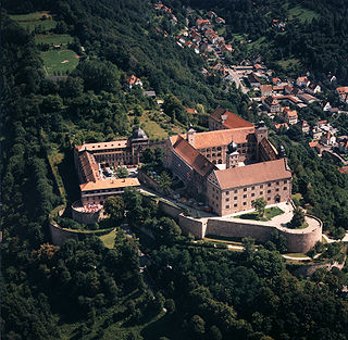
Plassenburg is a castle in the city of Kulmbach in Bavaria. It is one of the most impressive castles in Germany and a symbol of the city. It was first mentioned in 1135. The Plassenberg family were ministerial of the counts of Andechs and used as their seat the Plassenburg. The House of Guttenberg, a prominent Franconian noble family, traces its origins back to 1149 with a Gundeloh v. Blassenberg (Plassenberg). The name Guttenberg is derived from Guttenberg and was adopted by a Heinrich von Blassenberg around 1310. From 1340, the Hohenzollerns governed from Plassenburg castle their territories in Franconia till 1604. The Plassenburg was fortress and residence for the Hohenzollerns.

<span class="mw-page-title-main">Bad Staffelstein</span> Town in Bavaria, Germany

Bad Staffelstein is a small town in the Bavarian Administrative Region of Upper Franconia in Germany. It has around 10,000 inhabitants.

<span class="mw-page-title-main">Lichtenfels, Bavaria</span> Town in Bavaria, Germany

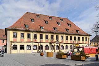
Lichtenfels is a town in the Upper Franconian region of Bavaria, Germany, the administrative seat of Lichtenfels district. It is chiefly known as the German "Basket City".

<span class="mw-page-title-main">Organisation Consul</span> German terrorist organization (1920–1922)

Organisation Consul (O.C.) was an ultra-nationalist and anti-Semitic terrorist organization that operated in the Weimar Republic from 1920 to 1922. It was formed by members of the disbanded Freikorps group Marine Brigade Ehrhardt and was responsible for political assassinations that had the ultimate goal of destroying the Republic and replacing it with a right-wing dictatorship. The group was banned by the German government in 1922.

<span class="mw-page-title-main">Duke Maximilian Joseph in Bavaria</span> German noble (1808–1888)

DukeMaximilian Joseph of Bavaria, known informally as Max in Bayern, was a member of a junior branch of the royal House of Wittelsbach who were Kings of Bavaria, and a promoter of Bavarian folk-music. He is most famous today as the father of Empress Elisabeth of Austria ("Sisi") and great-grandfather of King Leopold III of Belgium.

<span class="mw-page-title-main">Prince Alfons of Bavaria</span> German prince and military general (1862–1933)

Prince Alfons of Bavaria was a member of the Bavarian Royal House of Wittelsbach and a General of Cavalry.

<span class="mw-page-title-main">Prince Arnulf of Bavaria</span> German prince and military general (1852–1907)

Prince Arnulf of Bavaria was a member of the Bavarian Royal House of Wittelsbach and a General of Infantry.

Gerhard Stapelfeldt is a German sociologist. He was a university teacher at University of Hamburg until December 2010.

Tragelhöchstädt is a village in the municipality of Uehlfeld in the district of Neustadt (Aisch)-Bad Windsheim in Bavaria in Germany.

<span class="mw-page-title-main">Lichtenfels Forest</span> Forest in Bavaria, Germany

The Lichtenfels Forest is a forest northwest of the town of Lichtenfels in Upper Franconia in northern Bavaria, Germany.

<span class="mw-page-title-main">Rezatkreis</span>

The Rezatkreis, between 1806 and 1837, was one of the 15 districts of the Kingdom of Bavaria. Its name meant in German the “District of the Rezat” because the Fränkische Rezat River ran through it. It was the predecessor of the Regierungsbezirks Mittelfranken. Its center was Anspach.

<span class="mw-page-title-main">Free State of Coburg</span>

The Free State of Coburg emerged from the Duchy of Saxe-Coburg and Gotha at the end of the First World War. It existed from November 1918 until its union with the Free State of Bavaria on 1 July 1920.

<span class="mw-page-title-main">Höglwörth Abbey</span>

Höglwörth Abbey is a former monastery of the Augustinian Canons in Höglwörth, near Anger in Bavaria, in the Archdiocese of Munich and Freising.

Steinbach is a river of Bavaria, Germany.

<span class="mw-page-title-main">Creidlitz</span> Ortsteil of Coburg in Bavaria, Germany

Creidlitz is a southern suburb of 1705 inhabitants of the city of Coburg in the county of Upper Franconia in the state of Bavaria in Germany.

<span class="mw-page-title-main">Weinzierlein</span> Ortsteil of Zirndorf in Bavaria, Germany

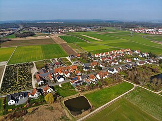
Weinzierlein is a village in the town of Zirndorf in the Central Franconian district of Fürth in Bavaria, Germany.

The Institute of Bavarian History at the Ludwig Maximilian University (Ludwig-Maximilians-Universität) in Munich is a centre of research and teaching of Bavarian history in a European context. It is located in the building complex of the Bavarian State Archives and in the immediate vicinity of the Bavarian State Library.

<span class="mw-page-title-main">Häusling (Erlangen)</span> Village in Middle Franconia, Bavaria

Häusling is a village in the city of Erlangen. Its resident population was 203 in 2020.

<span class="mw-page-title-main">Hütting</span> Part of Rennertshofen in Bavaria, Germany

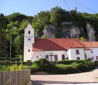
Hütting is a parish village, part of the market municipality of Rennertshofen, in the district of Neuburg-Schrobenhausen, in the region of Upper Bavaria, Germany.

References

  1. 1 2 "Aktuelle Einwohnerzahlen der Stadt Lichtenfels" (in German). Retrieved 24 September 2021.
  2. (de) Dr. Karl Friedrich Hohn, Atlas von Bayern: Geographisch-statistisch-historisches Handbuch zur Kenntnis des Zustandes von Bayern in seiner gegenwärtigen Beschaffenheit für alle Stände [Atlas of Bavaria: Geographical, Statistical and Historical Guide to the Knowledge of the State of Bavaria in Its Current Condition for All Classes] (Nürnberg: Verlag von Johann Adam Stein, 1840), p. 104
  3. (de) Rev. Dr. Joseph Anton Eisenmann and Prof. Dr. Karl Friedrich Hohn, Topo-geographisch-statistisches Lexicon vom Königreiche Bayern, Erster Band, A-E [Topographical-Geographical-Statistical Dictionary of the Kingdom of Bavaria, First Volume, A-E] (Erlangen: Johann Jacob Palm and Ernst Enke, 1831), p. 219
  4. (de) Prof. Wilhelm Götz, Geographisch-historisches handbuch von Bayern: II Band (Geographical-Historical Handbook of Bavaria: 2nd Volume), Munich, G. Franz'scher Verlag, 1898, page 183
  5. (de) Dr. E[rich]. Uetrecht (ed.), Meyers Orts– und Verkehrs-Lexikon des Deutschen Reichs, Band 1: A-K [Meyers Commercial Gazetteer of the German Empire, Volume 1: A-K], Leipzig, Biographisches Institut, 1912, pp. 257-258
  6. 1 2 (de) Buch am Forst auf der Webseite der Stadt Lichtenfels Archived 2016-03-04 at the Wayback Machine
  7. (de) Eisenmann and Hohn, Lexicon vom Königreiche Bayern, Erster Band, A-E, p. 219
  8. (de) Hohn, Atlas von Bayern, p. 104
  9. (de) Götz, Geographisch-historisches handbuch von Bayern: II Band page 183
  10. (de) Meyers Lexikon des Deutschen Reichs, pp. 257-258
  11. (de) Statistisches Bundesamt (Federal Bureau of Statistics), ed., Historisches Gemeindeverzeichnis für die Bundesrepublik Deutschland. Namens-, Grenz- und Schlüsselnummernänderungen bei Gemeinden, Kreisen und Regierungsbezirken vom 27. 5. 1970 bis 31. 12. 1982 [Historical Directory of the Municipalities of the Federal Republic of Germany. Name, Boundary and Key Number Changes for Communities, Districts and Administrations between 27 May 1970 and 31 December 1982]. Kohlhammer Verlag, Stuttgart and Mainz, 1983. ISBN   3-17-003263-1, p. 695
  12. (de) Matthias Simon: Historischer Atlas von Bayern, Kirchliche Organization, Erster Teil, Die Evangelische Kirche, Band 1 (Historical Atlas of Bavaria, Eccclesisastical Organization, First Series, The Evangelical Church, Volume 1). Munich, Kommission für bayerische Landesgeschichte (Commission of the Bavarian State History), pp. 226-227
  13. (de) http://www.dekanat-michelau.de/html/buch_am_forst.html Archived 2014-07-09 at the Wayback Machine
  14. (de) http://www.lichtenfels-city.de/index.php?id=495,32