Hoengseong County

Last updated
Hoengseong
횡성군
Korean transcription(s)
   Hangul 횡성군
   Hanja
  Revised RomanizationHoengseong-gun
  McCune-ReischauerHoengsŏng-gun
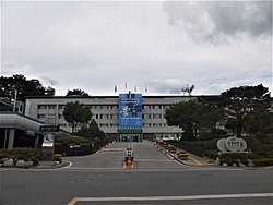
Hoengseong-gun Office.JPG
Hoengseong County Office
Flag of Hoengseong.svg
Gangwon-Hoengseong.svg
Location in South Korea
CountryFlag of South Korea.svg  South Korea
Region Gwandong
Administrative divisions 1 eup, 8 myeon
Area
  Total997.82 km2 (385.26 sq mi)
Population
 (2001)
  Total47,362
  Density47/km2 (120/sq mi)
  Dialect
Gangwon

Hoengseong County is a county located in southwestern Gangwon Province, South Korea, bordering Pyeongchang-gun to the east, Yangpyeong-gun, Gyeonggi-do to the west, Hongcheon-gun to the north, and Wonju-si and Yeongwol-gun to the south.

Contents

The roots of Codonopsis lanceolata (Korean : deodeok), a bonnet bellflower species, play an important role in local agriculture, as does Hanwoo beef, a specialty product.

The Korean Minjok Leadership Academy, a notable boarding school, is located in the county, an autonomous private high school that recruits students nationwide.

It may be confused with Hongseong-gun, Chungcheongnam-do because its name is similar.

Symbols

History

During the Goguryeo period (A.D. 413–475), it was called Hoengcheon-hyeon (橫川縣) or Eosamae (於斯買).[8] During the reign of King Gyeongdeok of Silla (AD 551), it was changed to Hwangcheonhyeon (潢川縣) and became the Yeonghyeon of Sakju (now Chuncheon). In the Goryeo Dynasty, it was changed to Hoengcheon again and subordinated to Sakju as before. Afterwards, it was made as a sub-hyeon of Wonju. In 1413 (13th year of King Taejong), Hyeongam was placed during the Joseon Dynasty, and Hoengcheon and Hongcheon were renamed Hoengseong in 1414 to avoid confusion due to the similar pronunciation.

Climate

Hoengseong has a monsoon-influenced humid continental climate (Köppen: Dwa) with cold, dry winters and hot, rainy summers. The climate reflects the location of the mountainous inland area of southwest. There is a wide seasonal difference in temperature. The highest temperature ever recorded in Hoengseong-gun was 37.0 °C (98.6 °F) on August 7, 1990 and the lowest was −29.8 °C (−21.6 °F) on December 31, 1927, and it was one of the five coldest temperatures ever recorded in Korea. [1]

Climate data for Hoengseong (1993–2020 normals)
MonthJanFebMarAprMayJunJulAugSepOctNovDecYear
Mean daily maximum °C (°F)2.3
(36.1)
5.8
(42.4)
12.3
(54.1)
19.5
(67.1)
24.9
(76.8)
28.7
(83.7)
29.7
(85.5)
30.4
(86.7)
26.2
(79.2)
20.4
(68.7)
12.1
(53.8)
4.0
(39.2)
18.0
(64.4)
Daily mean °C (°F)−4.3
(24.3)
−1.3
(29.7)
4.6
(40.3)
11.3
(52.3)
17.1
(62.8)
21.7
(71.1)
24.5
(76.1)
24.8
(76.6)
19.4
(66.9)
12.4
(54.3)
5.0
(41.0)
−2.4
(27.7)
11.1
(52.0)
Mean daily minimum °C (°F)−10.2
(13.6)
−7.3
(18.9)
−1.9
(28.6)
4.1
(39.4)
10.3
(50.5)
16.1
(61.0)
20.7
(69.3)
20.9
(69.6)
14.7
(58.5)
6.5
(43.7)
−0.6
(30.9)
−7.8
(18.0)
5.5
(41.9)
Average precipitation mm (inches)17.8
(0.70)
24.0
(0.94)
43.5
(1.71)
71.7
(2.82)
91.8
(3.61)
141.2
(5.56)
397.0
(15.63)
283.0
(11.14)
147.6
(5.81)
55.1
(2.17)
41.1
(1.62)
17.7
(0.70)
1,331.5
(52.42)
Average precipitation days (≥ 0.1 mm)4.24.26.67.77.88.814.513.38.15.06.74.891.7
Source: Korea Meteorological Administration [2]

Population

Hongseong's decline of population is the biggest matter among the county's residents and officers. The staggering decline has forced the educational system to close small schools (less than ten students per school) to close. Hoengseong county has established incentives for enrolling in the schools. [3]

Korean beef

Han-u, or Korean beef, from Hoengseong is widely sold and famous in South Korea. The clean environment of the region makes it possible to rear high-quality Korean beef. The muscles of the cattle are built up through labour in the fields. [4] Beef sets are delivered to department stores in Seoul and other metropolitan cities. Nowadays, improvements to transportation infrastructure have helped reduce the cost. [5] The county began a strategic marketing campaign in 1995 to brand itself as the origin of the highest quality beef in Korea. [4]

Recreational Areas

The Hoengseong area features large forested areas thanks to its location. More than four forest resorts are still in operation.

Forests are not completely natural, man-made forests are blended into existing natural forests. All kinds of wildlife, including roe deer, wild pigs, and rabbits, inhabit the forests. [6]

Wind farms

Schemes for building wind farms started in 2005 and allowed investors to complete the construction of a first complex in January 2008.

Hoengseong did install wind power plants after 2009. Construction was planned and executed by Japanese developer Eurus Energy and POSCO, installing about 20 plants around windy area. Total plant locations were divided between the counties of Hoengseong (9) and Pyeongchang (11), respectively. [7]

Sister cities

Famous people

Famous people born in Hoengseong County include Kim Heechul of Super Junior, and Lee Hyung-Taik.

See also

Deodeok muchim, a Korean salad made from C. lanceolata Dudok root and pine nut-c1.jpg
Deodeok muchim, a Korean salad made from C. lanceolata

Related Research Articles

<span class="mw-page-title-main">Gangwon Province, South Korea</span> Province of South Korea

Gangwon State is a Special Self-Governing Province of South Korea and the least densely populated subdivision of the country. Gangwon is one of the three provinces with special self-governing status, the others being Jeju Province and Jeonbuk State. On the east bound by the East Sea, it borders Gyeonggi Province to its west, North Gyeongsang Province and North Chungcheong Province to its south, and the Military Demarcation Line to the north, separating it from North Korea's Kangwŏn Province. Before the division of Korea in 1945 Gangwon and Kangwŏn Provinces formed a single province.

<span class="mw-page-title-main">South Chungcheong Province</span> Province of South Korea

South Chungcheong Province, also known as Chungnam, is a province of South Korea in the Hoseo region in the southwest of the Korean Peninsula. South Chungcheong borders the provinces of Gyeonggi to the north, North Chungcheong, Sejong Special Self-governing City, and Daejeon Metropolitan City to the east, and North Jeolla to the south.

<span class="mw-page-title-main">Pohang</span> Specific city in Yeongnam, South Korea

Pohang, formerly spelled Po-Hang, is the largest city in North Gyeongsang Province, South Korea, with a population of 499,363 as of 2022, bordering the East Sea to the east, Yeongcheon to the west, Gyeongju to the south, and Cheongsong and Yeongdeok to the north.

<span class="mw-page-title-main">Kangwon Province, North Korea</span> Province of North Korea

Kangwon Province is a province of North Korea, with its capital at Wŏnsan. Before the division of Korea in 1945, Kangwŏn Province and its South Korean neighbour Gangwon Province formed a single province that excluded Wŏnsan.

<span class="mw-page-title-main">Wonju</span> Municipal City in Gwandong, South Korea

Wonju is the most populous city in Gangwon Province, South Korea, with a population of 364,860 as of 2023. The city is located approximately 140 kilometres (87 mi) east of Seoul. During the time of Great Joseon, Wonju was the capital of the historic Gangwon Province, one of the Eight Provinces of Korea. It was the site of three crucial battles during the Korean War.

<span class="mw-page-title-main">Hongcheon County</span> County in Gwandong, South Korea

Hongcheon (Hongcheon-gun) is a county and city in Gangwon Province, South Korea. The city lies on the northern bank of the Hongcheon River, southeast of Chuncheon. The terrain of the county is mainly mountainous and contains hot springs in the Hongcheong River valley. The county produces ginseng, maize, and vegetables. As of 2012 the county had a population of 70,401 people in 29,894 households.

<span class="mw-page-title-main">Inje County</span> County in Gwandong, South Korea

Inje County is a county in Gangwon Province, South Korea. It has the lowest population density of any South Korean county. The county seat is Inje-eup, which located near the center of the county.

<span class="mw-page-title-main">Pyeongchang County</span> County in Gangwon-do, South Korea

Pyeongchang is a county in the province of Gangwon-do, South Korea, located in the Taebaek Mountains region. It is home to several Buddhist temples, including Woljeongsa. It is about 180 km (110 mi) east southeast of Seoul, the capital of South Korea, and connected by expressways and high-speed passenger railways. Pyeongchang's slogan, "Happy 700 Pyeongchang", is taken from its average elevation of approximately 700 metres (2,300 ft).

<span class="mw-page-title-main">Pocheon</span> Municipal City in Gyeonggi Province, South Korea

Pocheon (Korean pronunciation:[pʰo.tsʰʌn]) is an inland city in the far northeastern region of Gyeonggi province in South Korea. It covers 826.48 km (513.55 mi)2 with a population of 160,176 people, according to the 2008 census. Pocheon lies between Seoul and the mountainous northwestern areas of Gangwon province. The city borders Yeoncheon county, with the cities of Dongducheon and Yangju to the west, along with Uijeongbu, and Namyangju of Gyeonggi province to the south. It also borders Hwacheon county of Gangwon province on its eastern border and Cheorwon is to the north. Alongside the adjoining Gapyeong, Pocheon consists of the highest mountainous areas in Gyeonggi province. The current city of Pocheon was created after Pocheon-hyeon and Yeongpyeong counties were merged. The north part of the city used to be part of Yeongpyeong county while the south used to be part of Pocheon-hyeon.

<span class="mw-page-title-main">Seongnam</span> City in Gyeonggi, South Korea

Seongnam is the fourth largest city in South Korea's Gyeonggi Province after Suwon and the 10th largest city in the country. Its population is approximately one million. Seongnam is a satellite city of Seoul. It is largely a residential city located immediately southeast of Seoul and belongs to the Seoul Capital Area.

<span class="mw-page-title-main">Yeoju</span> Municipal city in Gyeonggi Province, South Korea

Yeoju is a city in Gyeonggi Province, South Korea. Yeoju was a county but was raised to the status of a city in September 2013. Together with the neighboring city of Icheon, it is known as a major center of contemporary South Korean ceramics, and hosts the World Ceramic Exposition every year. Other local products of note include rice, sweet potatoes, and yellow melons. Yeoju is the birthplace of Korea's last queen, Empress Myeongseong.

<span class="mw-page-title-main">Seosan</span> Municipal City in Chungcheong, South Korea

Seosan is a city in South Chungcheong Province, South Korea, with a population of roughly 175,000 according to the 2017 census. Located at the northwestern end of South Chungcheong Province, it is bounded by Dangjin City, Naepo New Town, Yesan-gun and Hongseong-gun on the east, Taean-gun and the Yellow Sea on the west, 125 km (78 mi) south of Seoul, 159 km (99 mi) northwest of Daejeon and 34 km (21 mi) northwest of Naepo New Town. Seosan is the hub of transportation of the west coast where the Seohaean Expressway, Daejeon-Dangjin Expressway, National Highways No. 29, 32, 38 and 45 intersect.

<span class="mw-page-title-main">Hadong County</span> County in Yeongnam, South Korea

Hadong County is a county in South Gyeongsang Province, South Korea. It is on the far-west side of the province, bordering South Jeolla Province. The county office is located at Hadeong-eup.

<span class="mw-page-title-main">Roman Catholic Diocese of Wonju</span> Roman Catholic diocese in South Korea

The Catholic Diocese of Wonju is a diocese of the Latin Church of the Catholic Church in located in Wonju, South Korea. It is a suffragan to the Archdiocese of Seoul.

<span class="mw-page-title-main">Guro District, Seoul</span> Autonomous District in Sudogwon, South Korea

Guro District (Guro-gu) is a district of Seoul, South Korea, which was separated from Yeongdeungpo District on April 1, 1980. Located in the southwestern part of the city, where besides Yangcheon District and Geumcheon District Guro District has an important position as a transport link which contains railroads, land routes from the rest of Seoul to the south of the country. The Gyeongbu and Gyeongin railway lines connect Seoul to Busan and Incheon. In addition, Seoul Metropolitan Subway lines 1, 2, and 7, and major highways intersect in Guro District.

Maehwasan is a South Korean mountain between Hoengseong County and Wonju, Gangwon-do. It has an elevation of 1,085 m (3,560 ft).

Siheung County, alternatively Shihŭng County was a county (gun) in Gyeonggi Province, South Korea. This county was abolished in 1989 as its one town(읍) of Sorae and two townships(면) of Gunja and Suam became Siheung City at the same time. Today's Siheung City area did not belong to Siheung County before 1914. The area rather was part of old Incheon or Ansan.

<span class="mw-page-title-main">Kōgen-dō</span> 1910–1945 province of Korea under Japan

Kōgen-dō, alternatively Kōgen Province, was a province of Korea under Japanese rule. Its capital was Shunsen (Chuncheon). The province corresponds to the combination of the modern Kangwon Province, North Korea and Gangwon Province, South Korea.
References

  1. Climate of Hoengseong official page
  2. "Climatological Normals of Korea (1991 ~ 2020)" (PDF) (in Korean). Korea Meteorological Administration. Archived from the original (PDF) on 29 January 2022. Retrieved 7 June 2023.
  3. http://www.kwnews.co.kr/view.asp?aid=208012300117&s=501 (kor)
  4. 1 2 "Archived copy". Archived from the original on 2012-04-02. Retrieved 2011-11-09.{{cite web}}: CS1 maint: archived copy as title (link)
  5. Department Store, Point on contents and price both. 백화점 '실속형' 선물세트 인기 Seoul Economy 2008.01.23
  6. Official page "Hoengseong-gun". Archived from the original on 2004-12-08. Retrieved 2008-01-26.
  7. Wind plants went live in March 2009 태기산 풍력발전단지 3월께 착공 http://www.kwnews.co.kr/view.asp?aid=208012000012&s=501
  8. "International Exchange". List of Affiliation Partners within Prefectures. Council of Local Authorities for International Relations (CLAIR). Archived from the original on 13 January 2016. Retrieved 21 November 2015.

37°29′23″N127°59′15″E / 37.4897222322°N 127.98750001°E / 37.4897222322; 127.98750001