Related Research Articles

Sauvie Island, in the U.S. state of Oregon, originally Wapato Island or Wappatoo Island, is the largest island along the Columbia River, at 26,000 acres (10,522 ha), and one of the largest river islands in the United States. It lies approximately ten miles northwest of downtown Portland, between the Columbia River to the east, the Multnomah Channel to the west, and the Willamette River to the south. A large portion of the island is designated as the Sauvie Island Wildlife Area. Sturgeon Lake, in the north central part of the island, is the most prominent water feature. The land area is 32.75 square miles (84.8 km2), or 20,959 acres (8,482 ha). Most of the island is in Multnomah County, but the northern third is in Columbia County. The Sauvie Island Bridge provides access across the Multnomah Channel from U.S. Route 30 and was completed in June 2008, replacing the first bridge to connect the island to the mainland which was opened on 30 December 1950.

Government Island is a 1,760-acre (710 ha) island in the Columbia River north of Portland, in Multnomah County, in the U.S. state of Oregon. Though Interstate 205 passes over it on the Glenn L. Jackson Memorial Bridge, access to the island is only by boat. There is a city controlled locked gate in the fence surrounding the freeway.
Sylvan-Highlands is a neighborhood of Portland, Oregon, United States located on the west side of the West Hills.

Tiller is an unincorporated community in Douglas County, Oregon, United States. It is located on Oregon Route 227 and the South Umpqua River, in the Umpqua National Forest.

Bull Run is an unincorporated community in Clackamas County, Oregon, United States. It is located about 5 miles northeast of Sandy, near the Bull Run River and the powerhouse of the defunct Mount Hood Railway and Power Company.

Blue Lake Regional Park is a public park in Fairview, in the U.S. state of Oregon. The 101-acre (41 ha) park, near the south shore of the Columbia River in Multnomah County, includes many covered and uncovered picnic areas, playing fields for sports such as softball, a cross country course and infrastructure related to lake recreation including swimming, boating, and fishing. Encompassing wooded areas, three ponds, and a wetland in addition to the lake, the park is frequented by migrating birds and other wildlife. Paved paths run through the park, which is near the 40-Mile Loop hiking and biking trail. Park vegetation includes cottonwoods, willows, and other trees and shrubs as well as wetland plants such as cattails.

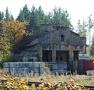
Cazadero is an unincorporated historic locale in Clackamas County, Oregon, United States. Cazadero was a station on the Estacada interurban railway line of the Portland Railway, Light and Power Company (PRL&P) and later Portland Electric Power Company (PEPCO), near where the power plant of the PEPCO-owned Cazadero Dam was located on the Clackamas River.
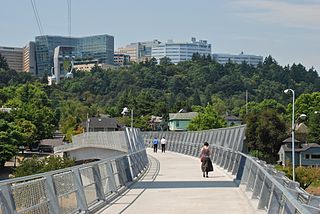
Marquam Hill is a populated hill located just south of Downtown Portland, Oregon, United States in the Homestead neighborhood. It is also called Pill Hill because it is home to Oregon Health & Science University, Portland VA Medical Center and Portland Shriners Hospital.
Tonquin is an unincorporated locale in Washington County, Oregon, United States.

Hauser is an unincorporated community in Coos County, Oregon, United States. It is along U.S. Route 101, 7 miles (11 km) south of Lakeside and 6 miles (10 km) north of North Bend. Hauser is on the edge of the Oregon Dunes National Recreation Area near North Slough, a tributary of Coos Bay once known as the North Inlet of Coos Bay. It is a station on the Central Oregon and Pacific Railroad.
Drew is an unincorporated community in Douglas County, Oregon, United States. It is located about six miles south of Tiller and 21 miles north of Trail on Oregon Route 227, surrounded by the Umpqua National Forest.
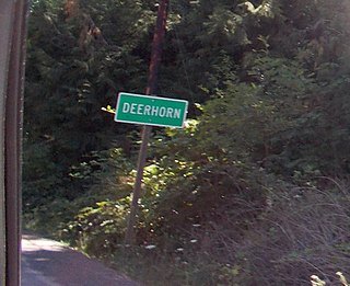
Deerhorn is an unincorporated community in Lane County, Oregon, United States. It is about 4 miles (6 km) west of Leaburg on Oregon Route 126 in the McKenzie River valley.
Carus is an unincorporated community in Clackamas County, Oregon, United States. It is located about seven miles south of Oregon City, on Oregon Route 213.
Pleasant Valley is an unincorporated community in Tillamook County, Oregon, United States. It is located about seven miles south of Tillamook, on U.S. Route 101.
Dodson is an unincorporated community in Multnomah County, Oregon, United States. It is located about 4½ miles (7.2 km) east of Multnomah Falls and one mile west of Warrendale, in the Columbia River Gorge on Interstate 84/U.S. Route 30. It is across the Columbia River from Skamania, Washington. Dodson is within the Cascade Locks ZIP code.

Warrendale is an unincorporated community in Multnomah County, Oregon, United States. It is located about a mile east of Dodson and about 3 miles (4.8 km) west of Bonneville in the Columbia River Gorge on Interstate 84/U.S. Route 30. It is across the Columbia River from Beacon Rock. The community was the site of an important salmon cannery founded in the 1870s.
Cascade Summit is an unincorporated community in Klamath County, Oregon, United States. It is located on the west shore of Odell Lake near Shelter Cove; about 30 miles southeast of Oakridge.
Firwood is an unincorporated community in Clackamas County, Oregon, United States. It is located about 3 miles southeast of Sandy just off U.S. Route 26. The junction of U.S. 26 and Firwood Road is known as Shortys Corner.
Burlington is an unincorporated community in Multnomah County, in the U.S. state of Oregon. It is located southeast of Holbrook on U.S. Route 30 near its intersection with Cornelius Pass Road.
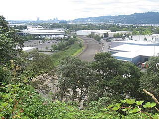
Mock's Bottom is a lowland northeast of Swan Island in Portland, Oregon, United States. It acquired its name from Henry Mock, who settled a donation land claim in the area with his family in 1852. Mock's Crest, named for Henry Mock's son John Mock, is a bluff that overlooks the lowland.
References
- 1 2 "Holbrook". Geographic Names Information System . United States Geological Survey. November 28, 1980. Retrieved August 2, 2011.
- ↑ Oregon Atlas & Gazetteer (7th ed.). Yarmouth, Maine: DeLorme. 2008. p. 22. ISBN 0-89933-347-8.
- 1 2 McArthur, Lewis A.; McArthur, Lewis L. (2003) [1928]. Oregon Geographic Names (7th ed.). Portland, Oregon: Oregon Historical Society Press. p. 472. ISBN 978-0875952772.
Coordinates: 45°39′35″N122°51′48″W / 45.659838°N 122.863436°W