Holland Road, London

Last updated

Holland Road, W14. Holland Road, London W14 - geograph.org.uk - 1292519.jpg
Holland Road, W14.

Holland Road is a road in Kensington, London, which connects Kensington High Street with the Holland Park roundabout. The southernmost section is one-way (northbound only, returning via Addison Road) and forms part of the Kensington/Earl's Court one-way system.

Contents

Location

The road forms part of the A3220. To the east is Addison Road and Holland Park. To the west is West Kensington and Kensington (Olympia) station. [1]

Etymology

Like Holland House and Holland Park, the road is named after the Earls and Barons Holland, who owned the estate on which the road was later built. [2]

Architecture

St John the Baptist Church on Holland Road. St John the Baptist Church, Holland Road, London W14 - geograph.org.uk - 1292622.jpg
St John the Baptist Church on Holland Road.

Holland Road is a prominent residential road situated in the district of Holland Park within the Royal Borough of Kensington and Chelsea. This partly tree lined boulevard runs roughly north - south and is characterised by its imposing period Victorian architecture. Most of the terraced town houses are 4 or 5 storeys high and feature either painted Italianate stucco or ornate brick facades and retain numerous original features. As with many such very large Kensington townhouses constructed in the 1870s, most of the houses have since been converted into spacious and sought after self-contained apartments. [3]

Part of the southern stretch of the road, between nos. 40 and 94, is also within the Royal Borough of Kensington and Chelsea's Holland conservation area. The architectural style adopted in construction is particularly notable and worthy of preservation because the terrace is essentially classical in its proportions, whilst being Gothic in its ornamentation. [4]

Public transport

Holland Road is especially well served by public transport (zone 2) with Holland Park, Shepherds Bush, Kensington (Olympia), and High Street Kensington train stations within easy walking distance as well as numerous bus routes passing along the road. [5] [6]

Residents past and present

100 Holland Road, a former residence of Freddie Mercury. Freddie Mercury's Former Home in Holland Road.jpg
100 Holland Road, a former residence of Freddie Mercury.

The greenery of Holland Park itself (the public park) is only a five-minute walk away to the east. Famous former residents include Freddie Mercury, the lead singer of the rock group Queen. He wrote the classic bestseller Bohemian Rhapsody whilst living at 100 Holland Road in the 1970s. The front cover from a record album is from a photo session of Queen taken at Mercury's flat in Holland Road. [7]

British solicitor John Indermaur lived at 114 Holland Road in the early twentieth-century. [8]

Until 2017, the corporate headquarters of Universal Music were located on the corner of Holland Road and Kensington High Street. [9]

Since 1962, the only showroom of Bristol Cars has been located on the corner of Holland Road and Kensington High Street. As a result of Bristol Cars' liquidation, the future of the showroom is unknown. [10] [11]

The Society of Science, Letters and Art, a late 19th century bogus learned society, had its headquarters at Addison House, 160 Holland Road (demolished). [12]

Related Research Articles

<span class="mw-page-title-main">Kensington</span> District within the Royal Borough of Kensington and Chelsea in central London

Kensington is an area of London in the Royal Borough of Kensington and Chelsea, around 2.9 miles (4.6 km) west of Central London.

<span class="mw-page-title-main">District line</span> London Underground line

The District line is a London Underground line running from Upminster in the east and Edgware Road in the west to Earl's Court in west London, where it splits into multiple branches. One branch runs to Wimbledon in south-west London and a short branch, with a limited service, only runs for one stop to Kensington (Olympia). The main route continues west from Earl's Court to Turnham Green after which it divides again into two western branches, to Richmond and Ealing Broadway.

<span class="mw-page-title-main">Royal Borough of Kensington and Chelsea</span> Royal borough in United Kingdom

The Royal Borough of Kensington and Chelsea is an Inner London borough with royal status. It is the smallest borough in London and the second smallest district in England; it is one of the most densely populated administrative regions in the United Kingdom. It includes affluent areas such as Notting Hill, Kensington, South Kensington, Chelsea, and Knightsbridge.

<span class="mw-page-title-main">Notting Hill</span> Area of London, England

Notting Hill is a district of West London, England, in the Royal Borough of Kensington and Chelsea. Notting Hill is known for being a cosmopolitan and multicultural neighbourhood, hosting the annual Notting Hill Carnival and Portobello Road Market. From around 1870, Notting Hill had an association with artists.

<span class="mw-page-title-main">Fulham</span> Area of west London, England

Fulham is an area of the London Borough of Hammersmith & Fulham in West London, England, 3.6 miles (5.8 km) southwest of Charing Cross. It lies on the north bank of the River Thames, bordering Hammersmith, Kensington and Chelsea. The area faces Wandsworth, Putney, Barn Elms and the London Wetland Centre in Barnes. on the far side of the river.

<span class="mw-page-title-main">Earl's Court tube station</span> London Underground station

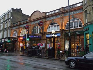
Earl's Court tube station is a Grade II listed London Underground station in Earl's Court, London, on the District and Piccadilly lines. It is an important interchange for both lines and is situated in both Travelcard Zone 1 and Zone 2. The station has an eastern entrance on Earl's Court Road and a western entrance on Warwick Road. Another former entrance allowed passengers to enter the station from the other side of Warwick Road, via a ticket hall and subway leading to a concourse beneath the District line platforms. Earl's Court is a step-free tube station; the Earls Court Road entrance provides lift access between street and platform levels.

<span class="mw-page-title-main">Sloane Square tube station</span> London Underground station

Sloane Square is a London Underground station in Chelsea, serving Sloane Square. It is served by the District and Circle lines, between South Kensington and Victoria stations and is in Travelcard Zone 1.

<span class="mw-page-title-main">St James's Park tube station</span> London Underground station

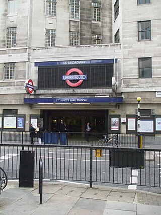
St James's Park is a London Underground station near St James's Park in the City of Westminster, central London. It is served by the District and Circle lines and is between Victoria and Westminster stations. It is in Travelcard Zone 1.

<span class="mw-page-title-main">Kensington High Street</span> Main shopping street in Kensington, London

Kensington High Street is the main shopping street in Kensington, London, England. The area is identified in the London Plan as one of 35 major centres in Greater London.

<span class="mw-page-title-main">Kensington (Olympia) station</span> London Underground and railway station

Kensington (Olympia) is a combined rail and tube station in Kensington, on the edge of Central London. Services are provided by London Overground, who manage the station, along with Southern and London Underground. It is in Travelcard Zone 2. On the Underground it is the terminus of a short District line branch from Earl's Court, originally built as part of the Middle Circle. On the main-line railway it is on the West London Line from Clapham Junction to Willesden Junction, by which trains bypass inner London. The station's name is drawn from its location in Kensington and the adjacent Olympia exhibition centre.

<span class="mw-page-title-main">Latimer Road tube station</span> London Underground station

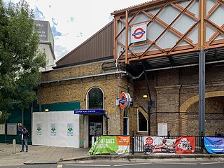
Latimer Road is a London Underground station in North Kensington, in the Royal Borough of Kensington and Chelsea. It is on the Circle and Hammersmith & City lines between Wood Lane and Ladbroke Grove stations and is in Travelcard Zone 2.

<span class="mw-page-title-main">Uxbridge Road tube station</span> Former London tube station

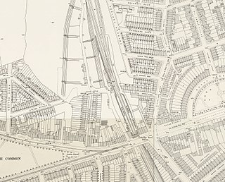
Uxbridge Road was a railway station on the West London Railway from 1869 to 1940. It was initially served by London & North Western Railway and the Great Western Railway. In 1905 the line became a branch of the Metropolitan Railway, and later London Underground's Metropolitan line. Uxbridge Road station closed on 21 October 1940 during World War II, when the West London Line was put out of service during the Blitz.

<span class="mw-page-title-main">West London line</span> Clapham Junction-Willesden Junction rail route

The West London line is a short railway in inner West London that links Clapham Junction in the south to Willesden Junction in the north. The line has always been an important cross-London link especially for freight services. Southern and London Overground provide regular passenger services; detailed below.

West Kensington, formerly North End, is an area in the ancient parish of Fulham, in the London Borough of Hammersmith and Fulham, England, 3.4 miles (5.5 km) west of Charing Cross. It covers most of the London postal area of W14, including the area around Barons Court tube station, and is defined as the area between Lillie Road and Hammersmith Road to the west, Fulham Palace Road to the south, Hammersmith to the north and West Brompton and Earl's Court to the east. The area is bisected by the major London artery the A4, locally known as the Talgarth Road. Its main local thoroughfare is the North End Road.

<span class="mw-page-title-main">West Brompton</span> Human settlement in England

West Brompton is an area of west London, that straddles the boundary between the London Borough of Hammersmith and Fulham and Royal Borough of Kensington and Chelsea. The centuries-old boundary was traced by Counter's Creek, now lost beneath the West London Line railway.

<span class="mw-page-title-main">London Buses route 9 (Heritage)</span> London heritage bus route

London Buses route 9 (Heritage) was a Transport for London contracted bus route in London that initially ran between the Royal Albert Hall and Aldwych before being extended from the Royal Albert Hall to Kensington High Street and shortened from Aldwych to Trafalgar Square. It was operated by First London and later Tower Transit with AEC Routemasters from November 2005 until July 2014.

The West London Railway was conceived to link the London and Birmingham Railway and the Great Western Railway with the Kensington Basin of the Kensington Canal, enabling access to and from London docks for the carriage of goods. It opened in 1844 but was not commercially successful.

<span class="mw-page-title-main">Brook Green</span> Human settlement in England

Brook Green is an affluent London neighbourhood in the London Borough of Hammersmith and Fulham. It is located approximately 3.6 miles (5.8 km) west of Charing Cross. It is bordered by Kensington, Holland Park, Shepherd's Bush, Hammersmith and Brackenbury Village.

<span class="mw-page-title-main">Addison Road, London</span> Street in the Royal Borough of Kensington and Chelsea

Addison Road is a road in London, England, which connects Kensington High Street with Notting Hill and Holland Park Avenue and runs nearby to Holland Park.

<span class="mw-page-title-main">Kahn Design</span>

Kahn Design is a British-based company that specialises in the modification of motor vehicles. Founded by Afzal Kahn, the company has its headquarters in Bradford and showrooms in both Chelsea and Kensington in London.

References

  1. Google map of Holland Road, Kensington Retrieved 10 February 2014
  2. Weinreb, Ben; Hibbert, Christopher (1992). The London Encyclopaedia (reprint ed.). Macmillan. p. 397.
  3. StreetView panorama of Holland Road Retrieved 10 February 2014
  4. British History Online: The Holland Estate to 1874 Retrieved 10 February 2014
  5. Transport for London: Holland Park Underground Station Retrieved 10 February 2014
  6. Transport for London: Kensington & Chelsea bus route maps Retrieved 10 February 2014
  7. West London Today: Freddie Mercury's rise to fame in traffic-polluted Holland Park flat Archived 22 February 2014 at the Wayback Machine Retrieved 10 February 2014
  8. "Royal Blue Book: Court and Parliamentary Guide". 1904.
  9. "Universal Music Moving UK Headquarters from Kensington to King's Cross". Billboard. 6 October 2015. Retrieved 13 April 2020.
  10. "Flashback: Bristol Cars, Kensington". Old Motors. 12 March 2020. Retrieved 13 April 2020.
  11. "Goodwood - GRR Unearths Bristol Treasure Beneath Kensington High Street". www.goodwood.com. Retrieved 13 April 2020.
  12. Evening Post, New Zealand, Volume XLV, Issue 132, 7 June 1893, p.2: A bogus literary society Retrieved 6 February 2014

Coordinates: 51°30′05″N0°12′45″W / 51.5015°N 0.21246°W / 51.5015; -0.21246