
Hedeby was an important Danish Viking Age trading settlement near the southern end of the Jutland Peninsula, now in the Schleswig-Flensburg district of Schleswig-Holstein, Germany. Around 965, chronicler Abraham ben Jacob visited Hedeby and described it as, "a very large city at the very end of the world's ocean."

Schleswig-Holstein is the northernmost of the 16 states of Germany, comprising most of the historical Duchy of Holstein and the southern part of the former Duchy of Schleswig. Its capital city is Kiel; other notable cities are Lübeck and Flensburg. It covers an area of 15,763 km2 (6,086 sq mi), making it the 5th smallest German federal state by area. Historically, the name can also refer to a larger region, containing both present-day Schleswig-Holstein and the former South Jutland County in Denmark.
Truso was a Viking Age port of trade (emporium) set up by the Scandinavians at the banks of the Nogat delta branch of the Vistula River, close to a bay, where it emptied into the shallow and brackish Vistula Lagoon. This sizeable lagoon is separated from the Gdańsk Bay by the Vistula Spit at the southern Baltic Sea coast. In the 9th century, the merchant Wulfstan of Hedeby travelled to Truso in the service of the English King Alfred the Great and wrote his account of the place at a prominent location of the Amber Road, which attracted merchants from central and southern Europe, who supplied the markets in the Mediterranean and the Middle East with the highly valued commodity.

The Duchy of Schleswig was a duchy in Southern Jutland covering the area between about 60 km north and 70 km (45 mi) south of the current border between Germany and Denmark. The territory has been divided between the two countries since 1920, with Northern Schleswig in Denmark and Southern Schleswig in Germany. The region is also called Sleswick in English.
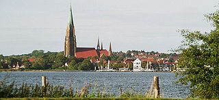
Schleswig is a town in the northeastern part of Schleswig-Holstein, Germany. It is the capital of the Kreis (district) Schleswig-Flensburg. It has a population of about 27,000, the main industries being leather and food processing. It takes its name from the Schlei (Slien), an inlet of the Baltic Sea at the end of which it sits, and vik or vig which means "bay" in Old Norse and Danish. Schleswig or Slesvig therefore means "bay of the Schlei".

The Schlei is a narrow inlet of the Baltic Sea in Schleswig-Holstein in northern Germany. It stretches for approximately 20 miles from the Baltic near Kappeln and Arnis to the city of Schleswig. Along the Schlei are many small bays and swamps. It separates the Angeln peninsula to the north from the Schwansen peninsula to the south.
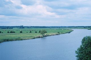
The Eider is the longest river in the German state of Schleswig-Holstein. The river starts near Bordesholm and reaches the southwestern outskirts of Kiel on the shores of the Baltic Sea, but flows to the west, ending in the North Sea. The lower part of the Eider was used as part of the Eider Canal until that canal was replaced by the modern Kiel Canal.

Angeln is a peninsula on the Baltic coast of Jutland, in the Bay of Kiel. It forms part of Southern Schleswig, the northernmost region of Germany. The peninsula is bounded on the north by the Flensburg Firth, which separates it from Sundeved and the island of Als in Denmark, and on the south by the Schlei, which separates it from Schwansen. The landscape is hilly, dotted with numerous lakes. The largest towns are Flensburg, Schleswig and Kappeln.

The Danish ethnic minority in Southern Schleswig, Germany, has existed by this name since 1920, when the Schleswig Plebiscite split German-ruled Schleswig into two parts: Northern Schleswig with a Danish majority and a German minority was united with Denmark, while Southern Schleswig remained a part of Germany and had a German majority and Danish and Frisian minority populations. Their historic roots go back to the beginning of Danish settlement after the emigration of the Angles. One of the most common names they use to describe themselves is danske sydslesvigere.

Oldenburg in Holstein is a German town at the southwestern shore of the Baltic Sea. The nearest city is Lübeck. The town belongs to the (historical) region of Holstein, today in the German state of Schleswig-Holstein.
The Danes were a North Germanic tribe inhabiting southern Scandinavia, including the area now comprising Denmark proper, northern and eastern England, and the Scanian provinces of modern-day southern Sweden, during the Nordic Iron Age and the Viking Age. They founded what became the Kingdom of Denmark. The name of their realm is believed to mean "Danish March", viz. "the march of the Danes", in Old Norse, referring to their southern border zone between the Eider and Schlei rivers, known as the Danevirke.

The Danevirke or Danework is a system of Danish fortifications in Schleswig-Holstein, Germany. This historically important linear defensive earthwork across the neck of the Cimbrian peninsula was initiated by the Danes in the Nordic Iron Age about AD 650. It was later expanded multiple times during Denmark's Viking Age and High Middle Ages. The Danevirke was last used for military purposes in 1864 during the Second War of Schleswig.

The Trave is a river in Schleswig-Holstein, Germany. It is approximately 124 kilometres (77 mi) long, running from its source near the village of Gießelrade in Ostholstein to Travemünde, where it flows into the Baltic Sea. It passes through Bad Segeberg, Bad Oldesloe, and Lübeck, where it is linked to the Elbe–Lübeck Canal. It is navigable for sea-going vessels from the Baltic to the Lübeck ports. The Herren Tunnel crosses the Trave, as do numerous bridges, and a ferry connects Travemünde with Priwall. Tributaries of the Trave include the Wakenitz and the Stepenitz.

The Treene is a river, hydrologically 95 km (59 mi) and nominally 73.4 km (45.6 mi) long, in Southern Schleswig in the north of Schleswig-Holstein, Germany. It is a right-bank tributary of the River Eider. It starts in northern Angeln, southeast of Flensburg, and flows mainly south-south-west before joining the Eider near Friedrichstadt.

Koldenbüttel is a municipality in the district of Nordfriesland, in Schleswig-Holstein, Germany.

Fahrdorf is a municipality in the district of Schleswig-Flensburg, in Schleswig-Holstein, Germany. It takes its name from the ferry that once crossed the Schlei here and today is shown in the town's coat of arms. Fahrdorf lies at the Bundesstraße 76 between the cities of Schleswig and Eckernförde. West of Fahrdorf lies the ancient Viking settlement of Hedeby.

The Rheider Au is a river of Schleswig-Holstein, Germany.

The Eider-Treene Depression is a landscape in west Schleswig-Holstein in North Germany. It covers 500 square kilometres (190 sq mi) around the rivers Eider, Treene and Sorge. The Eider-Treene Depression is the largest wetland in the German state of Schleswig-Holstein. It includes one third of the moorland (bog) in the state and is a habitat to the largest inland group of meadow birds. To the north, its border runs between Hollingstedt and Treia, to the east near Rendsburg, to the south the boggy depression reaches to the Hanerau and Haalerau beyond the Kiel Canal. Its western boundary with the Eiderstedt Marsh is unclear as marsh, bog and geest are interspersed. The region comprises the river valleys and their interfluvial geest ridges (Geestkernen). The landscape was formed during the ice ages, and altered by man as a result of dams and weirs built across the Eider, which was still a tidal river as far as Rendsburg until the 1920s. The region recently is encouraging "nature tourism" with walking, riding, cycling and canoe trips.

Tourism is an important economic factor for Germany's northernmost state of Schleswig-Holstein.
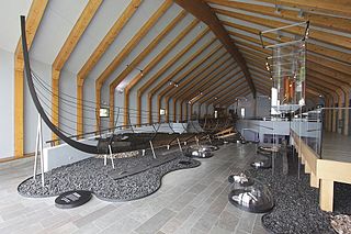
The Hedeby 1, also known as the Ship from Haithabu Harbour, was a Viking longship that was excavated from the harbor of Hedeby, a Viking trading center located near the southern end of the Jutland Peninsula, now in the Schleswig-Flensburg district of Schleswig-Holstein, Germany.


