Hopeville, Iowa | |
|---|---|
 Hopeville, Iowa | |
| Coordinates: 40°56′34″N93°59′48″W / 40.94278°N 93.99667°W | |
| Country | United States |
| State | Iowa |
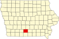
| County | Clarke |
| Elevation | 1,191 ft (363 m) |
| Time zone | UTC-6 (Central (CST)) |
| • Summer (DST) | UTC-5 (CDT) |
| Area code | 641 |
| GNIS feature ID | 457651 [1] |
Hopeville is an unincorporated community in Doyle Township, Clarke County, Iowa, United States. [1]