
McNary is a census-designated place (CDP) in Apache and Navajo counties in the U.S. state of Arizona, on the Fort Apache Indian Reservation. The population was 528 at the 2010 census. It is a 30-minute drive from Show Low and a 10-minute drive from Pinetop-Lakeside.

Globe is a city in Gila County, Arizona, United States. As of the 2020 census, the population of the city was 7,249. The city is the county seat of Gila County. Globe was founded c. 1875 as a mining camp. Mining, tourism, government and retirees are most important in the present-day Globe economy.

The Salt River is a river in Gila and Maricopa counties in Arizona, United States, that is the largest tributary of the Gila River. The river is about 200 miles (320 km) long. Its drainage basin covers about 13,700 square miles (35,000 km2). The longest of the Salt River's many tributaries is the 195-mile (314 km) Verde River. The Salt's headwaters tributaries, the Black River and East Fork, increase the river's total length to about 300 miles (480 km). The name Salt River comes from the river's course over large salt deposits shortly after the merging of the White and Black Rivers.

The Apache–Sitgreaves National Forests is a 2.76-million-acre (11,169 km2) United States National Forest which runs along the Mogollon Rim and the White Mountains in east-central Arizona and into the U.S. state of New Mexico. Formerly two forests, it is currently managed as one unit by USDA Forest Service from the Forest Supervisors Office in Springerville, Arizona. Apache–Sitgreaves has over 400 species of wildlife. With its high elevation and cool summer breezes it is a popular weekend destination from the hot desert for Phoenix, Arizona, residents. The forest is divided into 5 Ranger Districts that span almost 300 miles (480 km) from Clifton, Arizona in the east-central portion of Arizona to the eastern boundary of the Coconino National Forest in north-central Arizona. The Apache–Sitgreaves National Forest borders the western and northern borders of the Fort Apache Indian Reservation. It is located in parts of Greenlee, Apache, Navajo, and Coconino counties in eastern and east-central Arizona, and Catron County in western New Mexico. The more northwesterly Sitgreaves National Forest portion lies adjacent to the north side of the Fort Apache Indian Reservation and is located entirely in Arizona, within Navajo, Apache, and Coconino counties. It has a total area of 818,651 acres (3,313 km2). The more southeasterly and much larger Apache National Forest portion lies adjacent to the east side of the Fort Apache and the San Carlos Indian Reservations. It lies on both sides of the border with New Mexico, in Greenlee, Catron, and Apache counties. It has a total area of 1,813,601 acres (7,339 km2).

The Apache trout or Arizona trout, Oncorhynchus apache, is a species of freshwater fish in the salmon family of order Salmoniformes. It is one of the Pacific trouts.

Greer is an unincorporated community and census-designated place in Apache County, Arizona, United States. Located within the White Mountains of Arizona and surrounded by the Apache-Sitgreaves National Forest, Greer is the highest town in the state at an elevation of approximately 8,400 feet. As of the 2020 census it had a population of 58. Greer was founded circa 1879 by Mormon settlers from Utah. The Greer post office has the ZIP code of 85927.
Luna Lake is a natural body of water that covers approximately 75 acres (0.30 km2) of land. It is located about three miles (5 km) southeast of Alpine, Arizona, at the elevation of 7,890 ft (2,400 m), and is the centerpiece of the Luna Lake Wildlife Area.

San Carlos Lake was formed by the construction of the Coolidge Dam and is rimmed by 158 miles (254 km) of shoreline. The lake is located within the 3,000-square-mile (7,800 km2) San Carlos Apache Indian Reservation, and is thus subject to tribal regulations.

Mount Baldy is an extinct stratovolcano in eastern Arizona in the United States. With a summit elevation of 11,409 feet (3,477 m), the peak of Mount Baldy rises above the tree line and is left largely bare of vegetation, lending the mountain its current name. The Mount Baldy Wilderness occupies the eastern slope of the mountain and is managed by the Apache-Sitgreaves National Forest.
Hawley Lake is an American 300-acre (120 ha) lake and place in east-central Arizona, in the White Mountain Apache Indian Reservation, and has an elevation of 8,200 feet (2,500 m).

Woods Canyon Lake is a small lake located in northern Arizona, United States, about 30 mi (48 km) east of the city of Payson. It is one in a series of small, canyon-bound lakes located on the Mogollon Rim, collectively referred to as the Rim Lakes. It is among the more developed and accessible of the Rim Lakes. It is also the first reservoir on Chevelon Creek, upstream from Chevelon Canyon Lake.
Black Canyon Lake is a lake in Navajo County, Arizona, United States.

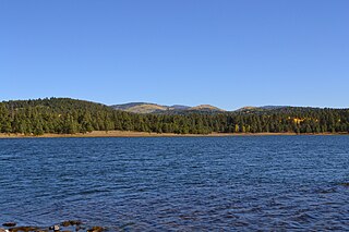
Big Lake is a reservoir in Arizona's White Mountains', with attractive size, recreational activities, and visitor amenities. As with most trout waters in Arizona, catch rates are best in spring, during late April and May after the winter ice thaws. Fishing gets even better later in the summer and into fall until the lake freezes over again in late November. Big Lake is in Apache County and is managed by the Apache-Sitgreaves National Forests.

The Black River is a 114-mile-long (183 km) river in the White Mountains of the U.S. state of Arizona. It forms south of the town of Greer and west of the towns of Nutrioso and Alpine. The river flows southwest then northwest to meet the White River west of Fort Apache. The merged streams form the Salt River, a major tributary of the Gila River. Both the Salt and Gila rivers supply water to the Phoenix metro area as well as provides water for farmland and crops around the valley.

Sugarite Canyon State Park is a state park of New Mexico, United States, featuring a historic early-20th century coal-mining camp and natural scenery at the border of the Rocky Mountains and the Great Plains. The park is located on the Colorado–New Mexico state line 6 miles (9.7 km) northeast of Raton, New Mexico.

Fort Apache is an unincorporated community in Navajo County, Arizona, United States. Fort Apache is on the Fort Apache Indian Reservation, 2 miles (3.2 km) east of Canyon Day. Fort Apache has a post office with ZIP code 85926.

The White Mountain Wilderness is a 46,963 acre designated wilderness area managed by the United States Forest Service. Located in the Smokey Bear Ranger District of the Lincoln National Forest, the White Mountain Wilderness lies in the Sierra Blanca mountains of south central New Mexico, approximately 15 miles (24 km) north northwest of the town of Ruidoso.

Willow Springs Lake is a cold water lake located on top of the Mogollon Rim in northern Arizona, about 23 mi (37 km) east of the city of Payson in the Apache-Sitgreaves National Forests, immediately adjacent to SR 260. It is a canyon-bound lake located on the Mogollon Rim, and is part of the collectivity known as the Rim Lakes. It can be found upstream from Chevelon Canyon Lake. The facilities are maintained by Apache-Sitgreaves National Forests division of the USDA Forest Service.
Earl Park Lake is a lake located in Apache County on the White Mountains Apache Indian Reservation in the White Mountains of Arizona. It is located 0.5 mi (0.80 km) south of Hawley Lake and 16.6 mi (26.7 km) from Whiteriver at an elevation of 8,251 ft (2,515 m). The lake is a reservoir on Earl Creek formed by Earl Park Dam with a surface area of 47 acres (19 ha). Fish varieties found include brook, rainbow, brown, and cutthroat trout.

Haigler Creek is an unincorporated community and census-designated place (CDP) in northern Gila County, Arizona, United States. It lies at an elevation of 5,240 feet and is surrounded by the Tonto National Forest. As of the 2020 census, Haigler Creek had a population of 39 people.


