Hosszúpályi

Last updated

Hosszúpályi
Large village
HUN Hosszupalyi Cimer.svg
Coat of arms
Country Flag of Hungary.svg  Hungary
County Hajdú-Bihar
District Derecske
Area
  Total69.47 km2 (26.82 sq mi)
Population (2015)
  Total5,662 [1]
  Density71.5/km2 (185/sq mi)
Time zone UTC+1 (CET)
  Summer (DST) UTC+2 (CEST)
Postal code 4274
Area code (+36) 52

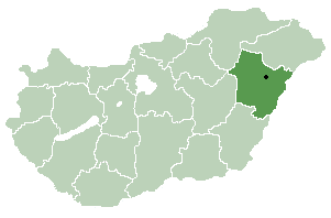
Hosszúpályi is a village in Hajdú-Bihar county, in the Northern Great Plain region of eastern Hungary.

Village Small clustered human settlement smaller than a town

A village is a clustered human settlement or community, larger than a hamlet but smaller than a town, with a population ranging from a few hundred to a few thousand. Though villages are often located in rural areas, the term urban village is also applied to certain urban neighborhoods. Villages are normally permanent, with fixed dwellings; however, transient villages can occur. Further, the dwellings of a village are fairly close to one another, not scattered broadly over the landscape, as a dispersed settlement.

Northern Great Plain Region in Hungary

The Northern Great Plain is a statistical region of Hungary. It is part of the Great Plain and North region. The Northern Great Plain includes the counties of Hajdú-Bihar, Jász-Nagykun-Szolnok, and Szabolcs-Szatmár-Bereg, with a total area of 17,749 km2 (6,853 sq mi) and a population of around 1.5 million.

In geography, regions are areas that are broadly divided by physical characteristics, human impact characteristics, and the interaction of humanity and the environment. Geographic regions and sub-regions are mostly described by their imprecisely defined, and sometimes transitory boundaries, except in human geography, where jurisdiction areas such as national borders are defined in law.

Contents

Geography

It covers an area of 69.47 km2 (27 sq mi) and has a population of 5662 people. [1] Much of the population is Roma [ citation needed ]. There is an elementary school, a police station, surgery and a dentist's office here. In the past agriculture was the main sector but it has been decreasing.

Area quantity that expresses the extent of a two-dimensional surface or shape, or planar lamina, in the plane

Area is the quantity that expresses the extent of a two-dimensional figure or shape, or planar lamina, in the plane. Surface area is its analog on the two-dimensional surface of a three-dimensional object. Area can be understood as the amount of material with a given thickness that would be necessary to fashion a model of the shape, or the amount of paint necessary to cover the surface with a single coat. It is the two-dimensional analog of the length of a curve or the volume of a solid.

Population All the organisms of a given species that live in the specified region

In biology, a population is all the organisms of the same group or species, which live in a particular geographical area, and have the capability of interbreeding. The area of a sexual population is the area where inter-breeding is potentially possible between any pair within the area, and where the probability of interbreeding is greater than the probability of cross-breeding with individuals from other areas.

Romani people ethnic group living mostly in Europe and the Americas

The Romani, colloquially known as Gypsies or Roma, are an Indo-Aryan ethnic group, traditionally itinerant, living mostly in Europe and the Americas and originating from the northern Indian subcontinent, from the Rajasthan, Haryana, and Punjab regions of modern-day India.

Related Research Articles

Hajdú-Bihar County Counties of Hungary in Northern Great Plain

Hajdú-Bihar is an administrative county in eastern Hungary, on the border with Romania. It shares borders with the Hungarian counties Szabolcs-Szatmár-Bereg, Borsod-Abaúj-Zemplén, Jász-Nagykun-Szolnok and Békés. The capital of Hajdú-Bihar county is Debrecen. Together with Bihor County in Romania it constitutes the Biharia Euroregion.

Viničky municipality of Slovakia

Viničky is a village and municipality in the Trebišov District in the Košice Region of south-eastern Slovakia.

Biharkeresztes Town in Hajdú-Bihar, Hungary

Biharkeresztes is a town in Hajdú-Bihar county, in the Northern Great Plain region of eastern Hungary.

Derecske Town in Hajdú-Bihar, Hungary

Derecske is a town in Hajdú-Bihar county, in the Northern Great Plain region of eastern Hungary.

Vekerd Place in Hajdú-Bihar, Hungary

Vekerd is a village in Hajdú-Bihar county, in the Northern Great Plain region of eastern Hungary.

Hajdúsámson Town in Hajdú-Bihar, Hungary

Hajdúsámson is a town in Hajdú-Bihar county, in the Northern Great Plain region of eastern Hungary. The current mayor is Hamza Gábor.

Létavértes Town in Hajdú-Bihar, Hungary

Létavértes or Leta Mare is a town in Hajdú-Bihar county, in the Northern Great Plain region of eastern Hungary.

Tiszacsege Town in Hajdú-Bihar, Hungary

Tiszacsege is a town in Hajdú-Bihar county, in the Northern Great Plain region of eastern Hungary.

Nagyrábé is a village in Hajdú-Bihar county, in the Northern Great Plain region of eastern Hungary.

Monostorpályi Place in Hajdú-Bihar, Hungary

Monostorpályi is a village in Hajdú-Bihar county, in the Northern Great Plain region of eastern Hungary.

Biri, Hungary Place in Szabolcs-Szatmár-Bereg, Hungary

Biri is a village in Szabolcs-Szatmár-Bereg county, in the Northern Great Plain region of eastern Hungary.

Bököny Place in Szabolcs-Szatmár-Bereg, Hungary

Bököny is a village in Szabolcs-Szatmár-Bereg county, in the Northern Great Plain region of eastern Hungary.

Napkor Place in Szabolcs-Szatmár-Bereg, Hungary

Napkor is a village in Szabolcs-Szatmár-Bereg county, in the Northern Great Plain region of eastern Hungary.

Tiszacsécse Place in Szabolcs-Szatmár-Bereg, Hungary

Tiszakanyár is a village in Szabolcs-Szatmár-Bereg county, in the Northern Great Plain region of eastern Hungary.

Szorgalmatos Place in Szabolcs-Szatmár-Bereg, Hungary

Szorgalmatos is a village in Szabolcs-Szatmár-Bereg county, in the Northern Great Plain region of eastern Hungary.

Geszteréd Place in Szabolcs-Szatmár-Bereg, Hungary

Geszteréd is a village in Szabolcs-Szatmár-Bereg county, in the Northern Great Plain region of eastern Hungary.

Kállósemjén Place in Szabolcs-Szatmár-Bereg, Hungary

Kállósemjén is a village in Szabolcs-Szatmár-Bereg county, in the Northern Great Plain region of eastern Hungary.

Kálmánháza Place in Szabolcs-Szatmár-Bereg, Hungary

Kálmánháza is a village in Szabolcs-Szatmár-Bereg county, in the Northern Great Plain region of eastern Hungary.

Nagycserkesz Place in Szabolcs-Szatmár-Bereg, Hungary

Nagycserkesz is a village in Szabolcs-Szatmár-Bereg county, in the Northern Great Plain region of eastern Hungary.

Nyírgelse Place in Szabolcs-Szatmár-Bereg, Hungary

Nyírgelse is a village in Szabolcs-Szatmár-Bereg county, in the Northern Great Plain region of eastern Hungary.

References

  1. 1 2 Gazetteer of Hungary, 1st January 2015 . Hungarian Central Statistical Office. 3 September 2015

Commons-logo.svg Media related to Hosszúpályi at Wikimedia Commons

Coordinates: 47°24′N21°45′E / 47.400°N 21.750°E / 47.400; 21.750

Geographic coordinate system Coordinate system

A geographic coordinate system is a coordinate system that enables every location on Earth to be specified by a set of numbers, letters or symbols. The coordinates are often chosen such that one of the numbers represents a vertical position and two or three of the numbers represent a horizontal position; alternatively, a geographic position may be expressed in a combined three-dimensional Cartesian vector. A common choice of coordinates is latitude, longitude and elevation. To specify a location on a plane requires a map projection.