Related Research Articles

The Pudding River is a 62-mile (100 km) tributary of the Molalla River in the U.S. state of Oregon. Its drainage basin covers 528 square miles (1,368 km2). Among its tributaries are Silver Creek, Butte Creek, Abiqua Creek, and the Little Pudding River.

Sauvie Island, in the U.S. state of Oregon, originally Wapato Island or Wappatoo Island, is the largest island along the Columbia River, at 26,000 acres (10,522 ha), and one of the largest river islands in the United States. It lies approximately ten miles northwest of downtown Portland, between the Columbia River to the east, the Multnomah Channel to the west, and the Willamette River to the south. A large portion of the island is designated as the Sauvie Island Wildlife Area. Sturgeon Lake, in the north central part of the island, is the most prominent water feature. The land area is 32.75 square miles (84.8 km2), or 20,959 acres (8,482 ha). Most of the island is in Multnomah County, but the northern third is in Columbia County. The Sauvie Island Bridge provides access across the Multnomah Channel from U.S. Route 30 and was completed in June 2008, replacing the first bridge to connect the island to the mainland which was opened on 30 December 1950.
Sylvan-Highlands is a neighborhood of Portland, Oregon, United States located on the west side of the West Hills.

Belknap Springs is an unincorporated community and private hot springs resort in Lane County, Oregon, United States, near the McKenzie River. The springs were located and initially developed by R. S. Belknap in 1869. A post office named "Salt Springs" was established in the location in 1874, and the name changed to "Belknap Springs" in 1875. The post office closed in 1877 and reopened in 1891, operating intermittently until 1953. Today the location uses a McKenzie Bridge mailing address.

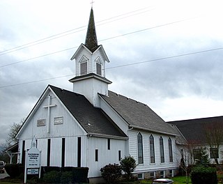
Pratum is an unincorporated community in Marion County, Oregon, United States. It is located northeast of Salem on Howell Prairie near the Pudding River. Pratum is Latin for "meadow". The community was settled in the late 19th century by a group of Mennonites, many of them of Swiss extraction. A branch of the narrow-gauge Oregonian Railway was built through the area in about 1880, and the station there was called "East Side Junction". The railway was eventually converted to standard gauge, and is still in use today by the Willamette Valley Railway. In 1895, the station was renamed "Enger" by a Mr. Larson, who opened the first store there. "Enger" was confused with Eugene, however, and the name of the station changed to "Pratum" in 1898. Pratum post office was established in 1887, and was originally called "Switzerland", then "Enger" and finally "Pratum" in 1898, matching the railroad station. The post office ran until 1964. Pratum School, built in 1928 and part of the Silver Falls School District, is still operating.

French Prairie is a prairie located in Marion County, Oregon, United States, in the Willamette Valley between the Willamette River and the Pudding River, north of Salem. It was named for some of the earliest settlers of that part of the Oregon Country, French Canadian/Métis people who were mostly former employees of the Hudson's Bay Company. French Prairie is also known as an early Métis settlement in the Pacific Northwest history.

Butte Creek is a stream in the U.S. state of Oregon, a tributary of the Pudding River. It is approximately 33 miles (53 km) long and, for all of its course, defines part of the northeastern boundary of Marion County and the southern boundary of Clackamas County.

Bull Run is an unincorporated community in Clackamas County, Oregon, United States. It is located about 5 miles northeast of Sandy, near the Bull Run River and the powerhouse of the defunct Mount Hood Railway and Power Company.
Thurston is a neighborhood in the eastern part of Springfield, Oregon, United States on Oregon Route 126. Before being annexed by Springfield, it was formerly an unincorporated community with its own post office. The earliest land claims in the Thurston area by white settlers were in 1851. A small crossroads community, including a general store and a blacksmith shop, formed at the corner of Thurston Road and 66th Street. The settlement was named for pioneer George H. Thurston, and Thurston post office was established in 1877. The ZIP code for Thurston post office boxes is 97482. The ZIP code for delivered mail is 97478.
Macksburg is an unincorporated community in Clackamas County, Oregon, United States four miles southeast of Canby. It is located on Gribble Prairie between the Pudding River and the Molalla River.
Salt Creek is an unincorporated historic community in Polk County, Oregon, United States on Oregon Route 22 about six miles northwest of Dallas. As an early European American settlement of the Oregon Country, the cemetery at Salt Creek has graves dating back to 1847. Salt Creek, a tributary of the South Yamhill River, was named by early settlers for the salt licks found on its banks. The Salt Creek post office, named after the creek, was established in 1852 and closed in 1903. James B. Riggs, who arrived in Oregon via the Oregon Trail and the Meek Cutoff in 1845, was the first postmaster. Riggs previously been the first postmaster of Yoncalla, followed by Jesse Applegate.
Shaw is an unincorporated community in Marion County, Oregon, United States, on Oregon Route 214.
Galena is an unincorporated community in Grant County, Oregon, United States, about 20 miles (32 km) from Austin Junction in the Blue Mountains. It is on the Middle Fork John Day River in the Malheur national forest. The former gold mining camp is considered a ghost town.
Macleay is an unincorporated community in Marion County, Oregon, United States, about nine miles east of downtown Salem in the Waldo Hills near the Little Pudding River.
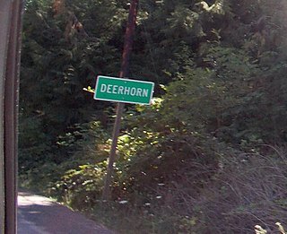
Deerhorn is an unincorporated community in Lane County, Oregon, United States. It is about 4 miles (6 km) west of Leaburg on Oregon Route 126 in the McKenzie River valley.
Willowcreek is an unincorporated community in Malheur County, Oregon, United States. It is about 11 miles (18 km) northwest of Vale on U.S. Route 26. The community has a store and café. Willowcreek is located at 44.114605°N 117.364349°W.

Bridge is an unincorporated community in Coos County, Oregon, United States. It is about 9 miles (14 km) east of Myrtle Point on Oregon Route 42 near the Middle Fork Coquille River.
Peel is an unincorporated community in Douglas County, Oregon, United States. It is located about six miles southeast of Glide near the Little River.
Thomas is a ghost town in Linn County, in the U.S. state of Oregon.
Wildwood is an unincorporated community in Lane County, Oregon, United States. It is located between Culp Creek and Disston on the former line of the Oregon, Pacific and Eastern Railway (OP&E), about 16 miles southeast of Cottage Grove.
References
- 1 2 3 4 McArthur, Lewis A.; Lewis L. McArthur (2003) [1928]. Oregon Geographic Names (Seventh ed.). Portland, Oregon: Oregon Historical Society Press. ISBN 0-87595-277-1.