
Hadleigh is an ancient market town and civil parish in South Suffolk, East Anglia, situated, next to the River Brett, between the larger towns of Sudbury and Ipswich. It had a population of 8,253 at the 2011 census. The headquarters of Babergh District Council were located in the town until 2017.

Eye is a market town and civil parish in the north of the English county of Suffolk, about 4 miles (6 km) south of Diss, 17.5 miles (28 km) north of Ipswich and 23 miles (37 km) south-west of Norwich. The population in the 2011 Census of 2,154 was estimated to be 2,361 in 2019. It lies close to the River Waveney, which forms the border with Norfolk, and on the River Dove. Eye is twinned with the town of Pouzauges in the Vendée department of France.
This article describes the history of Suffolk, the English county.

Costessey is a civil parish centred 4 miles (6.4 km) WNW of Norwich in Norfolk, England. Three centres of population exist: the long-established town/village of Costessey ; New Costessey of similar population, incepted in the first half of the 20th century, a long network of generally residential roads north of Dereham Road, contiguous with three smaller western suburbs of the county town (city); and Queens Hill which is green-buffered and which has a small country park, mature woodland and a large golf course adjoining. The parts named Old and New are separated by the Tud, adjoining fields and by a retail/business park in the west, a divide of about 2 miles (3.2 km). Old Costessey's northern limit is with Taverham, Drayton and Hellesdon, this follows the course of the wider river Wensum.
Hoxne is a village in the Mid Suffolk district of Suffolk, England, about five miles (8 km) east-southeast of Diss, Norfolk and 1⁄2 mile (800 m) south of the River Waveney. The parish is irregularly shaped, covering the villages of Hoxne, Cross Street and Heckfield Green, with a 'tongue' extending southwards to take in part of the former RAF Horham airfield.
Athelington is a small village and civil parish in the Mid Suffolk district of Suffolk, England, about 12 miles (19 km) south-east from Diss. The name is derived from the Old English word Ætheling. The population of the village was less than 50 at the 2011 Census and is included in the civil parish of Redlingfield, in 2005 the population was estimated as 30.
Barnardiston is a village and parish in the West Suffolk district of Suffolk, England. The village is located about four miles north-east of Haverhill off the A143.

Aldringham is a village in the Blything Hundred of Suffolk, England. The village is located 1 mile south of Leiston and 3 miles northwest of Aldeburgh close to the North Sea coast. The parish includes the coastal village of Thorpeness. The mid-2005 population estimate for Aldringham cum Thorpe parish was 730.

Sir Clement Higham, or Heigham, of Barrow, Suffolk, was an English lawyer and politician, a Speaker of the House of Commons in 1554, and Chief Baron of the Exchequer in 1558–1559. A loyal Roman Catholic, he held various offices and commissions under Queen Mary, and was knighted in 1555 by King Philip, but withdrew from politics after the succession of Queen Elizabeth I in 1558.
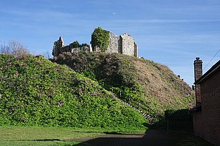
Eye Castle is a motte and bailey medieval castle with a prominent Victorian addition in the town of Eye, Suffolk. Built shortly after the Norman conquest of England in 1066, the castle was sacked and largely destroyed in 1265. Sir Edward Kerrison built a stone house on the motte in 1844: the house later decayed into ruin, becoming known as Kerrison's Folly in subsequent years.
The high sheriff is the oldest secular office under the Crown and is appointed annually by the Crown. The High Sheriff of Norfolk was originally the principal law enforcement officer in Norfolk and presided at the assizes and other important county meetings. Most of the responsibilities associated with the post have been transferred elsewhere or are now defunct, so that its functions are now largely ceremonial. There was a single high sheriff serving the two counties of Norfolk and Suffolk until 1576.

Sisland, historically Sislanda, is a very small village, manor and parish in the county of Norfolk, England, about a mile west of Loddon. In the 2001 census, the population was 44 in 16 households. The parish covers an area of 1.90 km2 (0.73 sq mi), and is approximately 9.3 miles (15.0 km) southeast of Norwich and 12.7 miles (20.4 km) west of Great Yarmouth. For the purposes of local government, it falls within the district of South Norfolk, however it does not have its own Parish Council. The village contains only one heritage-listed building, that being St Mary's Church, which is Grade II*.
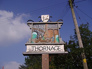
Thornage is a village and a civil parish in the English county of Norfolk. The village is 2.7 miles south-west of Holt, 23.2 miles north-west of Norwich and 11.3 miles east of Fakenham, and straddles the B1110 road between Holt and Guist. The nearest railway station is at Sheringham for the Bittern Line which runs between Sheringham, Cromer and Norwich. The nearest airport is at Norwich International Airport.

Thorpe Morieux is a small village and civil parish in Suffolk, England. It is 10 miles south-east of Bury St Edmunds and 10 miles north east of Sudbury.

General Sir Edward Kerrison, 1st Baronet, was a British Army officer and politician.
Hoxne was a hundred of Suffolk, with an area of 55,648 acres (225.20 km2).

St Cross South Elmham is a village and civil parish in the north of the English county of Suffolk. It is in the East Suffolk district, close to the border with Norfolk and is 3 miles (4.8 km) east of Harleston and 4.25 miles (6.84 km) south-west of Bungay. It is one of the villages around Bungay known as the Saints.

Chickering is a place in the civil parish of Hoxne, and the Mid Suffolk district of Suffolk, England. It is on the B118 Hoxne to Stradbroke road, and approximately 20 miles (30 km) north from the county town of Ipswich.

St Edmund's Memorial, Hoxne is a memorial which claims to mark the spot where St Edmund was killed by the Vikings in the Suffolk village of Hoxne. The monument is a Grade II listed building located in a field 95m east of Abbey Hill. The monument refers to an oak tree which fell under its own weight in the mid nineteenth century.
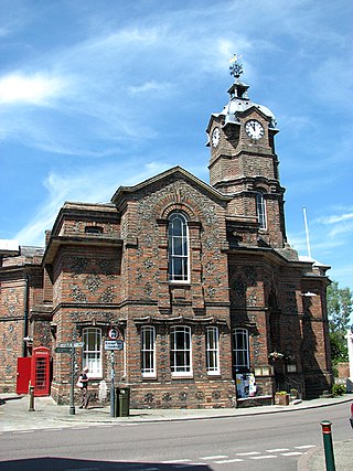
Eye Town Hall is a municipal building in Broad Street in Eye, Suffolk, England. The building, which is the meeting place of Eye Town Council, is a Grade II* listed building.
