
The Hoh River is a river of the Pacific Northwest, located on the Olympic Peninsula in the U.S. state of Washington. About 56 miles (90 km) long, the Hoh River originates at the snout of Hoh Glacier on Mount Olympus and flows westward through the Olympic Mountains of Olympic National Park and Olympic National Forest, then through foothills in a broad valley, emptying into the Pacific Ocean at the Hoh Indian Reservation. The final portion of the Hoh River's course marks the boundary between the south coastal segment of Olympic National Park and the Hoh Indian Reservation.
The Britannia Range is a range of mountains bounded by the Hatherton Glacier and Darwin Glacier on the north and the Byrd Glacier on the south, westward of the Ross Ice Shelf in Antarctica.
The Cook Mountains is a group of mountains bounded by the Mulock and Darwin glaciers in Antarctica. They are south of the Worcester Range and north of the Darwin Mountains and the Britannia Range.

The Darwin Glacier is a large glacier in Antarctica. It flows from the polar plateau eastward between the Darwin Mountains and the Cook Mountains to the Ross Ice Shelf. The Darwin and its major tributary the Hatherton are often treated as one system, the Darwin–Hatherton.
The Darwin Mountains are a group of mountains between the Darwin Glacier and Hatherton Glacier in Antarctica. They were discovered by the British National Antarctic Expedition (1901–04) and named for Major Leonard Darwin, at that time Honorary Secretary of the Royal Geographical Society. They are south of the Cook Mountains and north of the Britannia Range

The Wright Valley is a large east–west trending valley, formerly occupied by a glacier but now ice free except for Wright Upper Glacier at its head and Wright Lower Glacier at its mouth, in Victoria Land, Antarctica. It was named by the VUWAE (1958-59) for Sir Charles Wright, for whom the BrAE (1910-13) named the glacier at the mouth of this valley.
Mount McClintock is the highest mountain in the Britannia Range in Antarctica, surmounting the south end of Forbes Ridge, 6 nautical miles east of Mount Olympus.

The Asgard Range is a mountain range in Victoria Land, Antarctica. It divides Wright Valley from Taylor Glacier and Taylor Valley. It is south of the Olympus Range and north of the Quartermain Mountains and the Kukri Hills.
Crescent Glacier is located on the southeast slopes of Mount Adams in the U.S. state of Washington in Gifford Pinchot National Forest. A small subpeak of Mount Adams, named South Butte, rises nearby. Crescent Glacier is close to the Gotchen Glacier which is located just to the east. Crescent Glacier lies in a small south-facing cirque with a steep headwall. The glacier ranges in elevation from 8,400 ft (2,600 m) at the foot of the steep cliff to 7,900 ft (2,400 m) at the moraine. One arm of the glacier extends south down to 7,600 ft (2,300 m). Between 1904 and 2006, Crescent Glacier lost 6 percent of its surface area.
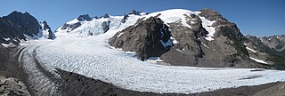
Blue Glacier is a large glacier located to the north of Mount Olympus in the Olympic Mountains of Washington. The glacier covers an area of 1.7 sq mi (4.4 km2) and contains 580,000,000 cu ft (16,000,000 m3) of ice and snow in spite of its low terminus elevation. The glacier length has decreased from about 3.4 mi (5.5 km) in 1800 to 2.7 mi (4.3 km) in the year 2000. Just in the period from 1995 and 2006, Blue Glacier retreated 325 ft (99 m). Blue Glacier is also thinning as it retreats and between 1987 and 2009 the glacier lost 178 ft (54 m) of its depth near its terminus and between 32 and 48 ft in the uppermost sections of the glacier known as the accumulation zone.
Harrower Glacier is located on the west side of the Continental Divide in the northern Wind River Range in the US state of Wyoming. The glacier is in the Bridger Wilderness of Bridger-Teton National Forest, and is among the largest grouping of glaciers in the American Rocky Mountains. Harrower Glacier flows to the north and is situated in a cirque, below the summit of Knife Point Mountain.

White Glacier is located on the north slopes of Mount Tom in the Olympic Mountains and Olympic National Park in the U.S. state of Washington. The main portion of the glacier heads at around 7,000 and 6,400 feet in a cirque just under the summit rocks, while the westernmost section of White Glacier is partially separated from the rest of the glacier by several small ridges of rock and flows straight north. The principle portion of the glacier flows north as well, with a glacier toe descending to around 4,800 feet (1,500 m) where the toe turns northeast to its terminus at 4,400 feet (1,300 m). Steep ridges of rock separate an eastern portion of the White Glacier from the Blue Glacier cirque on adjacent Mount Olympus, to the east.

Anderson Glacier was a glacier located in a cirque south of Mount Anderson in the Olympic Mountains and Olympic National Park. The southward-facing glacier starts on the steep headwalls of the cirque at about 6,200 feet (1,900 m) to 6,000 ft (1,800 m). It flows down to about 5,240 ft (1,600 m) before terminating. Meltwater from the glacier enters a lake at about 4,949 ft (1,508 m) before tumbling down a steep cliff. Between 1927 and 2009, Anderson Glacier lost more than 90 percent of its surface area. By 2011, the glacier was gone. The lack of glacial meltwater from the Anderson Glacier has caused the Quinault River to reach new recorded lows.
Eel Glacier is located to the north of Mount Anderson and east of West Peak, in Olympic National Park in the U.S. state of Washington. The northward-facing glacier starts at about 6,600 feet (2,000 m) in elevation, with an arm extending up to 7,100 ft (2,200 m). As the glacier flows north, it descends in elevation to about 5,200 ft (1,600 m) at its terminus. Meltwater from the glacier gives rise to Silt Creek, which flows through the Olympic Mountains and Olympic National Park. Between 1920 and 2009, Eel Glacier has retreated significantly, losing 50 percent of its surface area.
Ice River Glacier is located 2.4 miles (3.9 km) northeast of Mount Olympus in the Olympic Mountains of Olympic National Park in the U.S. state of Washington. Starting at an elevation of 6,400 feet (2,000 m) on the northern slope of a subpeak of Mount Olympus known as Mercury, the glacier flows northwest as it descends. The glacier reaches as low as 5,200 ft (1,600 m) before terminating. Though the glacier lies adjacent to the much larger Blue Glacier, an arête separates the two glaciers.

The Cameron Glaciers are several ice bodies located on Mount Cameron in the Olympic Mountains in Olympic National Park. These glaciers are located in four north to northeast-facing cirques and range in elevation from about 6,700 feet (2,000 m) to just under 6,000 ft (1,800 m). The ice bodies in the easternmost, northeast-oriented cirque are the smallest, while the glacier just to the west is the largest. The westernmost two ice bodies are roughly equal in surface area. All bodies of ice located in these cirques are separated by arêtes. Meltwater from the glacier eventually enters Cameron Creek located to the north.
Jeffers Glacier is southeast of Mount Olympus in the Olympic Mountains in Olympic National Park, Washington, US. The glacier is relatively small compared to the nearby Hoh Glacier. Beginning at the foot of a very steep headwall at about 5,800 feet (1,800 m), the glacier descends northeast to about 4,900 ft (1,500 m) before terminating. Meltwater from the terminus flows to the Queets River.
The Land Glacier is a broad, heavily crevassed glacier, about 35 nautical miles long, descending into Land Bay in Marie Byrd Land, Antarctica. It was discovered by the United States Antarctic Service (1939–41) and named for Rear Admiral Emory S. Land, Chairman of the United States Maritime Commission.
The Olympus Range is a primarily ice-free mountain range of Victoria Land, Antarctica, with peaks over 2,000 metres (6,600 ft) high, between Victoria Valley and McKelvey Valley on the north and Wright Valley on the south. It is south of the Clare Range and north of the Asgard Range.

Humes Glacier is located in the Olympic Mountains in Olympic National Park, approximately 2.25 miles (3.62 km) southeast of the summit of Mount Olympus. The glacier starts at nearly 6,000 ft (1,800 m) and descends downslope 1.25 mi (2.01 km), terminating at 4,800 ft (1,500 m) above sea level.

