
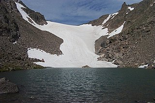
Tyndall Glacier is a small cirque glacier in Rocky Mountain National Park in the U.S. state of Colorado. Tyndall Glacier is on the east side of the Continental Divide and in a cirque to the north of Hallett Peak. Tyndall Glacier is both an ice and a rock glacier, with the lower portions of the glacier being composed primarily of rock debris and a small portion of ice.
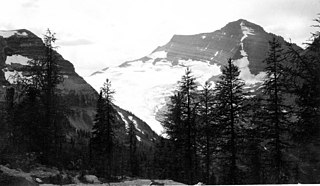
Andrews Glacier is an alpine glacier in a cirque below Otis Peak in Rocky Mountain National Park in the U.S. state of Colorado. The glacier extends from Andrews Pass at nearly 12,000 to 11,700 feet with some perennial snow extending to Andrews Tarn, a small proglacial lake. When images of the glacier taken in the early 1900s are compared with those of the early 2000s, Andrews Glacier is showing a negative glacier mass balance which indicates the glacier is retreating.
Agassiz Glacier is in Glacier National Park in the U.S. state of Montana. It is named after Louis Agassiz, a Swiss-American glaciologist. The glacier is situated in a cirque to the southeast of Kintla Peak west of the Continental Divide. Agassiz Glacier is one of several glaciers that have been selected for monitoring by the U.S. Geological Survey's Glacier Monitoring Research program, which is researching changes to the mass balance of glaciers in and surrounding Glacier National Park.

Boulder Glacier is located in the U.S. state of Montana in Glacier National Park (U.S.). The glacier is situated to the north of Boulder Peak and west of the Continental Divide. Between 1966 and 2005, Boulder Glacier lost more than 75 percent of its surface area. As of 2005 the glacier was measured to cover only 13 acres (0.053 km2), and no longer met the 25 acres (0.10 km2) threshold often cited as the minimal area to qualify as an active glacier.
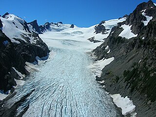
Eel Glacier is located to the north of Mount Anderson and east of West Peak, in Olympic National Park in the U.S. state of Washington. The northward-facing glacier starts at about 6,600 feet (2,000 m) in elevation, with an arm extending up to 7,100 ft (2,200 m). As the glacier flows north, it descends in elevation to about 5,200 ft (1,600 m) at its terminus. Meltwater from the glacier gives rise to Silt Creek, which flows through the Olympic Mountains and Olympic National Park. Between 1920 and 2009, Eel Glacier has retreated significantly, losing 50 percent of its surface area.
Hanging Glacier is a located northeast of Mount Anderson in the Olympic Mountains and Olympic National Park, U.S. state of Washington. The glacier starts north of a saddle between Mount Anderson and East Peak at about 5,700 feet (1,700 m). Like all the glaciers in Olympic National Park, Hanging Glacier is in a state of retreat.

The Cameron Glaciers are several ice bodies located on Mount Cameron in the Olympic Mountains in Olympic National Park. These glaciers are located in four north to northeast-facing cirques and range in elevation from about 6,700 feet (2,000 m) to just under 6,000 ft (1,800 m). The ice bodies in the easternmost, northeast-oriented cirque are the smallest, while the glacier just to the west is the largest. The westernmost two ice bodies are roughly equal in surface area. All bodies of ice located in these cirques are separated by arêtes. Meltwater from the glacier eventually enters Cameron Creek located to the north.

Shepard Glacier is a glacier remnant (glacieret) In Glacier National Park in the U.S. state of Montana. The glacieret is immediately southeast of Cathedral Peak. Shepard Glacier was one of a number of glaciers that have been documented by the United States Geological Service (USGS) to have retreated significantly in Glacier National Park. Shepard Glacier was measured in 2009 to have decreased to less than 25 acres (0.10 km2), considered to be a minimal size to qualify as being considered an active glacier. Between 1966 and 2005, Shepard Glacier lost 56 percent of its surface area.

Red Eagle Glacier is a glacier remnant (glacieret) in Glacier National Park in the U.S. state of Montana. The glacieret is a hanging glacier located on the north slope of Clyde Peak, and to the southeast of Mount Logan and Logan Glacier. Between 1966 and 2005, Red Eagle Glacier lost 53 percent of its surface area and now covers less than 25 acres (0.10 km2) which is below the threshold to qualify as an active glacier. Comparing images of the glacier taken in 1914 with those from 2009, indicates that the glacier has experienced extensive retreat.
Baby Glacier is a glacier located in the U.S. state of Montana in Glacier National Park. Baby Glacier is situated in a cirque on the northeast slope of Numa Peak at an elevation between 7,200 feet (2,200 m) and 6,800 feet (2,100 m) above sea level. The glacier covers approximately 19 acres (0.077 km2) and does not meet the threshold of 25 acres (0.10 km2) often cited as being the minimum size to qualify as an active glacier. Between 1966 and 2005, Baby Glacier lost a third of its surface area.
The Carter Glaciers are in Glacier National Park in the U.S. state of Montana. The glaciers are situated along a ridge immediately to the east of the Continental Divide, mainly below an unnamed peak which rises to 9,164 feet (2,793 m). The glaciers cover an area of approximately 50 acres (0.20 km2) at an elevation between 8,500 feet (2,600 m) and 7,200 feet (2,200 m) above sea level. The Carter Glaciers consist of between three and four separate small glacial remnants (glacierets), none of which meet the threshold of 25 acres (0.10 km2) often cited as being the minimum size to qualify as an active glacier.
Harris Glacier is located in the US state of Montana in Glacier National Park. The glacier is situated in a cirque immediately to the northeast of Parke Peak at an elevation between 7,000 ft (2,100 m) and 6,600 ft (2,000 m) above sea level. The glacier covers an area of approximately 8 acres (0.032 km2) and does not meet the threshold of 25 acres (0.10 km2) often cited as being the minimum size to qualify as an active glacier. Between 1966 and 2005, the glacier lost 77 percent of its acreage.
Sexton Glacier is located in the U.S. state of Montana in Glacier National Park. The glacier is situated in a cirque north of Going-to-the-Sun Mountain and on the southeast slope of Matahpi Peak at an elevation between 8,000 feet (2,400 m) and 7,000 feet (2,100 m) above sea level. The glacier covers an area of approximately 68 acres (0.28 km2) and lost over 30 percent of its surface area between 1966 and 2005.

Two Ocean Glacier is in Glacier National Park in the U.S. state of Montana. The glacier is situated on the west side Continental Divide below Vulture Peak at an average elevation of 8,400 feet (2,600 m) above sea level. As of 2005, Two Ocean Glacier consisted of numerous ice patches covering a total of 67 acres (0.27 km2) and is more than 35 percent smaller than it was in 1966.
Vulture Glacier is in Glacier National Park, U.S. state of Montana. The glacier is situated just south of Vulture Peak at an average elevation of 8,412 feet (2,564 m) above sea level. Between 1966 and 2005, Vulture Glacier lost over 50 percent of its surface area.
Hoh Glacier is a glacier on Mount Olympus in the Olympic National Park in Jefferson County of the U.S. state of Washington. It is the source of the Hoh River. Hoh Glacier is the longest glacier on Mount Olympus at 3.06 miles (4.93 km), though it is smaller in volume than Blue Glacier.
Taylor Glacier is a small cirque glacier in Rocky Mountain National Park in the U.S. state of Colorado. Taylor Glacier is on the east side of the Continental Divide and adjacent to Taylor Peak. Taylor Glacier is both an ice and a rock glacier, with the lower portions of the glacier being composed primarily of rock debris and a small portion of ice.
The Dove is a small cirque glacier or perennial snowfield located in Rocky Mountain National Park in the U.S. state of Colorado. The Dove is on the north slope of Longs Peak and near The Keyhole, which is along a popular climbing route to the summit.
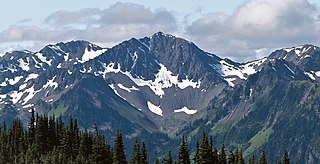
McCartney Peak is a 6,784-foot-elevation (2,068-meter) mountain summit located within Olympic National Park in Jefferson County of Washington state. Part of the Olympic Mountains, McCartney Peak is situated 18 miles south of Port Angeles, and set within the Daniel J. Evans Wilderness. Topographic relief is significant as the southwest aspect rises 3,800 feet above the Lost River in approximately 1.5 mile. Precipitation runoff from the mountain drains north into headwaters of the Lillian River, east to the Gray Wolf River via Cameron Creek, and west to the Elwha River via Lost River. The nearest higher neighbor is line parent Mount Cameron, 3.1 mi (5.0 km) to the southeast.

