
The Cadomin Formation is a stratigraphic unit of Early Cretaceous age in the western part of the Western Canada Sedimentary Basin. It is extends from southeastern British Columbia through western Alberta to northeastern British Columbia, and it contains significant reservoirs of natural gas in some areas. It was named after the mining town of Cadomin, which is an acronym of "Canadian Dominion Mining".
Gething Formation is a stratigraphic unit of Lower Cretaceous (Aptian) age in the Western Canada Sedimentary Basin. It is present in northeastern British Columbia and western Alberta, and includes economically important coal deposits.
Bullhead Group is a stratigraphic unit of Lower Cretaceous age in the Western Canada Sedimentary Basin of northeastern British Columbia and western Alberta. It was first defined by F.H. McLearn in 1918 as the Bullhead Mountain Formation, but later was upgraded to group status. It consists of the Cadomin and Gething Formations, although some early workers included the Bluesky Formation and others in the group.

The Fernie Formation is a stratigraphic unit of Jurassic age. It is present in the western part of the Western Canada Sedimentary Basin in western Alberta and northeastern British Columbia. It takes its name from the town of Fernie, British Columbia, and was first defined by W.W. Leach in 1914.

The Peace River Formation is a stratigraphical unit of middle Albian age in the Western Canadian Sedimentary Basin.

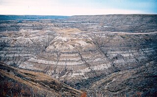
The Muskiki Formation is a stratigraphical unit of Late Cretaceous age in the Western Canadian Sedimentary Basin.
Within the earth science of geology, the Edmonton Group is a Late Cretaceous to early Paleocene stratigraphic unit of the Western Canada Sedimentary Basin in the central Alberta plains. It was first described as the Edmonton Formation by Joseph Burr Tyrrell in 1887 based on outcrops along the North Saskatchewan River in and near the city of Edmonton. E.J.W. Irish later elevated the formation to group status and it was subdivided into four separate formations. In ascending order, they are the Horseshoe Canyon, Whitemud, Battle and Scollard Formations. The Cretaceous-Paleogene boundary occurs within the Scollard Formation, based on dinosaurian and microfloral evidence, as well as the presence of the terminal Cretaceous iridium anomaly.
The Minnes Group, originally named the Minnes Formation, is a geologic unit of latest Jurassic to earliest Cretaceous age in the Western Canada Sedimentary Basin. It is present in the northern foothills of the Canadian Rockies and the adjacent plains in northeastern British Columbia and west-central Alberta. Its strata include natural gas reservoirs and minor coal deposits. Fossil dinosaur tracks have been described from one of its formations.
The Blairmore Group, originally named the Blairmore Formation, is a geologic unit of Early Cretaceous age in the Western Canada Sedimentary Basin that is present in southwestern Alberta and southeastern British Columbia. It is subdivided into four formations: Cadomin Formation, Gladstone, Beaver Mines and Ma Butte, all of which are defined by type sections, most of which contain plant fossils. In some areas the Blairmore contains significant reservoirs of natural gas.
The Mount Whyte Formation is a stratigraphic unit that is present on the western edge of the Western Canada Sedimentary Basin in the southern Canadian Rockies and the adjacent southwestern Alberta plains. It was deposited during Middle Cambrian time and consists of shale interbedded with other siliciclastic rock types and limestones. It was named for Mount Whyte in Banff National Park by Charles Doolittle Walcott, the discoverer of the Burgess shale fossils, and it includes several genera of fossil trilobites.
The Beattie Peaks Formation is a geologic formation of Early Cretaceous (Valanginian) age in the Western Canada Sedimentary Basin that consists primarily of marine mudstone. It is present in the northern foothills of the Canadian Rockies and the adjacent plains in northeastern British Columbia.
The Monach Formation is a geologic formation of Early Cretaceous (Valanginian) age in the Western Canada Sedimentary Basin that consists primarily of sandstone. It is present in the northern foothills of the Canadian Rockies and the adjacent plains in northeastern British Columbia.
The Monteith Formation is a geologic formation of Early Cretaceous (Valanginian) age in the Western Canada Sedimentary Basin that consists primarily of sandstone. It is present in the northern foothills of the Canadian Rockies and the adjacent plains in northeastern British Columbia and west-central Alberta.
The Beaver Mines Formation is a stratigraphic unit of Early Cretaceous (Albian) age in the Western Canada Sedimentary Basin that is present in southwestern Alberta and southeastern British Columbia, Canada. It was established by G.B. Mellon in 1967 who named it for the hamlet of Beaver Mines, Alberta. It contains a variety of plant fossils.
The Boulder Creek Formation is a geologic formation in northeastern British Columbia. It was named for a tributary to Commotion Creek in the Pine Pass area by E.M. Spieker in 1921. At one time considered to be a member of the Commotion Formation, it was elevated to formation status by D.F. Stott in 1982.
The Kootenay Group, originally called the Kootenay Formation, is a geologic unit of latest Jurassic to earliest Cretaceous age in the Western Canada Sedimentary Basin that is present in the southern and central Canadian Rockies and foothills. It includes economically important deposits of high-rank bituminous and semi-anthracite coal, as well as plant fossils and dinosaur trackways.
The Gorman Creek Formation is a geologic formation of Early Cretaceous (Valanginian) age in the Western Canada Sedimentary Basin that consists primarily of nonmarine sediments. It is present in the northern foothills of the Canadian Rockies and the adjacent plains in northeastern British Columbia. Plant fossils and dinosaur tracks have been described from its strata.
The Bickford Formation is a geologic formation of Early Cretaceous (Valanginian) age in the Western Canada Sedimentary Basin that consists primarily of nonmarine sediments. It is present in the northern foothills of the Canadian Rockies in northeastern British Columbia.
The Luscar Group is a geologic unit of Early Cretaceous age in the Western Canada Sedimentary Basin that is present in the foothills of southwestern Alberta. It is subdivided into a series of formations, some of which contain economically significant coal deposits that have been mined near Cadomin and Luscar. Coal mining in those areas began in the early 1900s and continues near Luscar as of 2016.
Toad Formation, Grayling Formation, and Toad-Grayling Formation are obsolete names for the strata of the Early to Middle Triassic Doig and Montney Formations. They were applied in the foothills and Rocky Mountains of northeastern British Columbia, on the western edge of the Western Canada Sedimentary Basin. Although the names are considered obsolete, their usage persists.