Related Research Articles

Alberta is a Canadian province. Located in Western Canada, the province has an area of 661,190 square kilometres (255,290 sq mi) and is bounded to the south by the U.S. state of Montana along 49° north for 298 kilometres (185 mi); to the east at 110° west by the province of Saskatchewan for 1,223 kilometres (760 mi); and at 60° north the Northwest Territories for 644 kilometres (400 mi). The southern half of the province borders British Columbia along the Continental Divide of the Americas on the peaks of the Rocky Mountains, while the northern half borders British Columbia along the 120th meridian west. It is one of only two landlocked provinces.

The Peace River is a 1,923-kilometre-long (1,195 mi) river in Canada that originates in the Rocky Mountains of northern British Columbia and flows to the northeast through northern Alberta. The Peace River joins the Athabasca River in the Peace-Athabasca Delta to form the Slave River, a tributary of the Mackenzie River. The Finlay River, the main headwater of the Peace River, is regarded as the ultimate source of the Mackenzie River. The combined Finlay–Peace–Slave–Mackenzie river system is the 13th longest river system in the world.

The Liard River of the North American boreal forest flows through Yukon, British Columbia and the Northwest Territories, Canada. Rising in the Saint Cyr Range of the Pelly Mountains in southeastern Yukon, it flows 1,115 kilometres (693 mi) southeast through British Columbia, marking the northern end of the Rocky Mountains and then curving northeast back into Yukon and Northwest Territories, draining into the Mackenzie River at Fort Simpson, Northwest Territories. The river drains approximately 277,100 square kilometres (107,000 sq mi) of boreal forest and muskeg.

The Squamish River is a short but very large river in the Canadian province of British Columbia. Its drainage basin is 3,328 square kilometres (1,285 sq mi) in size. The total length of the Squamish River is approximately 80 kilometres (50 mi).

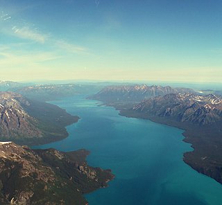
Tŝilhqox Biny, known as Chilko Lake, is a 180 km2 lake in west-central British Columbia, at the head of the Chilko River on the Chilcotin Plateau. The lake is about 65 km long, with a southwest arm 10 km long. It is one of the largest lakes by volume in the province because of its great depth, and the largest above 1,000 m in elevation. It and Harrison Lake are the largest lakes in the southern Coast Mountains.

Mount Tatlow is one of the principal summits of the Chilcotin Ranges subdivision of the Pacific Ranges of the Coast Mountains of southern British Columbia. Standing on an isolated ridge between the lower end of Chilko Lake and the Taseko Lakes, it is 3,063 m (10,049 ft) in elevation.

Kiskatinaw is a tributary of the Peace River in northeastern British Columbia, Canada.

The Pouce Coupe River is a major tributary of the Peace River in Alberta and British Columbia, Canada. Its name is officially spelled Pouce Coupé River, but it is commonly written without the acute accent.

The Dartmouth Range is a mountain range in the White Mountains of New Hampshire in the United States. The range lies in the township of Low and Burbank's Grant and the town of Carroll in Coos County.
The Doig River is a river in Alberta and northern British Columbia, Canada.

The Robson River is a short but swift, rapid and waterfall-infested river in Mount Robson Provincial Park of British Columbia. It is a tributary of the Upper Fraser River and it originates near Robson Pass, which divides the Robson River and the headwaters of the Smoky River drainage. There are three lakes along the river’s course as well as four waterfalls.
The Spirit River is a river in northern Alberta, Canada. The name is a translation of the Cree words Chepe Sepi, meaning ghost or spirit.
The Prophet River is a river in northern British Columbia, Canada. It is a tributary of the Muskwa River.
Besa River is a river in northern British Columbia, Canada. It is a tributary of the Prophet River.

The Redwillow River is a tributary of the Wapiti River in northern Alberta and north-eastern British Columbia, Canada. It flows through the Pouce Coupe Prairie, in the south of Peace River Country.
The Puskwaskau River is a short river in Northern Alberta, Canada. It is a tributary of the Smoky River flowing westwards in the Peace River Country. Its waters flow through the Smoky River, Peace River, Slave River, Great Slave Lake and Mackenzie River into the Arctic Ocean.

The Barkly River, a perennial river of the West Gippsland catchment, is located in the Alpine region of the Australian state of Victoria.

The Mount Cayley massif is a group of mountains in the Pacific Ranges of southwestern British Columbia, Canada. Located 45 km (28 mi) north of Squamish and 24 km (15 mi) west of Whistler, the massif resides on the edge of the Powder Mountain Icefield. It consists of an eroded but potentially active stratovolcano that towers over the Cheakamus and Squamish river valleys. All major summits have elevations greater than 2,000 m (6,600 ft), Mount Cayley being the highest at 2,385 m (7,825 ft). The surrounding area has been inhabited by indigenous peoples for more than 7,000 years while geothermal exploration has taken place there for the last four decades.

The Zymagotitz River is a tributary of the Skeena River located in the North Coast Regional District of the province of British Columbia, Canada. It originates in the Kitimat Ranges of the Coast Mountains, and flows south and west about 45 km (28 mi) to the Skeena River, about 10 km (6.2 mi) downriver from Terrace and about 100 km (62 mi) east of Prince Rupert.
References
- ↑ "Halfway River First Nation". Archived from the original on 2011-07-06. Retrieved 2009-02-14.